
Image: Upper end of Cow Island, in the Missouri, below the mouth of Cow Creek, Missouri Breaks, Motnana

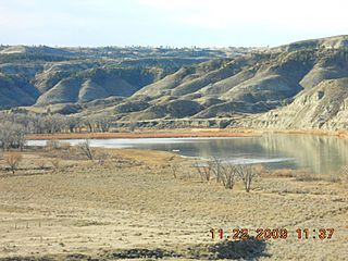
Description: This is a view of the upper end of Cow Island, in the Missouri. It lies just below the mouth of Cow Creek. The island is created from sediments washing out from Cow Creek in flood season. This is one of the larger islands in the Missouri. It forms a natural crossing point on the Missouri. During the steamboat era (1860 to the mid 1880's) the Missouri was the path way to the mines in western Montana. Above this point the Missouri had many rapids. In the summer and fall, the river levels dropped, and steamboats could not get up to Ft. Benton, the up river terminus. They had to drop their cargos here. This area became known as Cow Island Landing. The freight was then north and west hauled up Cow Creek, through the Missouri Breaks and out onto the northern Montana plains and on to Ft. Benton. In ancient times Cow Island was a Missouri River crossing point for bison and nomadic Indians. Now the bison and Indians are gone, as are the steamboats. Cow Island lies in a remote and isolated area of the Missouri Breaks in Montana.
Title: Upper end of Cow Island, in the Missouri, below the mouth of Cow Creek, Missouri Breaks, Motnana
Credit: Own work
Author: Montana Geographic Society
Usage Terms: Creative Commons Attribution-Share Alike 3.0
License: CC BY-SA 3.0
License Link: http://creativecommons.org/licenses/by-sa/3.0
Attribution Required?: Yes
Image usage
The following 2 pages link to this image:
