
Image: Usgs map azimuthal equidistant
No higher resolution available.
Usgs_map_azimuthal_equidistant.PNG (487 × 162 pixels, file size: 46 KB, MIME type: image/png)
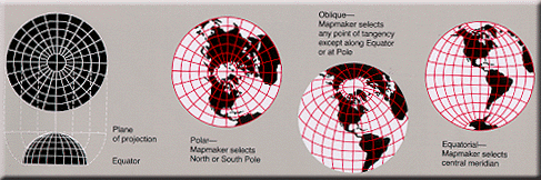
Description: Condensed explanation of azimuthal-equidistant projection maps, colored as smaller PNG image, from larger, wider USGS file of GIF format. See enlarged view below, using a wikitable to expand beyond original size.
Title: Usgs map azimuthal equidistant
Credit: derivative from USGS image file (with map sections colored red/white), URL: http://erg.usgs.gov/isb/pubs/MapProjections/graphics/azimuthal.gif
Author: User:Quadell, re-coloring US Government USGS image.
Usage Terms: Public domain
License: Public domain
Attribution Required?: No
Image usage
The following page links to this image:

All content from Kiddle encyclopedia articles (including the article images and facts) can be freely used under Attribution-ShareAlike license, unless stated otherwise.