
Image: Utah Territory evolution animation - August 2011

Size of this preview: 763 × 600 pixels. Other resolutions: 305 × 240 pixels | 1,000 × 786 pixels.
Original image (1,000 × 786 pixels, file size: 158 KB, MIME type: image/gif, looped, 6 frames, 15 s)
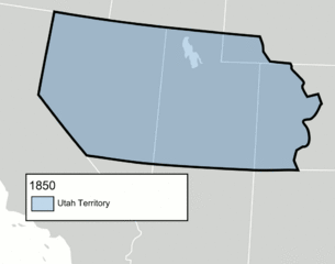
Description: An animated GIF of the Utah Territory as it evolved from 1850 to 1896, when statehood was granted. The territory's boundaries may not be exact.
Title: Utah Territory evolution animation - August 2011
Credit: Blank_US_Map.svg Wpdms utah territory 1851 idx.png File:1855 Colton Map of Utah and New Mexico (first edition, first state) - Geographicus - UtahNewMexico-colton-1855.jpg
Author: derivative work: Mangoman88 (talk) Blank_US_Map.svg: User:Theshibboleth Wpdms utah territory 1851 idx.png: User:Tsujigiri
Usage Terms: Creative Commons Attribution-Share Alike 3.0
License: CC-BY-SA-3.0
License Link: http://creativecommons.org/licenses/by-sa/3.0/
Attribution Required?: Yes
Image usage
The following 2 pages link to this image:

All content from Kiddle encyclopedia articles (including the article images and facts) can be freely used under Attribution-ShareAlike license, unless stated otherwise.