
Image: Utah Territory with Deseret Border, vector image - 2011

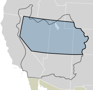
Description: The Utah Territory shown with the proposed State of Deseret, underlaid with a modern map of the United States. The proposed boundary of Deseret is the dotted line, while the Utah Territory is blue, and outlined in black; boundaries are not exact.
Title: Utah Territory with Deseret Border, vector image - 2011
Credit: Blank_US_Map.svg Wpdms deseret utah territory legend.png File:1855 Colton Map of Utah and New Mexico (first edition, first state) - Geographicus - UtahNewMexico-colton-1855.jpg
Author: derivative work: Mangoman88 (talk) Blank_US_Map.svg: User:Theshibboleth Wpdms deseret utah territory legend.png: User:Tsujigiri
Usage Terms: Creative Commons Attribution-Share Alike 3.0
License: CC-BY-SA-3.0
License Link: http://creativecommons.org/licenses/by-sa/3.0/
Attribution Required?: Yes
Image usage
The following 3 pages link to this image:
