
Image: Vanatinai, Louisiade Archipelago

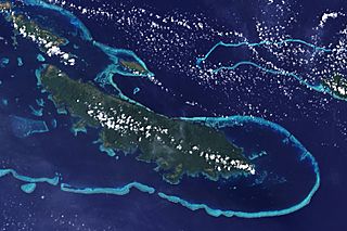
Description: The lower corner of the scene shows part of the northwestern coast of the largest island in the archipelago, Vanatinai. Most of the island is densely covered in lowland rainforest, but clearing for agricultural land is widespread around the perimeter, especially in the northwest. The shallow waters covering an extensive network of reefs are electric blue. A sinuous channel of deep, clear water (image center) connects a partially enclosed lagoon north of Vanatinai with the bay south of Yeina Island.
Title: Vanatinai, Louisiade Archipelago
Credit: NASA Earth Observatory
Author: NASA image by Jesse Allen and Rob Simmon, using data provided by the United States Geological Survey.
Usage Terms: Public domain
License: Public domain
Attribution Required?: No
Image usage
The following 2 pages link to this image:
