
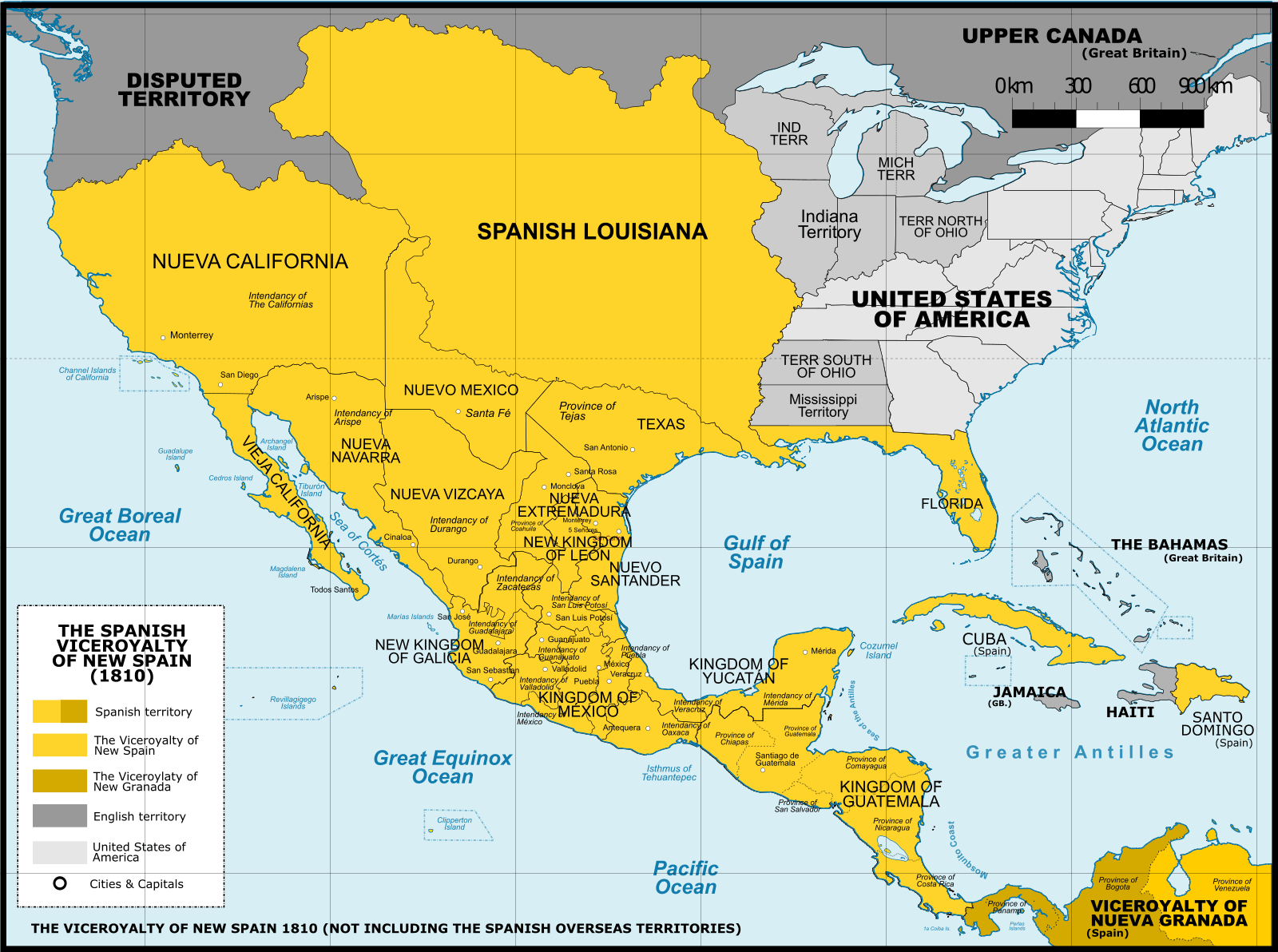
Image: Viceroyalty of the New Spain 1800 (without Philippines)
Description: Map of the Viceroyalty of New Spain in 1800. Not including the viceroyalty's overseas territories in the Pacific Ocean. Territorial organization of the Viceroyalty of New Spain (1535-1786) New Kingdom of León: Nuevo León and Tamaulipas. Kingdom of Mexico: Mexico City, Puebla, Michoacán, Mexico, Hidalgo, Tlaxcala, Querétaro, and parts of Guerrero, Michoacán and Oaxaca. Kingdom of New Galicia: Jalisco, Nayarit, Aguascalientes, Zacatecas and Colima. Kingdom of New Vizcaya: Durango, Coahuila and Sinaloa. Kingdom of Guatemala: Guatemala, Belize, El Salvador, Honduras, Nicaragua, Costa Rica and Chiapas. Capitanía General de Yucatán: Yucatán, Campeche, Quintana Roo and parts de Tabasco, Peten and Belzie. Territorial organization of the Viceroyalty of New Spain (1786-1821) Royal Audiencia of Mexico Intendency of Mexico Intendency of Antequera Province of Oaxaca Intendency of Veracruz Intendency of Valladolid Intendency of New Vizcaya Province of Durango Intendency of New Extremadura Province of Sonora / Arizpe Province of Sinaloa Intendency of Mérida Intendency of Puebla de los Ángeles Province of Tlaxcala (1793-1981) Royal Audiencia of Guadalajara Intendency of Guadalajara Intendency of San Luis Potosí Province of Texas Province of Coahuila Province of New Reino de León Province of New Santander Intendency of Zacatecas Government of New Mexico Government of the Californias Government of Upper California (1804-1821) Government of Lower California (1804-1821) Captaincy General of Philippines (1565-1898) : Palaos, Guam, the Marianas, Caroline Islands, Saba and Maluku Islands. Captaincy General of Guatemala (1540-1821): Guatemala, Belice, El Salvador, Honduras, Nicaragua, Costa Rica and Chiapas. Captaincy General of Puerto Rico (1582-1898): Puerto Rico (US). Captaincy General of Cuba (1821-1898): Cuba, Florida (US), Nebraska (US), Kansas (US), and parts of Montana (US), Wyoming (US), Iowa (US), Missouri (US), Arkansas (US), North Dakota (US), South Dakota (US), Louisiana (US), Oklahoma (US), Colorado (US) and Minnesota (US). Spanish Louisiana (1764-1803) La Florida (1513-1821) Captaincy General of Saint Domingo (1493-1821): Haiti, Dominican Republic.
Title: Viceroyalty of the New Spain 1800 (without Philippines)
Credit: A map created using information from the United States Geological Survey, an agency of the United States Department of Interior 1800, 1810, 1820 and from the Secretary of the Public Education of Mexico (Secretaría de Educación Pública de México) with 500 años de documentos COMMENT on 1 April 2015: The map above is still captioned "1810," instead of 1800. This is unfortunate and confusing, because in 1803 Spanish Louisiana was tranferred (to France and then) to the United States, so it makes the map appear to contain a serious error.
Author: Giggette
Usage Terms: Creative Commons Attribution-Share Alike 3.0
License: CC BY-SA 3.0
License Link: http://creativecommons.org/licenses/by-sa/3.0
Attribution Required?: Yes
Image usage
The following 2 pages link to this image:

.png)