
Image: Vichy france map

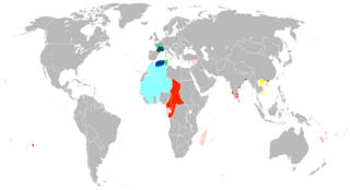
Description: Map of Vichy France and the loss of its territory to Free France and the Axis powers. Legend: Colonies under the control of Free France by September 1940 Colonies under the control of Free France by November 1942 Colonies under the control of Free France in November 1942 after operation Torch Metropolitan France (French Algeria) under the control of Free France in November 1942 after operation Torch Metropolitan france (zone libre) under Vichy control until occupied by the Axis in November 1942 after operation Torch (with Corsica under the control of Free France in September 1943). Colony occupied by the Axis (French Tunisia) in November 1942 after operation Torch, under the control of Free France by May 1943 Colonies under the control of Free France by July 1943 (French Somaliland and French West Indies) French Indochina colony (Tonkin) under Japanese occupation by September 1940. Rest of French Indochina under Japanese and Thai occupation by July 1941. Occupied metropolitan France under Axis control (German zones and Italian zones) after the fall of the Third Republic in June 1940, under Free French control by August 1944.
Title: Vichy france map
Credit: Transferred from en.wikipedia to Commons by Innotata using CommonsHelper.
Author: VoodooIsland at English Wikipedia. A modificatio was made by Morgan Hauser at en.wikipedia.
Usage Terms: Public domain
License: Public domain
Attribution Required?: No
Image usage
The following page links to this image:
