
Image: Warwickshire UK location map

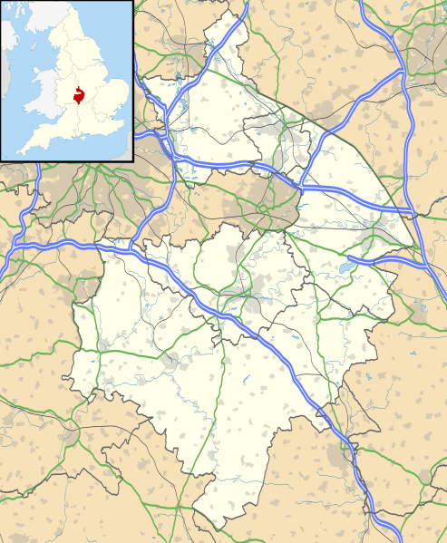
Description: Map of Warwickshire, UK with the following information shown: Administrative borders Coastline, lakes and rivers Roads and railways Urban areas Equirectangular map projection on WGS 84 datum, with N/S stretched 160% Geographic limits: West: 2.10W East: 1.10W North: 52.70N South: 51.94N
Title: Warwickshire UK location map
Credit: Ordnance Survey OpenData. Administrative borders and coastline data from Boundary-Line product. All other geographic data from Meridian 2 product. Inset derived from England location map.svg by Spischot.
Author: Nilfanion, created using Ordnance Survey data
Permission: This file is licensed under the Creative Commons Attribution-Share Alike 3.0 Unported license. Attribution: Contains Ordnance Survey data © Crown copyright and database right You are free: to share – to copy, distribute and transmit the work to remix – to adapt the work Under the following conditions: attribution – You must attribute the work in the manner specified by the author or licensor (but not in any way that suggests that they endorse you or your use of the work). share alike – If you alter, transform, or build upon this work, you may distribute the resulting work only under the same or similar license to this one. http://creativecommons.org/licenses/by-sa/3.0 CC BY-SA 3.0 Creative Commons Attribution-Share Alike 3.0 truetrue
Usage Terms: Creative Commons Attribution-Share Alike 3.0
License: CC BY-SA 3.0
License Link: http://creativecommons.org/licenses/by-sa/3.0
Attribution Required?: Yes
Image usage
The following 35 pages link to this image:
- Alcester
- Atherstone
- Baginton
- Bedworth
- Brinklow Castle
- Cestersover
- Church of St Nicholas and St Peter ad Vincula, Curdworth
- Coleshill, Warwickshire
- Collegiate Church of St Mary, Warwick
- Curdworth
- Edge Hill, Warwickshire
- Flowers Wood
- Grafton Preceptory
- Henley-in-Arden
- Kenilworth
- Kenilworth Castle
- Leamington Spa
- Mancetter
- Northgate Street drill hall, Warwick
- Nuneaton
- RAF Lilbourne
- Radway
- Rugby, Warwickshire
- Seckington
- Shipston-on-Stour
- Southam
- St Andrew's Church, Rugby
- St Mary Immaculate Roman Catholic Church, Warwick
- Stratford-upon-Avon
- The Old Barracks, Warwick
- Warwick
- Water Orton
- Whitnash
- Wolfhampcote
- Template:Location map United Kingdom Warwickshire
