
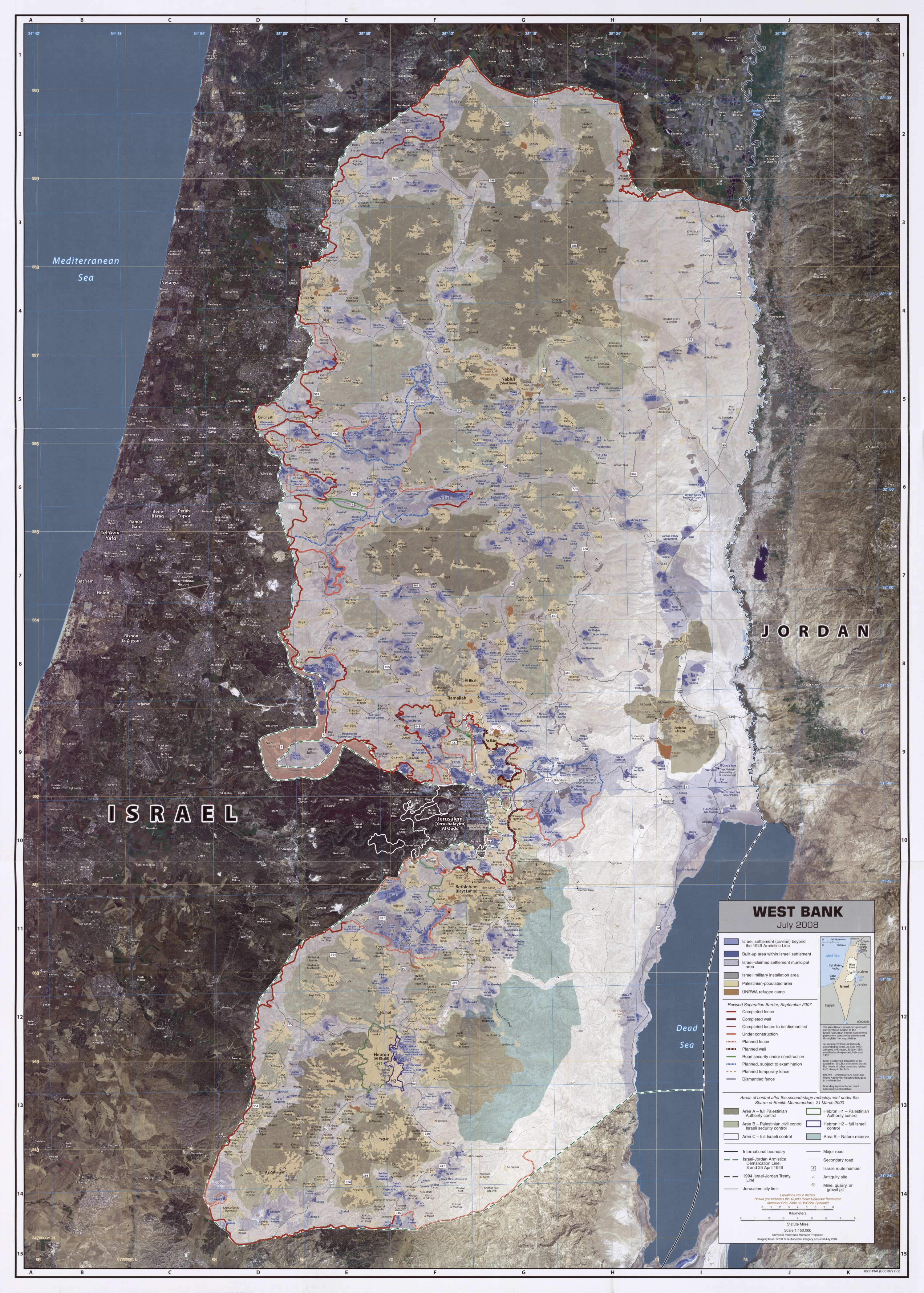
Image: West Bank July 2008 CIA remote-sensing map 3000px
Description: West Bank. United States. Central Intelligence Agency. CREATED/PUBLISHED [Washington, D.C. : Central Intelligence Agency, 2008] NOTES "July 2008." Relief shown by spot heights. "Boundary representation is not necessarily authoritative." Universal transverse Mercator grid, zone 36. Includes location map. Indexes of Israeli settlement areas and Palestinian-populated areas on verso. "803313AI (G00197) 7-08." Scale 1:150,000 ; universal transverse Mercator proj. (E 34042'--E 35042'/N 32030'--N 31024'). MEDIUM 1 map : col. ; 94 x 67 cm. CALL NUMBER G7512.W4 2008 .U5 REPOSITORY Library of Congress Geography and Map Division Washington, D.C. 20540-4650 USA DIGITAL ID g7512w ct002357 http://hdl.loc.gov/loc.gmd/g7512w.ct002357 This is a smaller 3000-pixel-wide version of the original map. The original map on the Commons is 10,984 × 15,369 pixels, file size: 45.83 MB. This 3000-pixel-wide version of the map is 10.3 MB. Map shows areas interpreted by the CIA as Israeli settlements, Israeli claimed settlement municipal areas, Israeli-military installation areas, Palestinian-populated areas and UNRWA refugee camps together with the West Bank barrier and the various 'Areas of control'
Title: West Bank July 2008 CIA remote-sensing map 3000px
Credit: West Bank July 2008 CIA remote-sensing map.jpg
Author: West Bank July 2008 CIA remote-sensing map.jpg:CIA derivative work: Sean.hoyland (talk) 10:15, 3 October 2011 (UTC)
Usage Terms: Public domain
License: Public domain
Attribution Required?: No
Image usage
The following page links to this image:
