
Image: Western Capercaillie Tetrao urogallus distribution map
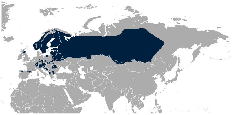
Description: Geographical distribution of the Western Capercaillie Tetrao urogallus. The map was created using the Generic Mapping Tools, GMT, version 5.1.2.
Title: Western Capercaillie Tetrao urogallus distribution map
Credit: Own work using: the IUCN Red List spatial data to draw the borders of the Tetrao urogallus range: http://maps.iucnredlist.org/map.html?id=22679487 Credit for the spatial data: BirdLife International and NatureServe (2014) Bird Species Distribution Maps of the World. 2012. Tetrao urogallus. In: IUCN 2014. The IUCN Red List of Threatened Species. Version 2014.3. http://www.iucnredlist.org. Downloaded on 02 June 2015. Species account: http://www.iucnredlist.org/details/22679487/0 BirdLife International 2012. Tetrao urogallus. The IUCN Red List of Threatened Species. Version 2015.1. <www.iucnredlist.org>. Downloaded on 02 June 2015. [[File:|32x20px]] This map was created with GMT.
Author: Darekk2 using the IUCN Red List spatial data
Usage Terms: Creative Commons Attribution-Share Alike 4.0
License: CC BY-SA 4.0
License Link: https://creativecommons.org/licenses/by-sa/4.0
Attribution Required?: Yes
Image usage
The following page links to this image:
