
Image: Wisconsin geographic provinces

Size of this PNG preview of this SVG file: 585 × 600 pixels. Other resolution: 234 × 240 pixels.
Original image (SVG file, nominally 1,015 × 1,041 pixels, file size: 213 KB)
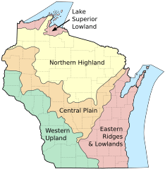
Description: Map of the geographic regions of Wisconsin.
Title: Wisconsin geographic provinces
Credit: Own work based on the following sources: Base map for state and county boundaries: File:Map of Wisconsin highlighting Adams County.svg by David Benbennick (public domain). Geographic regions based on: File:The-five-geographical-provinces-of-Wisconsin.gif by Lawrence Martin, published 1916 (public domain).
Author: User:Jua Cha
Usage Terms: Public domain
License: Public domain
Attribution Required?: No
Image usage
The following 3 pages link to this image:

All content from Kiddle encyclopedia articles (including the article images and facts) can be freely used under Attribution-ShareAlike license, unless stated otherwise.