
Image: Wpdms terra buttermilk channel
No higher resolution available.
Wpdms_terra_buttermilk_channel.jpg (300 × 266 pixels, file size: 24 KB, MIME type: image/jpeg)
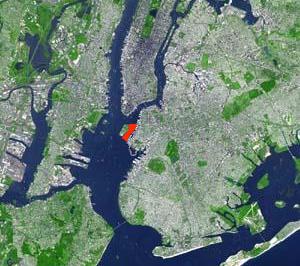
Description: The Buttermilk Channel (shown in red) in Upper New York Bay separating Governors Island and Brooklyn. Originally satellite photo by NOAA © 2004 Matthew Trump.
Title: Wpdms terra buttermilk channel
Credit: Transferred from en.wikipedia to Commons.
Author: Decumanus at English Wikipedia
Usage Terms: Creative Commons Attribution-Share Alike 3.0
License: CC-BY-SA-3.0
License Link: http://creativecommons.org/licenses/by-sa/3.0/
Attribution Required?: Yes
Image usage
The following page links to this image:

All content from Kiddle encyclopedia articles (including the article images and facts) can be freely used under Attribution-ShareAlike license, unless stated otherwise.