
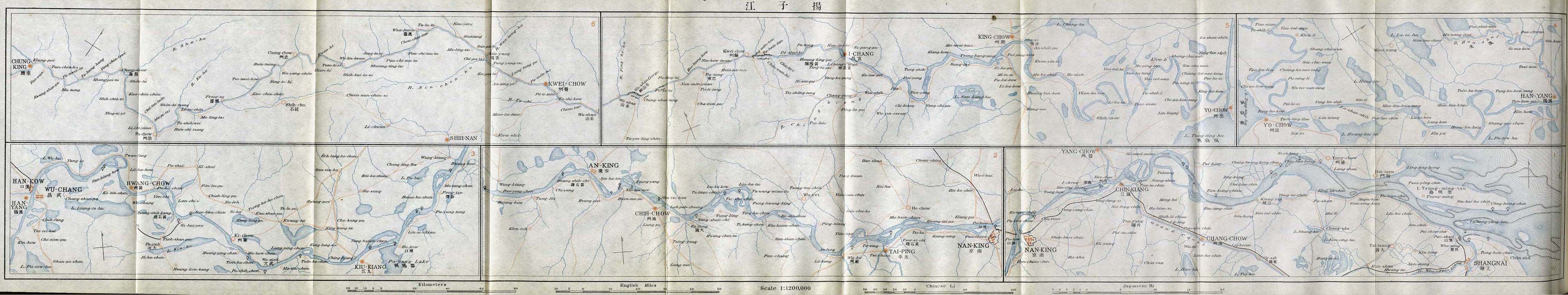
Image: Yangtze kiang 1915
Size of this preview: 800 × 151 pixels. Other resolutions: 320 × 60 pixels | 4,534 × 854 pixels.
Original image (4,534 × 854 pixels, file size: 560 KB, MIME type: image/jpeg)
Description: The map of the Yangtze Valey, scale 1;1,200,000. From An Official Guide to Eastern Asia, Volume IV: China. Published by The Imperial Japanese Government Railways. Tokyo, 1915.
Title: Yangtze kiang 1915
Credit: http://www.lib.utexas.edu/maps/historical/yangtze_kiang_1915.jpg in Perry-Castañeda Library Map Collection (http://www.lib.utexas.edu/maps/historical/history_china.html )
Author: Compilers of " An Official Guide to Eastern Asia, Volume IV: China. Published by The Imperial Japanese Government Railways. Tokyo, 1915. "
Usage Terms: Public domain
License: Public domain
Attribution Required?: No
Image usage
There are no pages that link to this image.

All content from Kiddle encyclopedia articles (including the article images and facts) can be freely used under Attribution-ShareAlike license, unless stated otherwise.