
Image: Zion-Mount Carmel Highway, Zion National Park, Utah (1025814726)

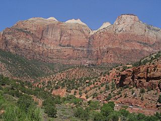
Description: Zion National Park is located in the Southwestern United States, near Springdale, Utah. A prominent feature of the 229-square-mile (590 km2) park is Zion Canyon, which is 15 miles (24 km) long and up to half a mile (800 m) deep, cut through the reddish and tan-colored Navajo Sandstone by the North Fork of the Virgin River. The lowest elevation is 3,666 ft (1,117 m) at Coalpits Wash and the highest elevation is 8,726 ft (2,660 m) at Horse Ranch Mountain. Located at the junction of the Colorado Plateau, Great Basin, and Mojave Desert regions, the park's unique geography and variety of life zones allow for unusual plant and animal diversity. Numerous plant species as well as 289 species of birds, 75 mammals (including 19 species of bat), and 32 reptiles inhabit the park's four life zones: desert, riparian, woodland, and coniferous forest. Zion National Park includes mountains, canyons, buttes, mesas, monoliths, rivers, slot canyons, and natural arches. The geology of the Zion and Kolob canyons area includes 9 formations that together represent 150 million years of mostly Mesozoic-aged sedimentation. At various periods in that time warm, shallow seas, streams, ponds and lakes, vast deserts, and dry near-shore environments covered the area. Uplift associated with the creation of the Colorado Plateaus lifted the region 10,000 feet (3,000 m) starting 13 million years ago. The park is located in southwestern Utah in Washington, Iron and Kane counties. Geomorphically, it is located on the Markagunt and Kolob plateaus, at the intersection of three North American geographic provinces: the Colorado Plateaus, the Great Basin, and the Mojave Desert. The northern part of the park is known as the Kolob Canyons section and is accessible from Interstate 15, exit 40. The east side of the park is served by Zion–Mount Carmel Highway, which passes through the Zion–Mount Carmel Tunnel and ends at Mount Carmel Junction, Utah. On the east side of the park, notable park features include Checkerboard Mesa (photo) and the East Temple. en.wikipedia.org/wiki/Zion_National_Park en.wikipedia.org/wiki/Wikipedia:Text_of_Creative_Commons_...
Title: Zion-Mount Carmel Highway, Zion National Park, Utah (1025814726)
Credit: Zion-Mount Carmel Highway, Zion National Park, Utah
Author: Ken Lund from Reno, Nevada, USA
Usage Terms: Creative Commons Attribution-Share Alike 2.0
License: CC BY-SA 2.0
License Link: https://creativecommons.org/licenses/by-sa/2.0
Attribution Required?: Yes
Image usage
The following page links to this image:

.jpg)