
Lake Malawi facts for kids
Quick facts for kids Lake Malawi |
|
|---|---|

View from orbit
|
|
| Coordinates | 12°11′S 34°22′E / 12.183°S 34.367°E |
| Type | Rift lake |
| Primary inflows | Ruhuhu River |
| Primary outflows | Shire River |
| Basin countries | Malawi, Mozambique, Tanzania |
| Max. width | 75 km |
| Surface area | 29,600 km2 (11,400 sq mi) |
| Average depth | 292 m |
| Max. depth | 706 m |
| Water volume | 8,400 km³ |
| Surface elevation | 500 meters above sea level |
| Islands | Likoma and Chizumulu islets |
Lake Malawi (or Lake Nyasa, Lake Niassa) is a lake in Africa. It is the southernmost lake in the East African Rift system. It is shared between Malawi, Mozambique and Tanzania. Before Malawi became independent in 1964, the territory was called Nyasaland. For this reason, Mozambique and Tanzania call the lake Lake Nyasa.
Lake Malawi is the third largest and second deepest lake in Africa. It is the ninth largest lake in the world.
Images for kids
-
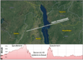
Topographic profile of Lake Malawi's rift shoulder
-
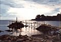
A jetty juts into the lake at Nkhata Bay
-
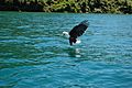
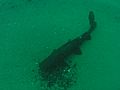
An African fish eagle catching a fish in Lake Malawi
-
Lake Malawi sardines (Engraulicypris sardella) spread out to dry on the shore of the lake
-
The kampango (Bagrus meridionalis), one of the largest catfish, reaching up to 1.5 m (4.9 ft) in length
-
Huge swarms of lake flies (Chaoborus edulis), resembling distant plumes of smoke over the water
-
Lake Malawi (1967)
-
Mwaya Beach
-
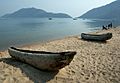
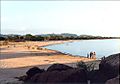
Beach at Cape Maclear near Monkey Bay


.jpg)


See also
 In Spanish: Lago Malaui para niños
