Danbury Township, Ottawa County, Ohio facts for kids
Quick facts for kids
Danbury Township, Ottawa County, Ohio
|
|
|---|---|

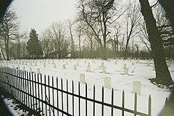
Cemetery on Johnson's Island
|
|

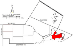
Location of Danbury Township in Ottawa County.
|
|
| Country | United States |
| State | Ohio |
| County | Ottawa |
| Area | |
| • Total | 56.5 sq mi (146.4 km2) |
| • Land | 18.2 sq mi (47.2 km2) |
| • Water | 38.3 sq mi (99.2 km2) |
| Elevation | 640 ft (195 m) |
| Population
(2000)
|
|
| • Total | 4,631 |
| • Density | 254.4/sq mi (98.2/km2) |
| Time zone | UTC-5 (Eastern (EST)) |
| • Summer (DST) | UTC-4 (EDT) |
| FIPS code | 39-20058 |
| GNIS feature ID | 1086760 |
| Website | Danbury Township |
Danbury Township is one of the twelve townships of Ottawa County, Ohio, United States. The 2000 census found 4,631 people in the township, 3,869 of whom lived in the unincorporated portions of the township.
Communities
- Danbury is an Unincorporated community located within the southwest portion of the Township on the southwest portion of the Marblehead Peninsula along the shore of the Sandusky Bay.
- Lakeside is an Unincorporated community an Census designated plate located at 41°32′36″N 82°45′5″W / 41.54333°N 82.75139°W along the shore of Lake Erie in the Northeast portion of the Township on the Northeast portion of the Marblehead Peninsula.The entire community is listed on the National Register of Historic Places as the Lakeside Historic District.
- Lakeside Marblehead is an Unincorporated community located in the Northeast portion of the Township on the Northeast portion of the Marblehead Peninsula along the shores of Lake Erie. Lakeside Marblehead borders Lakeside and Marblehead.
- Marblehead is a Village located at 41°32′5″N 82°43′45″W / 41.53472°N 82.72917°W in the Eastern portion of the Township and the Eastern portion of the Marblehead Peninsula along the shores of Lake Erie.
Name and history
It is the only Danbury Township statewide. This township is included in the region known as the Firelands and was originally a part of Huron County. It was named for Danbury, Connecticut, the native home of a large share of the first settlers.
Huron County was established by the Ohio General Assembly on February 7, 1809 and, at the time, comprised present-day Erie County (except for a small piece in the west); Huron County, Ruggles Township in Ashland County, Danbury Township, and part of Catawba Island Township.
Johnson's Island, the location of a significant Prisoner-of-war camp during the Civil War, is located in Sandusky Bay just south of the Marblehead Peninsula. It is now a part of the village of Marblehead.
Geography
Located at the eastern point of the county at the end of the Marblehead Peninsula, it borders the following townships:
- Kelleys Island - northeast, across Lake Erie
- Sandusky - southeast, across Sandusky Bay
- Margaretta Township, Erie County - south, across Sandusky Bay
- Portage Township - west
- Catawba Island Township - northwest
Demographics
The median age of males is 48.0 years of age. The median age of females is 48.6 years of age.
The median income for a household in the township was $55,578 in 2008. In 1999, the median income for a household in the township was $47,434.
Notable residents
- Louis C. Shepard, Medal of Honor recipient during the Civil War.
See also
 In Spanish: Municipio de Danbury (Ohio) para niños

