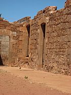
List of State Register of Heritage Places in the Shire of Ashburton facts for kids
This is a list of State Register of Heritage Places in the Shire of Ashburton, Western Australia. The State Register of Heritage Places is maintained by the Heritage Council of Western Australia.
As of 2020, 84 places are heritage-listed in the Shire of Ashburton,
List
The Western Australian State Register of Heritage Places, as of 2020, lists the following six state registered places within the Shire of Ashburton:
| Place name | Place # | Location | Suburb or town | Co-ordinates | Built | State registered |
Notes | Photo |
|---|---|---|---|---|---|---|---|---|
| Nanutarra Station Complex | 1743 | Lot 4 North West Coastal Highway | Nanutarra | 22°32′20″S 115°29′53″E / 22.53889°S 115.49806°E | 1878 | 4 November 2005 |
|
 |
| Old Onslow Townsite | 3444 | Reserve 35118 | Talandji | 21°42′44″S 114°56′54″E / 21.71222°S 114.94833°E | 1885 | 17 February 2006 |
|
 |
| Old Onslow Police Station | 3949 | Corner Old Merrow & Denzil Street | Talandji | 21°42′44″S 114°56′54″E / 21.71222°S 114.94833°E |
|
|||
| Old Onslow Tramway and Jetty | 4232 | Old Onslow Townsite | Talandji | 21°42′44″S 114°56′54″E / 21.71222°S 114.94833°E |
|
|||
| Peedamulla Homestead (ruin) | 4656 | Great Northern Highway | 50 kilometres south of Onslow | 21°50′41″S 115°37′36″E / 21.84472°S 115.62667°E | 1915 | 2 September 1998 |
|
|
| Tambrey Station Homestead Ruins | 1743 | Roebourne Wittenoom Road | Chichester | 21°38′07″S 117°36′22″E / 21.63528°S 117.60611°E | 1885 | 30 October 1998 |
|

All content from Kiddle encyclopedia articles (including the article images and facts) can be freely used under Attribution-ShareAlike license, unless stated otherwise. Cite this article:
List of State Register of Heritage Places in the Shire of Ashburton Facts for Kids. Kiddle Encyclopedia.
