
Cameroon facts for kids
Quick facts for kids
Republic of Cameroon
|
|
|---|---|
 Coat of arms
|
|
|
Anthem:
Ô Cameroun, Berceau de nos Ancêtres (French) (English: "O Cameroon, Cradle of our Forefathers") |
|
 |
|
_-_CMR_-_UNOCHA.svg) |
|
| Capital | Yaoundé 3°52′N 11°31′E / 3.867°N 11.517°E |
| Largest city | Douala |
| Official languages | |
| Recognised regional languages |
|
| Demonym(s) | Cameroonian |
| Government | Unitary dominant-party semi-presidential constitutional republic |
| Paul Biya | |
| Joseph Ngute | |
| Legislature | Parliament |
| Senate | |
| National Assembly | |
| Independence from France | |
|
• Declared
|
1 January 1960 |
|
• Admitted to the United Nations
|
20 September 1960 |
|
• Union with the former
British Cameroons |
1 October 1961 |
| Area | |
|
• Total
|
475,442 km2 (183,569 sq mi) (53rd) |
|
• Water (%)
|
0.57 |
| Population | |
|
• 2018 estimate
|
25,216,267 (56th) |
|
• 2005 census
|
17,463,836 |
|
• Density
|
39.7/km2 (102.8/sq mi) (167th) |
| GDP (PPP) | 2018 estimate |
|
• Total
|
$95.068 billion (93rd) |
|
• Per capita
|
$3,820 (152nd) |
| GDP (nominal) | 2018 estimate |
|
• Total
|
$38.445 billion (98th) |
|
• Per capita
|
$1,544 (152nd) |
| Gini (2014) | 46.6 high |
| HDI (2018) | medium · 150th |
| Currency | Central African CFA franc (XAF) |
| Time zone | UTC+1 (WAT) |
| Driving side | right |
| Calling code | +237 |
| ISO 3166 code | CM |
| Internet TLD | .cm |

Cameroon (officially called the Republic of Cameroon) is a country in west Africa. Its capital is Yaoundé. The largest city in Cameroon is Douala. The population of Cameroon is about 20 million. Cameroon's president is Paul Biya. They speak nearly 250 languages in Cameroon. French and English are the official languages.
Geography

At 475,442 square kilometres (183,569 sq mi), Cameroon is the world's 53rd-largest country. It is about the size of Papua New Guinea. The country is in Central and West Africa on the Bight of Bonny, part of the Gulf of Guinea and the Atlantic Ocean. The country's neighbours are Nigeria to the west; Chad to the northeast; the Central African Republic to the east; and Equatorial Guinea, Gabon, and the Republic of the Congo to the south.
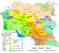
Regions
The constitution divides Cameroon into 10 regions. On 12 November 2008, the President changed the divisions from provinces to regions. Each region is headed by a presidentially appointed governor.
The regions are divided into 58 divisions. These are headed by presidentially appointed divisional officers.
 |
|||||||||||||||||||||||||||||||||||||||||||||||||||||||||||||||||||||||||||||
|
Cities
Some of the largest cities in Cameroon are:
| Ranking | Name | Population |
|---|---|---|
| 1. | Douala | 2,000,000 |
| 2. | Yaoundé | 1,600,000 |
| 3. | Garoua | 450,000 |
| 4. | Bafoussam | 350,000 |
| 5. | Maroua | 327,000 |
| 6. | Bamenda | 299,600 |
| 7. | Ngaoundéré | 185,700 |
Languages
The official languages of Cameroon are French and English. It is part of both the British Commonwealth and La Francophonie. Most people speak French.
Related pages
Images for kids
-
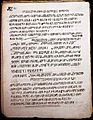
Bamum script is a writing system developed by King Njoya in the late 19th century.
-
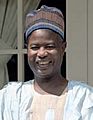
Former president Ahmadou Ahidjo ruled from 1960 until 1982.
-
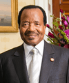
Paul Biya has ruled the country since 1982.
-
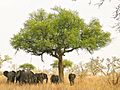
Elephants in Waza National Park
-
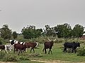
Dutch bulls and cows at Wallya community during the rainy season in Cameroon
-
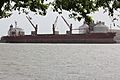
Douala seaport
-
Cameroonian women on Women's Day Celebration
-
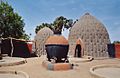
The homes of the Musgum, in the Far North Region, are made of earth and grass.
-
Map of the region's indigenous languages
-
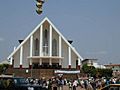
Our Lady of Victories Cathedral, catholic church in Yaoundé
-
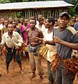
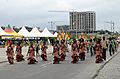
Dancers greet visitors to the East Region.
-
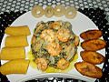
Plantains and "Bobolo" (made from cassava) served with Ndolè (meat and shrimp)
-
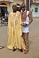
Cameroonian fashion is varied and often mixes modern and traditional elements. Note the wearing of sun glasses, Monk shoes, sandals, and a Smartwatch.
-
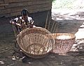
A woman weaves a basket near Lake Ossa, Littoral Region. Cameroonians practise such handicrafts throughout the country.
-
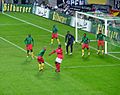
Cameroon faces Germany at Zentralstadion in Leipzig, 17 November 2004.


See also
 In Spanish: Camerún para niños
