
Woolloongabba facts for kids
Quick facts for kids WoolloongabbaBrisbane, Queensland |
|||||||||||||||
|---|---|---|---|---|---|---|---|---|---|---|---|---|---|---|---|
,_1905.JPG)
Former post office on Stanley Street in Woolloongabba
|
|||||||||||||||

Woolloongabba
Location in Queensland
|
|||||||||||||||
| Population | 5,631 (2016 census) | ||||||||||||||
| • Density | 2,250/km2 (5,800/sq mi) | ||||||||||||||
| Postcode(s) | 4102 | ||||||||||||||
| Area | 2.5 km2 (1.0 sq mi) | ||||||||||||||
| Time zone | AEST (UTC+10:00) | ||||||||||||||
| Location | 3.0 km (2 mi) SSE of Brisbane GPO | ||||||||||||||
| LGA(s) | City of Brisbane (The Gabba Ward) |
||||||||||||||
| State electorate(s) | South Brisbane | ||||||||||||||
| Federal Division(s) | Griffith | ||||||||||||||
|
|||||||||||||||
Woolloongabba is a suburb in the City of Brisbane, Queensland, Australia. In the 2016 census, Woolloongabba had a population of 5,631 people.
Contents
Toponymy
Experts are divided regarding the Aboriginal meaning of the name, preferring either 'whirling waters' (woolloon and capemm) or 'fight talk place' (woolloon and gabba).
Because the area was low-lying and swampy, it was known as the One Mile Swamp. Although this name appears to be unofficial, it was in common use until the early 1890s.
History


The suburb has a significant link to the history of transport in Brisbane. Between 1884 and 1969 the main railway locomotive depot for lines south of the Brisbane River was beside Stanley St. It was reached via a line that ran beside Stanley St, then crossing it, Logan Road and Ipswich Road to the main line at Dutton Park. By the 1960s services from the depot were causing significant delays to traffic as they crossed these three major roads.
The suburb was served by horse-drawn trams from 1885 to 1897, which were replaced by electric trams, which in turn ceased operation on 13 April 1969. All but one of Brisbane's trolleybus routes traversed the suburb, from 1953 to 1969. The Woolloongabba Fiveways (the intersection of Stanley Street, Main Street, Logan Road and Ipswich Road) was a complex junction with tram and railway lines, and tram and trolleybus overhead. Trams were controlled by a signalman, who operated the points (or switches) from a signal cabin near the eastern side of the junction. Trains were escorted across the junction by a flagman. Curiously, Queensland Railways always referred to the branch line as the Wooloongabba Branch, spelt with only one 'l'.
From 1927 until 1969 the largest of the Brisbane City Council's tram depots was on Ipswich Road, opposite the Princess Alexandra Hospital. It was also used by the council's buses.
In early 1942 the first Coca-Cola bottling plant in Australia was built in Woolloongabba at 36-39 Balaclava Street. It was originally designed to supply the demands of the newly arrived US military personnel, but later expanded production to the local Australian market.
Attractions


The suburb is home to the Brisbane Cricket Ground known as "The Gabba", and the Princess Alexandra Hospital. Woolloongabba has many apartment buildings due to river views, and the suburb's proximity to the Brisbane central business district and South Bank Parklands. The Norman Hotel is a local landmark that has served customers since 1890. The head office of the Queensland Justices Assosciation is located in Woolloongabba.
Heritage listings
Woolloongabba has a number of heritage-listed sites, including:
- Princess Theatre (8 Annerley Road)
- former Dispenser's House of Diamantina Hospital (Cornwall Street)
- Holy Trinity Anglican Church (68 Hawthorne Street)
- Norman Hotel (102 Ipswich Road)
- former Taylor-Heaslop Building (10-14 Logan Road)
- Broadway Hotel (93 Logan Road)
- the former Woolloongabba Police Station (842-848 Main Street)
- Shop Row (609 & 613 Stanley Street)
- Hillyards Shop House (615 Stanley Street)
- Pollock's Shop House (617-619 Stanley Street)
- Phoenix Buildings (647 Stanley Street)
- the former Woolloongabba Post Office (765 Stanley Street)
- Woolloongabba Air Raid Shelter (34 Sword Street)
Sport and recreation
The suburb is home to the Brisbane Cricket Ground known as "the Gabba".
Demographics
In the 2011 census, the population of Woolloongabba was 4,789, 46.8% female and 53.2% male. The median age of the Woolloongabba population was 31 years, 6 years below the Australian median. 55% of people living in Woolloongabba were born in Australia, compared to the national average of 69.8%; the next most common countries of birth were New Zealand 3.2%, India 3.1%, England 2.8%, Korea, Republic of 2.6%, China 2.5%. 62.6% of people spoke only English at home; the next most common languages were 3.3% Mandarin, 2.8% Vietnamese, 2.5% Korean, 2.1% Cantonese, 1.2% Greek.
Transport
The Pacific Motorway cuts through the suburb with an exit south into Vulture Street and a Stanley Street exit for vehicles heading north. Additionally, there is an entrance to the Clem Jones Tunnel in the suburb on Ipswich road.
Public transport
Trains service the suburb with stops at Park Road railway station and Buranda railway station. The South-East Busway also runs through Woolloongabba, with stops at Woolloongabba Busway Station and Buranda Busway station. The high-frequency Maroon CityGlider bus service also stops here.
Taxis
There is a major taxi depot in Woolloongabba.
Academic Institute
Woolloongabba also has an Institute American College (Brisbane) for Vocational Training and Management courses that is located at logan road.
- Clark, H. and Keenan D6, "Brisbane Tramways – The Last Decade", Transit Press, 1977 (Reprinted 1985). ISBN 0-909338-01-9
- Cole J., "Shaping a City: Greater Brisbane 1925-1985", Brisbane 1984
- Deskins R., Hyde P. and Struble C., "Slow at Frog – A Short History of the Brisbane Trolleybus System", Brisbane Tramway Museum Society, 2006. ISBN 0-9597322-2-5
- Kerr J. and Armstrong J., "Destination South Brisbane", Australian Railway Historical Society, second edition 1984. ISBN 0-909937-09-5
Education
Buranda State School is a government primary (Prep-6) school for boys and girls at 24 Cowley Street (27°29′50″S 153°02′33″E / 27.4971°S 153.0426°E). In 2018, the school had an enrolment of 247 students with 20 teachers (14 full-time equivalent) and 10 non-teaching staff (8 full-time equivalent).
Narbethong State Special School is a special primary and secondary (Early Childhood-12) school for boys and girls at 25 Salisbury Street (27°29′45″S 153°02′41″E / 27.4957°S 153.0447°E). The school specialises in education for students with impaired vision. In 2018, the school had an enrolment of 57 students with 38 teachers (32 full-time equivalent) and 60 non-teaching staff (35 full-time equivalent).
There is no mainstream secondary school in Woolloongabba. The nearest government secondary schools are Brisbane State High School in neighbouring South Brisbane to the north-west, Coorparoo Secondary College in neighbouring Coorparoo to the west, and Yeronga State School in Yeronga to the south.
Images for kids
-
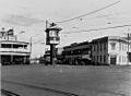
Gabba Fiveways, 1929
-
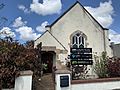
Brisbane Christian Spiritual Alliance Church (former), 2020

