
Pabna District facts for kids
Quick facts for kids
Pabna
পাবনা
|
|
|---|---|
| Motto(s):
"২১ এর চেতনায়,আলোকিত পাবনা!"
|
|

Location of Pabna in Bangladesh
|
|
| Country | |
| Division | Rajshahi Division |
| Pubna District,Bengal Presidency,British India | 1828 |
| Area | |
| • Total | 2,371.50 km2 (915.64 sq mi) |
| flood plain and marsh land | |
| Elevation | 8 m (26 ft) |
| Population
(2019 census)
|
|
| • Total | 3,011,180 |
| • Density | 1,269.736/km2 (3,288.602/sq mi) |
| Literacy rate | |
| • Total | 85% |
| Time zone | UTC+06:00 (BST) |
| Postal code |
6600–6682
|
Pabna District (Bengali: পাবনা জেলা Pabna Zila) is a district in central Bangladesh. It is one of the most valuable district of Bangladesh. Its administrative capital is the eponymous Pabna town.
Contents
History
Archeologist Cunningham conjectured that the name Pabna might be derived from Pundra or Poondrobordhon civilisation, whose capital was Mahasthangarh, the oldest city of Bangladesh, in neighbouring Bogra. But this hypothesis has not received general acceptance among scholars.
In 1859–61 the district was one of the major areas involved in the Indigo revolt. Beginning in Yusufshahi period in 1873 the serfs resisted excessive demands of increased rents by feudal lords (zamindar), led by the nouveau riches Banerjees and Dwijendranath Tagore, by forming an Agrarian League. This largely peaceful movement found the support of the Lieutenant-Governor of Bengal George Campbell, who antagonised the absentee feudal lords. These protests are generally referred to as Pabna disturbances. In the following year the district was one of the worst hit by famine. The peasant's demands were finally partially met with the Rent Law Act of 1885.
In 1875, Raaygonj was transferred back to Pabna from Bogra, and in 1879, a separate judgeship for the districts of Pabna and Bogra was created. The History of Pabna was written by Advocate Chowdhury Mohammad Badruduzza.
Geography
Pabna forms the south-east boundary of Rajshahi Division. Sirajganj District is on the north-east, while the Padma River, main stream of the holy river Ganges, in the south separates it from Rajbari District and Kushtia District. The Jamuna River runs along its eastern border separating it from Manikgonj District; and on the north-west it has a common boundary with the Natore District. Average maximum temperature 36.8 °C, minimum 9.6 °C; annual rainfall 1872 mm. Characteristically the soil of the district is divided into four, viz flood plains of the Ganges, Karatoya, Jamuna and Barind Tract. Main rivers are Ganges, Ichamati, Gumani, Baral and Hurasagar.
Images for kids
-
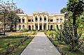
Tarash Palace
-
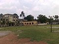
Pabna Zilla School


See also
 In Spanish: Pabna (zila) para niños
