Running Creek, Queensland facts for kids
Quick facts for kids Running CreekQueensland |
|||||||||||||||
|---|---|---|---|---|---|---|---|---|---|---|---|---|---|---|---|

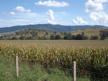
McPherson Range and corn crop, 2016
|
|||||||||||||||
| Population | 146 (2021 census) | ||||||||||||||
| • Density | 1.299/km2 (3.36/sq mi) | ||||||||||||||
| Postcode(s) | 4287 | ||||||||||||||
| Area | 112.4 km2 (43.4 sq mi) | ||||||||||||||
| Time zone | AEST (UTC+10:00) | ||||||||||||||
| Location |
|
||||||||||||||
| LGA(s) | Scenic Rim Region | ||||||||||||||
| State electorate(s) | Scenic Rim | ||||||||||||||
| Federal Division(s) | Wright | ||||||||||||||
|
|||||||||||||||
Running Creek is a small countryside area, also known as a locality, in the Scenic Rim Region of Queensland, Australia. It's located right next to the border of New South Wales. In 2021, about 146 people lived in Running Creek.
Contents
Exploring Running Creek's Geography
Running Creek is a beautiful area with lots of natural features.
Mountains and Valleys
The southern part of Running Creek is bordered by the McPherson Range, a mountain range that forms the border between Queensland and New South Wales.
The area gets its name from Running Creek, a stream that starts in Lamington. This creek flows north through the locality and then joins the Logan River. Other smaller streams like New Year Creek and Camp Creek also flow into Running Creek.
Running Creek is home to several mountains:
- Grass Tree Knob (28°18′34″S 152°59′06″E / 28.3095°S 152.9850°E) is 524 metres (1,719 feet) tall.
- Lawn Hill (28°17′00″S 152°57′10″E / 28.2834°S 152.9529°E) is 454 metres (1,490 feet) tall.
- Mount Chinghee (28°18′01″S 152°57′27″E / 28.3003°S 152.9576°E) is 773 metres (2,536 feet) tall.
There are also mountain passes, which are gaps or low points in the mountains that make it easier to travel through:
- Gradys Gap Gate (28°19′56″S 152°57′51″E / 28.3321°S 152.9643°E)
- Richmond Gap (28°19′55″S 152°58′22″E / 28.3319°S 152.9729°E)
Neighbourhoods in Running Creek
Running Creek has a few smaller areas within it, called neighbourhoods:
- Dulbolla (28°12′51″S 152°52′53″E / 28.2141°S 152.8813°E)
- Glenapp (28°16′24″S 152°54′25″E / 28.2733°S 152.9069°E)
- Waiweer (28°18′34″S 152°53′51″E / 28.3094°S 152.8975°E)
Mount Chinghee National Park
Mount Chinghee National Park (28°18′01″S 152°56′51″E / 28.3003°S 152.9475°E) is located in the southeast part of Running Creek. This national park is a protected area. It helps to keep the natural rainforest safe and provides a home for many animals. There are no walking paths or visitor areas in the park, as its main purpose is to protect nature.
Railways and Roads
The main railway line that connects Sydney to Brisbane runs through Running Creek from north to south. Near the border, the railway goes into a tunnel and then through a special looping section called the Cougal Spiral.
The Lions Road also passes through Richmond Gap, connecting Running Creek to Cougal in New South Wales.
Running Creek's History
Running Creek has a rich history, especially with timber and railways.
Early Industries and Schools
In the early days, cutting timber was a very important business here. There used to be sawmills in Running Creek and Glenapp, where logs were cut into planks. These sawmills are no longer there today.
A school called Glenapp Provisional School opened on August 19, 1901. It later became Glenapp State School in 1909. However, it closed down on December 9, 1960. The school was located on the eastern side of Running Creek Road.
Railways and Tramways
The Beaudesert Shire Tramway was a special railway that ran from Beaudesert to Rathdowney and Lamington. It operated from 1903 to 1944. There was a stop in Running Creek called Dulbolla station (28°12′51″S 152°52′58″E / 28.2142°S 152.8828°E).
The Glenapp railway signal box (28°17′04″S 152°54′21″E / 28.2845°S 152.9057°E) is a small hut located next to the Brisbane-to-Sydney railway line in Running Creek. It was built in 1930 and is one of the few left that are still in good condition. Signal boxes were used to control train movements. When new technology made it unnecessary, the signal box was almost taken down in 2007. But two local men, Den and Rob Sibson, who grew up in Glenapp, decided to save and fix it up. They turned it into a small museum! The old Glenapp railway siding, which was a side track for trains, was moved to the Rathdowney Historical Museum.
National Park Establishment
Telemon Environment Park, which we now know as Mount Chinghee National Park, was officially made a protected area in 1994.
Population of Running Creek
The number of people living in Running Creek has changed a little over the years.
- In 2011, Running Creek and nearby areas had a population of 463 people.
- In 2016, Running Creek had a population of 147 people.
- In 2021, the population was 146 people.
Education Opportunities
There are no schools directly in Running Creek. For primary school, students usually go to Rathdowney State School, which is in the nearby area of Rathdowney. For high school, students typically attend Beaudesert State High School in Beaudesert.
 | Leon Lynch |
 | Milton P. Webster |
 | Ferdinand Smith |


