
Saint Heliers facts for kids
Quick facts for kids Saint Heliers |
|
|---|---|

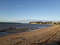
View of St Heliers Beach towards Achilles Point
|
|
| Basic information | |
| Local authority | Auckland Council |
| Electoral ward | Ōrākei Ward |
| Population | 11529 (2018) |
| Surrounds | |
| North | (Hauraki Gulf), Rangitoto Island |
| Northeast | Browns Island |
| East | Glendowie |
| Southeast | Wai o Taiki Bay |
| South | Glen Innes |
| Southwest | Saint Johns |
| West | Kohimarama, Mission Bay |
| Northwest | Ōrākei |
Saint Heliers is an affluent seaside suburb of Auckland with a population of 4824. This suburb is popular amongst visitors for the beaches, cafés, and views of Rangitoto Island, the distinctive volcanic island in the Hauraki Gulf.
St. Heliers is located at the eastern end of Tamaki Drive, and used to be the place where the Tamaki estuary formally divided Auckland from Manukau City, until the entire Auckland region was amalgamated under a single city authority, the Auckland Council, in 2010. Local government of St. Heliers is the responsibility of the Ōrākei Local Board, which also covers the suburbs of Ōrākei, Kohimarama, Mission Bay, Glendowie, St Johns, Meadowbank, Remuera and Ellerslie.
Contents
History
Glen Orchard
European settlement began on the north-facing slopes of St. Heliers bay, with the establishment of the Glen Orchard homestead, believed to have been built in the 1850s. The building was recognised as a place of historic, architectural and social significance by Heritage New Zealand in October 2010. This Regency-style residence incorporates Italianate influences, and has a grand and elegant appearance. Glen Orchard is a historic example of a prosperous rural homestead, and is linked to the settlers who comprised Auckland’s early elite. It is known as the residence of Lieutenant-General William Taylor (1790-1868), and his son Charles, who married into the family of the fourth New Zealand Premier, Alfred Domett. William Taylor was a retired senior officer of the East India Company’s Madras Army.
In 1879 Glen Orchard became Auckland’s first stud farm, managed by Major Walmsley, who suggested the name St. Heliers Bay, supposedly because it reminded him of the fashionable holiday resort Bay of Saint Helier, in Jersey one of Britain’s Channel Islands. In the mid-1880s the homestead became the centre piece of a planned model seaside suburb that was the foundation of present day St. Heliers.
Transport
In November 1881 St. Heliers Bay was bought by the St. Heliers and Northcote Land Company. The aim of this company was to make the land available for residential development. The company realized the area would be more attractive for potential future buyers if St. Heliers’ connections to the Auckland’s town centre were improved. At that time St Heliers was usually reached by boat, the trip from Auckland taking only 30 minutes, whereas the 13 km (eight mile) land route via Newmarket, Remuera and Meadowbank was usually much more onerous. During this period St Heliers was a centre for local farmers and the location of the villas of a few rich business people. Despite advertisements in the New Zealand Herald, such as the example below, ultimately land sales were poor and the companies scheme failed:
“To visit St. Heliers Bay, formerly Glen Orchard, is to become impressed with the fact that there is no other bay of equal beauty near Auckland. It commands a charming and picturesque view of the North Shore, Rangitoto, Motutapu and Brown’s Island. The beach is so attractive that it cannot fail to be resorted to as a fashionable watering-place. The soil is partly volcanic and is a warm rich loam which, for orchards and floriculture, leaves little to be desired. It will be seen that the land slopes to the north with hills behind as protection from chilly southern winds; therefore the aspect is an especially favourable one for fruit growing and successful gardening. We may fairly say that with regular and frequent communication by means of tramway, or steamer to the new wharf, it requires no stretch of the imagination to believe that that beautiful bay will become the Brighton of Auckland“.
The advertisement indicates the need for better transport links. The St. Heliers and Northcote Land Company built a 460m (1500 foot) piet at St. Heliers in 1882 before becoming insolvent. However, the tramway connection to Auckland was never realized. By 1890 St. Heliers had become a popular waterfront destination for day trippers, with excursions running from Auckland and Thames. Moonlight excursions from Auckland were especially popular. For this particular excursion the Eagle and Osprey boats where used, since they allowed dancing on board.
After Tamaki Drive was opened in 1931 St. Heliers became a commuter suburb and a destination for Sunday drives. The wharf is long gone but there is frequently talk of rebuilding it, whenever Tamaki Drive is gridlocked with traffic.
Landmarks & Features
Achilles Point
Achilles Point is regarded as the rocky promontory on the east side of Ladies Bay, but the name can also indicate the whole headland between St. Heliers and the Tamaki River estuary. It offers great views of the Waitematā Harbour, and the Gulf Islands. The area used to be called Te Pane O Horoiwi (the head of Horoiwi), after one of the chiefs of the Tanui canoe. In 1940 it was named Achilles Point in honour of the New Zealand battleship HMS Achilles and her crew. The Achilles opened fire on the German cruiser Admiral Graf Spee in the South Atlantic on 13 December 1939. In doing so she became the first New Zealand unit to strike a blow at the enemy in World War II, and the first New Zealand warship to take part in a naval battle. This confrontation off Argentina was later called Battle of the River Plate,

the first major naval engagement of World War II, during which the Achilles, defeated the Admiral Graf Spee.
Parks
Dingle Dell Reserve - In the 1950s Dingle Dell Reserve was described as the forgotten "Cinderella of Auckland’s Parks" in the New Zealand Herald. Today it is still a peaceful area located in the heart of St. Heliers, where people can enjoy a picnic or bush walk. The park hosts, amongst others, the native plants kohekohe and tanekaha, which are the results of native plantings undertaken in 1933. Dingle Dell was part of Major Thomas Bunbury’s four farms, which he bought in 1842. It became a public reserve in 1930 and is now owned and managed by the Auckland Council.
Glover Park - St Heliers has one relatively unknown volcano, a maar of unknown age. Its crater had formed a swamp by the time European settlers arrived in the area. On the seaward side, a Māori defended settlement pā has once stood, and the landward side is marked by the water tower at its highest point. The Auckland City Council acquired the land in the 1930s and in 1953 half the area was drained and consolidated. In the same year the Tamaki Ex-Servicemen’s Women’s Auxiliary planted trees to commemorate the men of the district who had lost their lives during World War II. Unfortunately the drainage project of 1953 proved a failure because the area remained unstable and susceptible to flooding. Additional drainage in 1959 made the park a safe and respectable reserve and allowed the area to be converted into the sports fields of Glover Park. It is unclear whether the trees that were planted in 1953 are still the same trees present in Glover Park today.
Events
Weet-Bix Kids TRYathlon Park – New Zealand’s first triathlon for children was held at St. Heliers in 1992 and attracted approximately 500 participants. Children compete over distances starting with a 50-metre swim, 4-kilometre cycle and 1-kilometre run. Since 1992 this event has grown considerably with 20,000 children competing in one of the 13 TRYathlons around the country in 2013.
Round The Bays Fun Run – This annual event is the result of the international running boom of the 1970s and 1980s, during which millions of people took up running. The Auckland Round the Bays Fun Run is one of the largest in the world, and was initiated by the Auckland Joggers Club in the early 1970s. The run is 8.4 km long over Tamaki Drive, the flat road following the contours of the Waitematā Harbour, passing Hobson Bay, Ōkahu Bay, Mission Bay, Kohimarama Beach, and finishing in St. Heliers Bay Reserve. Nowadays it is estimated that between 70,000 and 80,000 runners participate each year.
Gallery
-
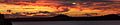
Waitematā Harbour at sunset, taken from the point between Kohimarama and St. Heliers Beaches
-
The suburb is relatively affluent, and includes some houses in styles rarely seen elsewhere in New Zealand
-
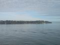
Waterview of St. Heliers


Demographics
| Historical population | ||
|---|---|---|
| Year | Pop. | ±% p.a. |
| 2006 | 10,584 | — |
| 2013 | 10,998 | +0.55% |
| 2018 | 11,529 | +0.95% |

Saint Heliers, comprising the statistical areas of Saint Heliers West, Saint Heliers North and Saint Heliers South, had a population of 11,529 at the 2018 New Zealand census, an increase of 531 people (4.8%) since the 2013 census, and an increase of 945 people (8.9%) since the 2006 census. There were 4,341 households. There were 5,475 males and 6,051 females, giving a sex ratio of 0.9 males per female, with 2,091 people (18.1%) aged under 15 years, 1,635 (14.2%) aged 15 to 29, 5,397 (46.8%) aged 30 to 64, and 2,409 (20.9%) aged 65 or older.
Ethnicities were 84.0% European/Pākehā, 4.2% Māori, 1.5% Pacific peoples, 13.9% Asian, and 3.0% other ethnicities (totals add to more than 100% since people could identify with multiple ethnicities).
The proportion of people born overseas was 35.8%, compared with 27.1% nationally.
Although some people objected to giving their religion, 44.4% had no religion, 44.8% were Christian, and 5.3% had other religions.
Of those at least 15 years old, 4,260 (45.1%) people had a bachelor or higher degree, and 606 (6.4%) people had no formal qualifications. The employment status of those at least 15 was that 4,560 (48.3%) people were employed full-time, 1,500 (15.9%) were part-time, and 237 (2.5%) were unemployed.
Education
St Heliers School is a full primary school (years 1–8) with a roll of 580.
St Ignatius Catholic School is a state-integrated contributing primary school (years 1–6) with a roll of 206.
Both these schools are coeducational. Rolls are as of April 2023.
Images for kids
-
St Heliers Beach in Auckland
-
Shop window display of a shoe shop in St Heliers in Auckland
-
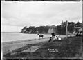
View of the eastern end of St Heliers Bay. Photographed by William Archer Price between 1910 and 1930.
-
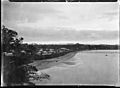
View of St Heliers Bay, Auckland, looking west. The wharf is in the middle distance. Photographed by William Archer Price between 1910 and 1930.


.jpg)
.jpg)
