
Salvaleón de Higüey facts for kids
Quick facts for kids
Higüey
|
||
|---|---|---|
|
Municipality
|
||
| Salvaleón de Higüey | ||

Nuestra Señora de la Altagracia basilica
|
||
|
||
| Country | ||
| Province | La Altagracia | |
| Municipal Districts | 3 | |
| Founded | 1503 | |
| Municipality since | 1844 |
|
| Area | ||
| • Total | 907.7 km2 (350.5 sq mi) | |
| • Urban | 27.93 km2 (10.78 sq mi) | |
| Elevation | 106 m (348 ft) | |
| Population
(2014)
|
||
| • Total | 168,501 | |
| • Density | 185.635/km2 (480.793/sq mi) | |
| • Urban | 147,978 | |
| Demonym(s) | Higüeyano (female, higüeyana) |
|
| Time zone | UTC-4 (AST) | |
| • Summer (DST) | UTC-4 (AST) | |
| Distance | 35 km (22 mi) to La Romana 145 km (90 mi) to Santo Domingo] |
|

The Dominican city of Salvaleón de Higüey, usually known as Higüey, is the head municipality of the La Altagracia province, on the eastern part of the country.
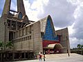
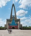
The Basílica de Nuestra Señora de la Altagracia ("Our Lady of High Grace Basilica"), a cathedral, is in this city and many Catholic people come here to pray.
Contents
Population
The municipality had, in 2010, a total population of 168,501: 84,562 men and 83,939 women. The urban population was 87.8% of the total population, one of the most urban municipality in the country.
History
The city was founded by Juan de Esquivel in 1503. Higüey was the Taíno name of the eastern part of the island.
Geography
The municipality of Salvaleón de Higüey has a total area of 907.7 km2 (350.5 sq mi). It has three municipal districts (a municipal district is a subdivision of a municipality). These are Las Lagunas de Nisibón, La Otra Banda and Verón Punta Cana.
Higüey is at 145 km (90 mi) to the east of Santo Domingo and at 35 km (22 mi) to the north of La Romana. The municipality is in the region known as Llano Costero del Caribe ("Caribbean Coastal Plain"), in the eastern part of the country, a region with many savannas.
The altitude of the city of Higüey is 106 m (348 ft) above sea level.
The municipality of Higüey has the Atlantic Ocean to the north and east, the municipality of San Rafael del Yuma to the south, the La Romana province to the southwest and the El Seibo province to the west.
Climate
Higüey has a tropical wet climate (Köppen climate classification : Af) with no dry or cold season as it is constantly moist.
The average amount of rainfall for the year in the city is 1,423.2 mm (56.0 in). The month with the most precipitation on average is May with 183.1 mm (7.2 in) of rainfall, followed by October with 160 mm (6.3 in).
The driest season is winter. The month with the least rainfall on average is February with an average of 66.8 mm (2.6 in) and the second is March with 71.6 mm (2.8 in).
Higüey is in a warm region; the average temperature for the year is 26.4 °C (80 °F). The warmest month, on average, is July with an average temperature of 27.85 °C (82.1 °F). The coolest month on average is January, with an average temperature of 24.55 °C (76.19 °F).
| Climate data for Higüey (1961–1990) | |||||||||||||
|---|---|---|---|---|---|---|---|---|---|---|---|---|---|
| Month | Jan | Feb | Mar | Apr | May | Jun | Jul | Aug | Sep | Oct | Nov | Dec | Year |
| Average high °C (°F) | 29.1 (84.4) |
29.3 (84.7) |
30.2 (86.4) |
30.7 (87.3) |
31.2 (88.2) |
32.2 (90.0) |
32.4 (90.3) |
32.4 (90.3) |
32.5 (90.5) |
32 (90) |
30.7 (87.3) |
29.1 (84.4) |
31.0 (87.8) |
| Daily mean °C (°F) | 24.6 (76.3) |
24.6 (76.3) |
25.3 (77.5) |
25.9 (78.6) |
26.7 (80.1) |
27.6 (81.7) |
27.9 (82.2) |
27.9 (82.2) |
27.8 (82.0) |
27.2 (81.0) |
26.2 (79.2) |
24.9 (76.8) |
26.4 (79.5) |
| Average low °C (°F) | 20 (68) |
19.9 (67.8) |
20.3 (68.5) |
21.1 (70.0) |
22.1 (71.8) |
23 (73) |
23.3 (73.9) |
23.3 (73.9) |
23 (73) |
22.4 (72.3) |
21.6 (70.9) |
20.7 (69.3) |
21.7 (71.0) |
| Average rainfall mm (inches) | 75.6 (2.98) |
66.8 (2.63) |
71.6 (2.82) |
105.3 (4.15) |
183.1 (7.21) |
101.3 (3.99) |
117.9 (4.64) |
141.2 (5.56) |
134.4 (5.29) |
160 (6.3) |
152.1 (5.99) |
113.9 (4.48) |
1,423.2 (56.04) |
| Source 1: NOAA | |||||||||||||
| Source 2: Climatemps.com | |||||||||||||
Administrative division
The municipality of Higüey has three municipal districts:
| Code | Municipal district | Population (2010) |
|---|---|---|
| 110102 | Las Lagunas de Nisibón | 9,831 |
| 110103 | La Otra Banda | 28,929 |
| 110104 | Verón Punta Cana | 43,982 |
Economy
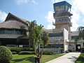
The most important economic activity in the municipality is tourism, along the eastern coast, mainly in Bávaro and Punta Cana.
But farming is still an important activity in the rest of the municipality, mainly cattle raising. Also sugarcane is a very important crop in this municipality.
| Provincial capitals of the Dominican Republic | |
|---|---|
| Azua • Baní • Barahona • Bonao • Comendador • Cotuí • Dajabón • El Seibo • Hato Mayor • Higüey • Jimaní • La Romana • La Vega • Mao • Moca • Monte Cristi • Monte Plata • Nagua • Neiba • Pedernales • Puerto Plata • Sabaneta • Salcedo • Samaná • San Cristóbal • San Francisco de Macorís • San José de Ocoa • San Juan de la Maguana • San Pedro de Macorís • Santiago de los Caballeros • Santo Domingo • Santo Domingo Este | |
Images for kids
-
Higuey, Dominican Republic.
-

Tourism of Higüey-Punta Cana
-
Basilica de La Altagracia
-
Punta Cana, Dominican Republic airport terminal.


See also
 In Spanish: Higüey para niños
