
Shadyside (Pittsburgh) facts for kids
Quick facts for kids
Shadyside
|
|
|---|---|
|
Neighborhood of Pittsburgh
|
|

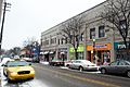
Street in Shadyside, 2001
|
|
 |
|
| Country | United States |
| State | Pennsylvania |
| County | Allegheny County |
| City | Pittsburgh |
| Area | |
| • Total | 0.921 sq mi (2.39 km2) |
| Population
(2010)
|
|
| • Total | 13,915 |
| • Density | 15,109/sq mi (5,833/km2) |
Shadyside is a neighborhood in the East End of Pittsburgh, Pennsylvania, United States. It has three zip codes (15206, 15213, and 15232) and representation on Pittsburgh City Council by the council member for District 8 (East Central Neighborhoods). Shadyside is drawn from the name of a 19th-century Pennsylvania Railroad station in the area, which was named for its shady lanes.
Another neighborhood institution is Shadyside Hospital, a member of the University of Pittsburgh Medical Center. Chatham University is located just across the southern edge of the neighborhood in Squirrel Hill, along with Pittsburgh Center for the Arts, which is also a part of Mellon Park. (A portion of Mellon Park is located in Shadyside as well as the Point Breeze neighborhood.)
In April 2014, Niche rated Shadyside the best neighborhood in Pittsburgh for millennials (Pittsburgh ranked 15th among cities nationally in the same study).
Residential Shadyside
Since the 1920s, residential Shadyside has been home to a mix of affluent families, young professionals, artists, musicians, students, and apartment dwellers. The residential areas of the neighborhood include Victorian mansions along with modern apartments and condominiums. The neighborhood has a compact layout, which prevents most houses from having garages. Public transportation is available via Port Authority bus system; express busway stops are located in the neighborhood on Negley Avenue (between Ellsworth and Centre avenues) and on Ellsworth Avenue (at Shady Avenue).
Shadyside Action Coalition
The Shadyside Action Coalition, known colloquially as SAC, is a community organization. This not-for-profit organization was formed in 1973. According to their website, their goals are to, "preserve values and laws of this community"; the issues they have chosen to focus on are "neighborhood safety, planning and zoning, parking, quality of life, preserving the character of the community, and being actively involved with the future development of our community". Composed of 34 organizations, book clubs, and churches, SAC has "sought to be the instrument through which Shadyside could control its own destiny, mainly by generating sufficient power to influence forces such as government planners, larger property investors, banks, and school boards".
Within the larger Shadyside Action Coalition, there are six different committees: community networking, fundraising, historic Shadyside, membership, public safety, and zoning. Community networking's stated goal is to, "maintain collaborative relationships with adjacent community groups to work on shared projects along borders". They are involved with liaisons in many other neighborhoods around Pittsburgh. These neighborhoods include East Liberty, North Point Breeze, South Point Breeze, Bloomfield, Friendship, Oakland, and Squirrel Hill. Projects that are being worked on as of 2010 are the Baum Centre Initiative and Bakery Row.
The Baum Centre Initiative is a project with the goal of, "developing a cohesive, renewed, and thriving Baum-Centre Corridor". The Baum-Centre Corridor is a section of UPMC Shadyside, and there has been much debate surrounding this project. Concerns include whether this project constitutes an expansion of UPMC Shadyside or if it is a transformation of the building that is already there. The project has encountered some legal and legislative problems.
Bakery Row is a collaborative effort with East Liberty Development Inc. and SAC to develop the "Bakery Row" section of Penn Ave. Seven districts converge at Bakery Row: East Liberty. Homewood, North Point Breeze, South Point Breeze, Squirrel Hill, Shadyside, and Larimer. Plans include development of Penn and Shady, the resurrection of an East Liberty Station, reopening the Reizenstein Middle School, redevelopment of buildings in "Bakery Square", creating more pedestrian-friendly transportation, as well as more "transit-oriented" transportation.
Other projects the community networking committee has worked on include the Pedestrian Bridge, the Doc Economou project, UPMC's Cromisa halfway house, Chipotle Mexican Grill, Fidelity Bank on Centre, Hertz on Baum and Bobby Rahal's on Baum.
SAC has one annual fundraiser- the house tour. According to their website all of the money raised through this event is put into the community. In 2010 the funds were utilized for scholarships for summer arts camps at Shadyside Center For the Arts, bike racks, block watch signs and safety programs, an architect/zoning real estate attorney opinion about a neighborhood issue, "Welcome to the Neighborhood" packets for new people in the area, and the creation of a quarterly newsletter. In 2010, for the 32nd annual house tour, people went through eight homes on a self-guided tour. Transportation from each private home was provided by Molly's Trolley's.
History
Shadyside was originally named after a local farm, and was annexed to Pittsburgh in 1868.
Gallery
-
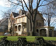
Sellers House, built in 1858, at 400 Shady Avenue.
-
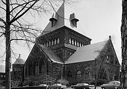
Shadyside Presbyterian Church, built in 1889, at 5121 Westminster Place (at the corner of Amberson Avenue and Westminster Place).
-
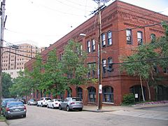
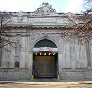
Bindley Hardware Company Building, built in 1903, at 401 Amberson Avenue.
-
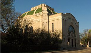
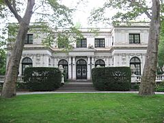
Rodef Shalom Temple, built in 1906, at 4905 5th Avenue.
-
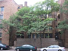
Highland Towers Apartments, built in 1913, at 340 South Highland Avenue.
-
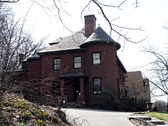
Negley-Gwinner-Harter House, built in 1870 and 1871, at 5061 Fifth Avenue.
-
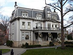
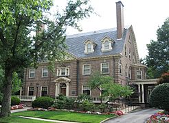
Moreland-Hoffstot House, built in 1914, at 5057 Fifth Avenue.
-
Hunt Armory, built in 1916, at 324 Emerson Street.
-
Harvey Childs House, built in 1896, at 718 Devonshire Street.
-
Sunnyledge, built in 1886, at 5124 Fifth Avenue.
-
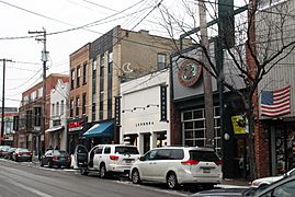
Retailers along Walnut Street.
-
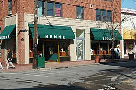
The Henne Jewelers storefront in 2005.


Images for kids
-
Storefronts along South Highland Avenue.
-
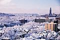
Shadyside in winter


