
Tajikistan facts for kids
Quick facts for kids
Republic of Tajikistan
Ҷумҳурии Тоҷикистон
Cumhuriyi Tocikiston |
|
|---|---|
 Emblem
|
|
|
Anthem: Surudi Milli
National anthem of Tajikistan |
|
.svg) |
|
| Capital and largest city
|
Dushanbe |
| Official languages | Tajik (Persian) (state) |
| Recognised regional languages | Russian (inter-ethnic communication) |
| Ethnic groups
(2000)
|
Tajik 79.9% Uzbek 15.3% Russian 1.1% Kyrgyz 1.1% other 2.6% |
| Demonym(s) | Tajikistani |
| Government | Unitary semi-presidential republic |
|
• President
|
Siyovush Mirzoev |
|
• Prime Minister
|
Habibullo Abdualimov |
| Independence (from the Soviet Union) | |
|
• Establishment of the Samanid Empire
|
875 AD |
|
• Declared
|
September 9, 1991 |
|
• Completed
|
December 25, 1991 |
| Area | |
|
• Total
|
143,100 km2 (55,300 sq mi) (102nd) |
|
• Water (%)
|
1.8 |
| Population | |
|
• 2011 estimate
|
7,616,000 (98th) |
|
• 2000 census
|
6,127,000 |
|
• Density
|
48.6/km2 (125.9/sq mi) (155th) |
| GDP (PPP) | 2010 estimate |
|
• Total
|
$14.311 billion |
|
• Per capita
|
$32,190 |
| GDP (nominal) | 2013 estimate |
|
• Total
|
$84.982 billion |
|
• Per capita
|
$1767 |
| Gini (2004) | 33.59 medium |
| HDI (2011) | medium · 127th |
| Currency | Somoni (TJS) |
| Time zone | UTC+5 (TJT) |
| Driving side | right |
| Calling code | 992 |
| ISO 3166 code | TJ |
| Internet TLD | .tj |
|
|

Tajikistan is a country in South-central Asia. It was previously part of the Soviet Union. Tajikistan is a republic. The capital city is Dushanbe. The official language is Tajik,which is a dialect of Farsi (Persian).
Tajikistan is a member of the Commonwealth of Independent States, the CIS. Tajikistan is eighth in size of CIS countries.
Contents
Geography
Tajikistan is one of the new countries in South-central Asia. It is west of China, north of Afghanistan and Pakistan, that is separated by a narrow 14 km strip of Tajik claimed land known as the Wakhan Corridor in the Pamirs, east of Uzbekistan and south of Kyrgyzstan.
Tajikistan is landlocked in the middle of the continent of Asia.
Its total area is only about 143,100 square kilometres (55,300 sq mi). It is slightly smaller than Wisconsin, USA. Tajikistan’s borders total to 3,651 kilometres (2,269 mi) long.


The climate has hot summers and mild winters.
Almost all of the country (85 percent) is mountainous with river-valleys running across, however high altitude mountains of Pomir are in the eastern part of the country, (which is the west end of the Himalayas). The climate there is semiarid to polar. The mountains cover an area of about 120,000 km2 (46,000 sq mi). There are other countries within the mountain range. The mountains are between 3,600 to 4,400 metres (11,800 to 14,400 ft) high.
Karakul lake is located within a 52-kilometre-wide (32 mi) meteorite crater, which would have formed about 25 million years ago, or less than 5 million years ago.
History
The land that is now Tajikistan has been lived in since 4,000 BC. It has been under the rule of various empires throughout history, mostly the Persian Empires.
In the year 800, Islam came to Tajikistan.
In 1868, Tajikistan became a Russian Colony. It later became a part of the Soviet Union .
On 9 September 1991, after long periods of mass protests against Soviet Government, the Parliament of Tajikistan declared independence from Soviet Union, and held first presidential elections.
Rahmon Nabiev, who ran the country during Soviet Union in the late 1970s and early 1980s, become its president. He was unable to bring any much needed reforms to the country, and so there were protests in the capital city, Dushanbe. The government responded by organising a pro-government demonstration, mainly made of old Communist Party members and people from the southeast of the country brought to the city. Anti-government protests did not stop, so the government gave weapons to the pro-government demonstrator. Then the Opposition armed themselves.
After this bloody civil war broke out. In which all of the new democratic parties, political organisations and movements together with the political Islamic movements created an alliance, opposing the old communist government and southerners.
After the September 11, 2001 attacks, many American and French Soldiers came into the country.
Provinces
Tajikistan is divided into 4 provinces.
| Division | ISO 3166-2 | Capital | Area (km²) | Pop (2008) |
|---|---|---|---|---|
| Sughd | TJ-SU | Khujand | 25,400 | 2,132,100 |
| Region of Republican Subordination | TJ-RR | Dushanbe | 28,600 | 1,606,900 |
| Khatlon | TJ-KT | Qurghonteppa | 24,800 | 2,579,300 |
| Gorno-Badakhshan | TJ-BG | Khorugh | 64,200 | 218,000 |
Images for kids
-
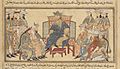
The Samanid ruler Mansur I (961–976).
-
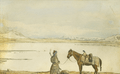
19th-century painting of lake Zorkul and a local Tajik inhabitant.
-
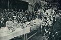
Soviet negotiations with basmachi, 1921
-
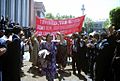
Tajik men and women rally on Ozodi square in Dushanbe shortly after independence, 1992.
-
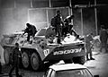
Spetsnaz soldiers during the civil war, 1992.
-
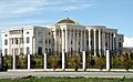
The Palace of Nations in Dushanbe.
-
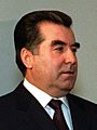
President of Tajikistan, Emomali Rahmon, has ruled the country since 1994.
-
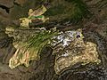
Satellite photograph of Tajikistan
-
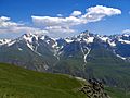
Mountains of Tajikistan
-
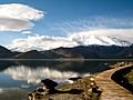
Karakul lake
-
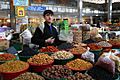
A Tajik dry fruit seller
-
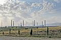
The TadAZ aluminium smelting plant, in Tursunzoda, is the largest aluminium manufacturing plant in Central Asia, and Tajikistan's chief industrial asset.
-
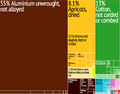
Graphical depiction of Tajikistan's product exports in 28 colour-coded categories.
-
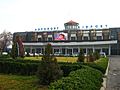
The old terminal building at Dushanbe International Airport
-
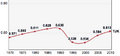
Tajikistan: trends in its Human Development Index indicator 1970–2010
-
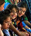
Group of Tajik children
-
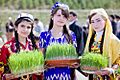
Tajik young women during Navrūz (Persian New Year). They are holding sprouting plants which symbolize rebirth.
-
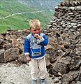
Yaghnobi boy
-
A mosque in Isfara, Tajikistan
-
A hospital in Dushanbe
-
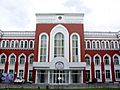
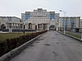
Tajik National University in Dushanbe.
-
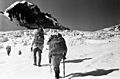
Tajikistan is a popular destination amongst mountaineers. 1982 expedition to Tartu Ülikool 350.


.jpg)


.jpg)
.jpg)
See also
 In Spanish: Tayikistán para niños
