
Brooksville, Maine facts for kids
Quick facts for kids
Brooksville, Maine
|
|
|---|---|

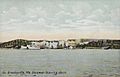
View of Buck's Harbor c. 1910
|
|

Brooksville, Maine
Location in Maine

Brooksville, Maine
Location in the United States
|
|
| Country | United States |
| State | Maine |
| County | Hancock |
| Incorporated | 1817 |
| Villages | Brooksville Harborside Herricks North Brooksville Norumbega South Brooksville West Brooksville |
| Area | |
| • Total | 51.12 sq mi (132.40 km2) |
| • Land | 31.13 sq mi (80.63 km2) |
| • Water | 19.99 sq mi (51.77 km2) |
| Elevation | 131 ft (40 m) |
| Population
(2020)
|
|
| • Total | 935 |
| • Density | 30/sq mi (11.6/km2) |
| Time zone | UTC-5 (Eastern (EST)) |
| • Summer (DST) | UTC-4 (EDT) |
| ZIP code |
04617
|
| Area code(s) | 207 |
| FIPS code | 23-07975 |
| GNIS feature ID | 0582372 |
Brooksville is a town on Penobscot Bay in Hancock County, Maine, United States. As of the 2020 census, the town population was 935. It contains the villages of North Brooksville, South Brooksville (on Buck's Harbor), West Brooksville, Brooksville Corner, and Harborside (on Cape Rosier).
Contents
History
It was first settled by John Wasson, Samuel Wasson and David Hawes, soldiers in the Revolutionary War. Incorporated on June 13, 1817, the town was formed from parts of Castine, Penobscot and Sedgwick. It was named Brooksville after Governor John Brooks of Massachusetts, which then governed Maine.
The surface of the town abounds with granite, and several quarries were established. The soil is a clay loam, which yielded wheat and potatoes. Buck's Harbor, safe and deep, is one of the best coves in the region for small boats, and many residents became involved in the coasting trade and fisheries. By 1880, when the population was 1,419, Brooksville had a porgy oil factory, two sawmills, a shingle mill, a planing mill, two gristmills, a wool carding mill, and a cloth and yarn factory. Shipping was an industry, with ship repairs done at the foot of Wasson's Wharf Road with a pier to the channel in the Bagaduce. There was a brickyard, blacksmith's shop, rope walk and small store for provisions. As late as 1912, there were 18 schooners at the wharf under repair. A small packet, the Goldenrod, ferried passengers from Brooksville to Castine and there was a pier to the south where the Belfast boat berthed. The Wasson and Tapley families, related by marriage, had numerous ship's captains, the most notable being the six Tapley sons of Captain Robert Tapley, who all followed the sea after their father.
Brooksville's Cape Rosier is named after James Rosier, an early explorer of the Penobscot River.
-
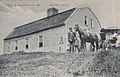
Old Bray House in 1908
-
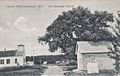
Methodist Church in 1908
-
Steamboat leaving in 1909


Geography
According to the United States Census Bureau, the town has a total area of 51.12 square miles (132.40 km2), of which 31.13 square miles (80.63 km2) is land and 19.99 square miles (51.77 km2) is water. Brooksville is bounded on the west by Penobscot Bay, on the north and east by the Bagaduce River, a tidal estuary, and on the south by Eggemoggin Reach. It is nearly an island, with just two slim land bridges to the rest of the mainland. It has 53.75 miles (86.50 km) of shoreline.
Brooksville is crossed by state routes 175 and 176.
Demographics
| Historical population | |||
|---|---|---|---|
| Census | Pop. | %± | |
| 1820 | 972 | — | |
| 1830 | 1,089 | 12.0% | |
| 1840 | 1,246 | 14.4% | |
| 1850 | 1,333 | 7.0% | |
| 1860 | 1,428 | 7.1% | |
| 1870 | 1,275 | −10.7% | |
| 1880 | 1,419 | 11.3% | |
| 1890 | 1,310 | −7.7% | |
| 1900 | 1,171 | −10.6% | |
| 1910 | 1,176 | 0.4% | |
| 1920 | 1,019 | −13.4% | |
| 1930 | 810 | −20.5% | |
| 1940 | 805 | −0.6% | |
| 1950 | 751 | −6.7% | |
| 1960 | 603 | −19.7% | |
| 1970 | 673 | 11.6% | |
| 1980 | 753 | 11.9% | |
| 1990 | 760 | 0.9% | |
| 2000 | 911 | 19.9% | |
| 2010 | 934 | 2.5% | |
| 2020 | 935 | 0.1% | |
| U.S. Decennial Census | |||
2010 census
As of the census of 2010, there were 934 people, 437 households, and 292 families living in the town. The population density was 30.0 inhabitants per square mile (11.6/km2). There were 934 housing units at an average density of 30.0 per square mile (11.6/km2). The racial makeup of the town was 95.6% White, 0.2% Native American, 1.9% Asian, 0.5% from other races, and 1.7% from two or more races. Hispanic or Latino of any race were 1.1% of the population.
There were 437 households, of which 20.4% had children under the age of 18 living with them, 57.0% were married couples living together, 6.9% had a female householder with no husband present, 3.0% had a male householder with no wife present, and 33.2% were non-families. 26.1% of all households were made up of individuals, and 11.2% had someone living alone who was 65 years of age or older. The average household size was 2.14 and the average family size was 2.52.
The median age in the town was 53 years. 15.3% of residents were under the age of 18; 5.8% were between the ages of 18 and 24; 18% were from 25 to 44; 35.7% were from 45 to 64; and 25.2% were 65 years of age or older. The gender makeup of the town was 48.0% male and 52.0% female.
Points of interest
- The massive gravel pit on Varnumville Road, once the best farmland in the town but now mined for gravel and also used as an illegal dumping site for toxic chemicals. A garbage fire burned there from Christmas of 2001 to May 2002. While the local community has made some efforts to draw government attention to the situation, as of the present date little has been done.
- Holbrook Island Sanctuary State Park, a protected natural area on Penobscot Bay for hiking and wildlife watching.
- The reversing falls on the Bagaduce River at Davis Narrows, where Routes 175 and 176 cross the river.
National historic sites
- Topside, added to the National Register of Historic Places August 13, 1975.
- Von Mach Site, added to the National Register of Historic Places January 17, 1989.
- West Brooksville Congregational Church, added to the National Register of Historic Places June 20, 1995.
Notable people

- Eliot Coleman, farmer, author, agricultural researcher and educator, and proponent of organic farming
- Melissa Coleman, author, columnist, and writer
- Clarence Milville Condon, Medal of Honor recipient during the Philippine–American War
- Daniel Hoffman, poet laureate of the United States, 1973–1974
- Edmund von Mach, German-American art historian
- John Mack, Civil War seaman, Medal of Honor recipient
- Robert McCloskey, award-winning author and illustrator of children's books
- Helen Nearing wife of Scott Nearing, advocates of simple living, and leaders of the back-to-the-land movement
- Scott Nearing, husband of Helen Nearing
- Clara Parkes, author, yarn critic, and wool expert
- Robert Shetterly, painter, Americans Who Tell The Truth
- Peter Suber, a leader in the movement for open access to research
- David Atwood Wasson, early American intellectual leader
See also
 In Spanish: Brooksville (Maine) para niños
