
Nevada facts for kids
Quick facts for kids
Nevada
|
|||
|---|---|---|---|
| State of Nevada | |||
|
|||
| Nickname(s):
The Silver State (official);
The Sagebrush State; The Battle Born State |
|||
| Motto(s):
All for Our Country
|
|||
| Anthem: "Home Means Nevada" |
|||

Map of the United States with Nevada highlighted
|
|||
| Country | United States | ||
| Before statehood | Nevada Territory, Utah Territory, Arizona Territory | ||
| Admitted to the Union | October 31, 1864 (36th) | ||
| Capital | Carson City | ||
| Largest city | Las Vegas | ||
| Largest metro | Las Vegas Valley | ||
| Legislature | Nevada Legislature | ||
| • Upper house | Senate | ||
| • Lower house | Assembly | ||
| Area | |||
| • Total | 110,577 sq mi (286,382 km2) | ||
| • Land | 109,781.18 sq mi (284,332 km2) | ||
| • Water | 791 sq mi (2,048 km2) 0.72% | ||
| Area rank | 7th | ||
| Dimensions | |||
| • Length | 492 mi (787 km) | ||
| • Width | 322 mi (519 km) | ||
| Elevation | 5,500 ft (1,680 m) | ||
| Highest elevation | 13,147 ft (4,007.1 m) | ||
| Lowest elevation
(Colorado River at California border)
|
481 ft (147 m) | ||
| Population
(2020)
|
|||
| • Total | 3,104,614 | ||
| • Rank | 32nd | ||
| • Density | 26.8/sq mi (10.3/km2) | ||
| • Density rank | 42nd | ||
| • Median household income | $60,365 | ||
| • Income rank | 24th | ||
| Demonym(s) | Nevadan | ||
| Language | |||
| • Official language | None | ||
| Time zones | |||
| most of state | UTC−08:00 (Pacific) | ||
| • Summer (DST) | UTC−07:00 (PDT) | ||
| West Wendover | UTC−07:00 (Mountain) | ||
| • Summer (DST) | UTC−06:00 (MDT) | ||
| USPS abbreviation |
NV
|
||
| ISO 3166 code | US-NV | ||
| Trad. abbreviation | Nev. | ||
| Latitude | 35° N to 42° N | ||
| Longitude | 114° 2′ W to 120° W | ||


| Nevada state symbols | |
|---|---|
| Living insignia | |
| Bird | Mountain bluebird (Sialia currucoides) |
| Fish | Lahontan cutthroat trout (Oncorhynchus clarkii henshawi) |
| Flower | Sagebrush (Artemisia tridentata) |
| Grass | Indian Rice Grass |
| Insect | Vivid Dancer Damselfly (Argia vivida) |
| Mammal | Desert bighorn sheep |
| Reptile | Desert tortoise (Gopherus agassizii) |
| Tree | Bristlecone pine, Single-leaf Piñon (Pinus monophylla) |
| Inanimate insignia | |
| Colors | Silver, Blue |
| Fossil | Ichthyosaur (Shonisaurus popularis) |
| Gemstone | Virgin Valley Black Fire Opal |
| Mineral | Silver |
| Rock | Sandstone |
| Soil | Orovada series |
| Song | Home Means Nevada |
| Other | Element: Neon |
| State route marker | |
 |
|
| State quarter | |

Released in 2006
|
|
| Lists of United States state symbols | |
Nevada is a state in the Western region of the United States. It is bordered by Oregon to the northwest, Idaho to the northeast, California to the west, Arizona to the southeast, and Utah to the east. Nevada is the 7th-most extensive, the 32nd-most populous, and the 9th-least densely populated of the U.S. states. Nearly three-quarters of Nevada's people live in Clark County, which contains the Las Vegas–Paradise metropolitan area, including three of the state's four largest incorporated cities. Nevada's capital is Carson City while the largest city is Las Vegas.
Nevada is officially known as the "Silver State" because of the importance of silver to its history and economy. It is also known as the "Battle Born State" because it achieved statehood during the Civil War (the words "Battle Born" also appear on the state flag); as the "Sagebrush State", for the native plant of the same name; and as the "Sage-hen State". The name means "snowy" in Spanish, referring to Nevada's small overlap with the Sierra Nevada mountain range; however, the rest of Nevada is largely desert and semi-arid, much of it within the Great Basin. Areas south of the Great Basin are within the Mojave Desert, while Lake Tahoe and the Sierra Nevada lie on the western edge. About 86% of the state's land is managed by various jurisdictions of the U.S. federal government, both civilian and military.
American Indians of the Paiute, Shoshone, and Washoe tribes inhabited what is now Nevada. The first Europeans to explore the region were Spanish. They called the region Nevada (snowy) because of the snow which covered the mountains in winter similar to the Sierra Nevada in Spain. The area formed part of Alta California's territory within the Viceroyalty of New Spain, which gained independence as Mexico in 1821. The United States annexed the area in 1848 after its victory in the Mexican–American War, and it was incorporated as part of Utah Territory in 1850. The discovery of silver at the Comstock Lode in 1859 led to a population boom that became an impetus to the creation of Nevada Territory out of western Utah Territory in 1861. Nevada became the 36th state on October 31, 1864, as the second of two states added to the Union during the Civil War (the first being West Virginia).
Nevada has a reputation for its libertarian laws. In 1940, with a population of just over 110,000 people, Nevada was by far the least-populated state, with less than half the population of the next least-populous state, Wyoming. However, legalized gambling and lenient marriage and divorce laws transformed Nevada into a major tourist destination in the 20th century. The tourism industry remains Nevada's largest employer, with mining continuing as a substantial sector of the economy: Nevada is the fourth-largest producer of gold in the world. Nevada is the driest state, and over time and influenced by climate change, droughts in Nevada have been increasing in frequency and severity, putting a further strain on Nevada's water security.
Contents
Etymology and pronunciation

The name "Nevada" comes from the Spanish nevada meaning "snow-covered", after the Sierra Nevada ("snow-covered mountain range").
Carson City establishment

The first European Americans to arrive in what is known as Eagle Valley were John C. Frémont and his exploration party in January 1843. Fremont named the river flowing through the valley Carson River in honor of Kit Carson, the mountain man and scout he had hired for his expedition. Prior to the Fremont expedition, the Washoe people inhabited the valley and surrounding areas. Settlers named the area Washoe in reference to the tribe.
By 1851 the Eagle Station ranch located along the Carson River served as a trading post and stopover for travelers on the California Trail's Carson Branch which ran through Eagle Valley. The valley and trading post received their name from a bald eagle that was hunted and killed by one of the early settlers and was featured on a wall inside the post.
As the area was part of the Utah Territory, it was governed from Salt Lake City, where the territorial government was headquartered. Early settlers bristled at the control exerted by Mormon-influenced officials and desired the creation of the Nevada territory. A vigilante group of influential settlers, headed by Abraham Curry, sought a site for a capital city for the envisioned territory. In 1858, Abraham Curry bought Eagle Station and thereafter renamed the settlement Carson City. As Curry and several other partners had Eagle Valley surveyed for development. Curry had decided for himself that Carson City would someday serve as the capital city and left a 10-acre (40,000 m2) plot open in the center of town for a future capitol building.
When Nevada became a state in 1864 during the American Civil War, Carson City was confirmed as Nevada's permanent capital.
Geography


Nevada is almost entirely within the Basin and Range Province, and is broken up by many north-south mountain ranges. Most of these ranges have endorheic valleys between them, which belies the image portrayed by the term Great Basin.
Much of the northern part of the state is within the Great Basin, a mild desert that experiences hot temperatures in the summer and cold temperatures in the winter. Occasionally, moisture from the Arizona Monsoon will cause summer thunderstorms; Pacific storms may blanket the area with snow.
The Humboldt River crosses the state from east to west across the northern part of the state, draining into the Humboldt Sink near Lovelock. Several rivers drain from the Sierra Nevada eastward, including the Walker, Truckee, and Carson rivers. All of these rivers are endorheic basins, ending in Walker Lake, Pyramid Lake, and the Carson Sink, respectively. However, not all of Nevada is within the Great Basin. Tributaries of the Snake River drain the far north, while the Colorado River, which also forms much of the boundary with Arizona, drains much of southern Nevada.
The mountain ranges, some of which have peaks above 13,000 feet (4,000 m), harbor lush forests high above desert plains, creating sky islands for endemic species. The valleys are often no lower in elevation than 3,000 feet (910 m), while some in central Nevada are above 6,000 feet (1,800 m).
The southern third of the state, where the Las Vegas area is situated, is within the Mojave Desert. The area receives less rain in the winter but is closer to the Arizona Monsoon in the summer. The terrain is also lower, mostly below 4,000 feet (1,200 m), creating conditions for hot summer days and cool to chilly winter nights (the result of temperature inversion).
Nevada and California have by far the longest diagonal line (in respect to the cardinal directions) as a state boundary at just over 400 miles (640 km). This line begins in Lake Tahoe nearly 4 miles (6.4 km) offshore (in the direction of the boundary), and continues to the Colorado River where the Nevada, California, and Arizona boundaries merge 12 miles (19 km) southwest of the Laughlin Bridge.
The largest mountain range in the southern portion of the state is the Spring Mountain Range, just west of Las Vegas. The state's lowest point is along the Colorado River, south of Laughlin.
Nevada has 172 mountain summits with 2,000 feet (610 m) of prominence. Nevada ranks second in the USA, behind Alaska, and ahead of California, Montana, and Washington. Nevada is the most mountainous state in the contiguous United States.
Climate
Nevada is the driest state in the United States. It is made up of mostly desert and semi-arid climate regions, and, with the exception of the Las Vegas Valley, the average summer diurnal temperature range approaches 40 °F (22 °C) in much of the state.
While winters in northern Nevada are long and fairly cold, the winter season in the southern part of the state tends to be of short duration and mild. Most parts of Nevada receive scarce precipitation during the year. Most rain that falls in the state falls on the lee side (east and northeast slopes) of the Sierra Nevada.
Vegetation
The vegetation of Nevada is diverse and differs by state area. Nevada contains six biotic zones: alpine, sub-alpine, ponderosa pine, pinion-juniper, sagebrush and creosotebush.
Counties


Nevada is divided into political jurisdictions designated as counties. Carson City is officially a consolidated municipality; however, for many purposes under state law it is considered to be a county. As of 1919 there were 17 counties in the state, ranging from 146 to 18,159 square miles (380 to 47,030 km2).
Lake County, one of the original nine counties formed in 1861, was renamed Roop County in 1862. Part of the county became Lassen County, California in 1864. The portion that remained in Nevada was annexed in 1883 by Washoe County.
In 1969, Ormsby County was dissolved and the Consolidated Municipality of Carson City was created by the Legislature in its place co-terminous with the old boundaries of Ormsby County.
Bullfrog County was formed in 1987 from part of Nye County. After the creation was declared unconstitutional the county was abolished in 1989.
Humboldt county was designated as a county in 1856 by Utah Territorial Legislature and again in 1861 by the new Nevada Legislature.
Clark County is the most populous county in Nevada, accounting for nearly three-quarters of its residents. Las Vegas, Nevada's most populous city, has been the county seat since the county was created in 1909 from a portion of Lincoln County, Nevada. Prior to that it was a part of Arizona Territory. Clark County attracts numerous tourists. An estimated 44 million people visited Clark County in 2014.
Washoe County is the second most populous county of Nevada. Its county seat is Reno. Washoe County includes the Reno–Sparks metropolitan area.
Lyon County is the third most populous county. It was one of the nine original counties created in 1861. It was named after Nathaniel Lyon, the first Union General to be killed in the Civil War. Its current county seat is Yerington. Its first county seat was established at Dayton on November 29, 1861.
| County name | County seat | Year founded | 2010 population | Percent of total | Area (mi2) | Percent of total | Population density (/mi2) |
|---|---|---|---|---|---|---|---|
| Carson City | Carson City | 1861 | 55,274 | 2.63 % | 146 | 0.13 % | 378.59 |
| Churchill | Fallon | 1861 | 24,877 | 0.92 % | 5,023 | 4.54 % | 4.95 |
| Clark | Las Vegas | 1908 | 1,951,269 | 72.25 % | 8,091 | 7.32 % | 241.17 |
| Douglas | Minden | 1861 | 46,997 | 1.74 % | 738 | 0.67 % | 63.68 |
| Elko | Elko | 1869 | 48,818 | 1.81 % | 17,203 | 15.56 % | 2.84 |
| Esmeralda | Goldfield | 1861 | 783 | 0.03 % | 3,589 | 3.25 % | 0.22 |
| Eureka | Eureka | 1869 | 1,987 | 0.07 % | 4,180 | 3.78 % | 0.48 |
| Humboldt | Winnemucca | 1856/1861 | 16,528 | 0.61 % | 9,658 | 8.74 % | 1.71 |
| Lander | Battle Mountain | 1861 | 5,775 | 0.21 % | 5,519 | 4.99 % | 1.05 |
| Lincoln | Pioche | 1866 | 5,345 | 0.20 % | 10,637 | 9.62 % | 0.50 |
| Lyon | Yerington | 1861 | 51,980 | 1.92 % | 2,016 | 1.82 % | 25.78 |
| Mineral | Hawthorne | 1911 | 4,772 | 0.18 % | 3,813 | 3.45 % | 1.25 |
| Nye | Tonopah | 1864 | 43,946 | 1.63 % | 18,159 | 16.43 % | 2.42 |
| Pershing | Lovelock | 1919 | 6,753 | 0.25 % | 6,068 | 5.49 % | 1.11 |
| Storey | Virginia City | 1861 | 4,010 | 0.15 % | 264 | 0.24 % | 15.19 |
| Washoe | Reno | 1861 | 421,407 | 15.60 % | 6,551 | 5.93 % | 64.32 |
| White Pine | Ely | 1869 | 10,030 | 0.37 % | 8,897 | 8.05 % | 1.12 |
| Totals | Counties: 17 | 2,700,551 | 110,552 | 24.43 |
History
Before 1861
.png)
Francisco Garcés was the first European in the area, Nevada was annexed as a part of the Spanish Empire in the northwestern territory of New Spain.
Administratively, the area of Nevada was part of the Commandancy General of the Provincias Internas in the Viceroyalty of New Spain. Nevada became a part of Alta California (Upper California) province in 1804 when the Californias were split.
With the Mexican War of Independence won in 1821, the province of Alta California became a territory (state) of Mexico, with small population.
Jedediah Smith entered the Las Vegas Valley in 1827, and Peter Skene Ogden traveled the Humboldt River in 1828. When the Mormons created the State of Deseret in 1847, they laid claim to all of Nevada within the Great Basin and the Colorado watershed. In June 1855, William Bringhurst and 29 fellow Mormon missionaries from Utah arrived at this site just northeast of downtown Las Vegas and built a 150-foot square adobe fort, the first permanent structure erected in the valley, which remained under the control of Salt Lake City until the winter of 1858-1859.
As a result of the Mexican–American War and the Treaty of Guadalupe-Hidalgo, Mexico permanently lost Alta California in 1848. The new areas acquired by the United States continued to be administered as territories.
As part of the Mexican Cession (1848) and the subsequent California Gold Rush that used Emigrant Trails through the area, the state's area evolved first as part of the Utah Territory, then the Nevada Territory (March 2, 1861; named for the Sierra Nevada).

See History of Utah, History of Las Vegas, and the discovery of the first major U.S. deposit of silver ore in Comstock Lode under Virginia City, Nevada in 1859.
Separation from Utah Territory

On March 2, 1861, the Nevada Territory separated from the Utah Territory and adopted its current name, shortened from Sierra Nevada (Spanish for "snow-covered mountain range").
The 1861 southern boundary is commemorated by Nevada Historical Markers 57 and 58 in Lincoln and Nye counties.
Statehood (1864)
Eight days before the presidential election of 1864, Nevada became the 36th state in the union. Statehood was rushed to the date of October 31 to help ensure Abraham Lincoln's reelection on November 8 and post-Civil War Republican dominance in Congress, as Nevada's mining-based economy tied it to the more industrialized Union. As it turned out, however, Lincoln and the Republicans won the election handily, and did not need Nevada's help.
Nevada is one of only two states to significantly expand its borders after admission to the Union. (The other is Missouri, which acquired additional territory in 1837 due to the Platte Purchase.)
In 1866 another part of the western Utah Territory was added to Nevada in the eastern part of the state, setting the current eastern boundary.
Nevada achieved its current southern boundaries on January 18, 1867, when it absorbed the portion of Pah-Ute County in the Arizona Territory west of the Colorado River, essentially all of present-day Nevada south of the 37th parallel. The transfer was prompted by the discovery of gold in the area, and it was thought by officials that Nevada would be better able to oversee the expected population boom. This area includes most of what is now Clark County and the Las Vegas metropolitan area.
Mining shaped Nevada's economy for many years. When Mark Twain lived in Nevada during the period described in Roughing It, mining had led to an industry of speculation and immense wealth. However, both mining and population declined in the late 19th century. However, the rich silver strike at Tonopah in 1900, followed by strikes in Goldfield and Rhyolite, again put Nevada's population on an upward trend.
Gambling and labor

Unregulated gambling was commonplace in the early Nevada mining towns but was outlawed in 1909 as part of a nationwide anti-gambling crusade. Because of subsequent declines in mining output and the decline of the agricultural sector during the Great Depression, Nevada again legalized gambling on March 19, 1931, with approval from the legislature. Governor Fred B. Balzar's signature enacted the most liberal divorce laws in the country and open gambling. The reforms came just eight days after the federal government presented the $49 million construction contract for Boulder Dam (now Hoover Dam).
Nuclear testing
The Nevada Test Site, 65 miles (105 km) northwest of the city of Las Vegas, was founded on January 11, 1951, for the testing of nuclear weapons. The site consists of about 1,350 square miles (3,500 km2) of desert and mountainous terrain. Nuclear testing at the Nevada Test Site began with a 1 kiloton of TNT (4.2 TJ) bomb dropped on Frenchman Flat on January 27, 1951. The last atmospheric test was conducted on July 17, 1962, and the underground testing of weapons continued until September 23, 1992. The location is known for having the highest concentration of nuclear-detonated weapons in the U.S.
Over 80% of the state's area is owned by the federal government. The primary reason for this is that homesteads were not permitted in large enough sizes to be viable in the arid conditions that prevail throughout desert Nevada. Instead, early settlers would homestead land surrounding a water source, and then graze livestock on the adjacent public land, which is useless for agriculture without access to water (this pattern of ranching still prevails).
Demographics
Population

| Historical population | |||
|---|---|---|---|
| Census | Pop. | %± | |
| 1860 | 6,857 | — | |
| 1870 | 42,941 | 526.2% | |
| 1880 | 62,266 | 45.0% | |
| 1890 | 47,355 | −23.9% | |
| 1900 | 42,335 | −10.6% | |
| 1910 | 81,875 | 93.4% | |
| 1920 | 77,407 | −5.5% | |
| 1930 | 91,058 | 17.6% | |
| 1940 | 110,247 | 21.1% | |
| 1950 | 160,083 | 45.2% | |
| 1960 | 285,278 | 78.2% | |
| 1970 | 488,738 | 71.3% | |
| 1980 | 800,493 | 63.8% | |
| 1990 | 1,201,833 | 50.1% | |
| 2000 | 1,998,257 | 66.3% | |
| 2010 | 2,700,551 | 35.1% | |
| 2020 | 3,104,614 | 15.0% | |
| Source: 1910–2020 | |||
The United States Census Bureau determined Nevada had a population of 3,104,614 at the 2020 U.S. census. In 2021, the estimated population of Nevada was 3,143,991, an increase of 39,377 residents (1.27%) since the 2020 census. Nevada had the highest percentage growth in population from 2017 to 2018. At the 2020 census, 6.0% of the state's population were reported as under 5, 22.5% were under 18, and 16.1% were 65 or older. Females made up about 49.8% of the population.
Since the 2020 census, the population of Nevada had a natural increase of 2,374 (the net difference between 42,076 births and 39,702 deaths); and an increase due to net migration of 36,605 (of which 34,280 was due to domestic and 2,325 was due to international migration).
The center of population of Nevada is in southern Nye County. In this county, the unincorporated town of Pahrump, 60 miles (97 km) west of Las Vegas on the California state line, has grown very rapidly from 1980 to 2020. At the 2020 census, the town had 44,738 residents. Las Vegas grew from a gulch of 100 people in 1900 to 10,000 by 1950 to 100,000 by 1970, and was America's fastest-growing city and metropolitan area from 1960 to 2000.
From about the 1940s until 2003, Nevada was the fastest-growing state in the U.S. percentage-wise. Between 1990 and 2000, Nevada's population increased by 66%, while the nation's population increased by 13%. More than two-thirds of the population live in Clark County, which is coextensive with the Las Vegas metropolitan area. Thus, in terms of population, Nevada is one of the most centralized states in the nation.
Henderson and North Las Vegas are among the top 20 fastest-growing U.S. cities with populations over 100,000. The rural community of Mesquite 65 miles (105 km) northeast of Las Vegas was an example of micropolitan growth in the 1990s and 2000s. Other desert towns like Indian Springs and Searchlight on the outskirts of Las Vegas have seen some growth as well.
Since 1950, the rate of population born in Nevada has never peaked above 27 percent, the lowest rate of all states. In 2012, only 25% of Nevadans were born in Nevada.
| Race and Ethnicity | Alone | Total | ||
|---|---|---|---|---|
| White (non-Hispanic) | 45.9% |
|
50.6% |
|
| Hispanic or Latino | — | 28.7% |
|
|
| Multiracial | — | 14.0% |
|
|
| African American (non-Hispanic) | 9.4% |
|
11.1% |
|
| Asian | 8.6% |
|
10.7% |
|
| Native American | 0.8% |
|
2.1% |
|
| Pacific Islander | 0.7% |
|
1.5% |
|
| Other | 0.6% |
|
1.4% |
|
According to the 2017 American Community Survey, 28.2% of Nevada's population were of Hispanic or Latino origin (of any race): Mexican (21.4%), Puerto Rican (0.9%), Cuban (1.0%), and other Hispanic or Latino origin (4.8%). The five largest non-Hispanic White ancestry groups were: German (11.3%), Irish (9.0%), English (6.9%), Italian (5.8%), and American (4.7%).
In 1980, non-Hispanic whites made up 83.3% of the state's population.
| Racial composition | 1970 | 1990 | 2000 | 2010 |
|---|---|---|---|---|
| White | 86.7% | 78.7% | 65.2% | 66.2% |
| Black | 5.7% | 6.6% | 6.8% | 8.1% |
| Asian | 0.7% | 3.2% | 4.5% | 7.2% |
| Native | 1.6% | 1.6% | 1.3% | 1.2% |
| Other race | 0.3% | 4.4% | 8.0% | 12.0% |
| Two or more races | – | – | 3.8% | 4.7% |
| Hispanic or Latino (of any race) | 5.6% | 10.4% | 19.7% | 26.5% |
As of 2011, 63.6% of Nevada's population younger than age 1 were minorities. Las Vegas is a majority-minority city. According to the United States Census Bureau estimates, as of July 1, 2018, non-Hispanic Whites made up 48.7% of Nevada's population.
In Douglas, Mineral, and Pershing counties, a plurality of residents are of Mexican ancestry. In Nye County and Humboldt County, residents are mostly of German ancestry; Washoe County has many Irish Americans. Americans of English descent form pluralities in Lincoln County, Churchill County, Lyon County, White Pine County, and Eureka County.
Asian Americans lived in the state since the California Gold Rush of the 1850s brought thousands of Chinese miners to Washoe county. They were followed by a few hundred Japanese farmworkers in the late 19th century. By the late 20th century, many immigrants from China, Japan, Korea, the Philippines, Bangladesh, India, and Vietnam came to the Las Vegas metropolitan area. The city now has one of America's most prolific Asian American communities, with a mostly Chinese and Taiwanese area known as "Chinatown" west of I-15 on Spring Mountain Road. Filipino Americans form the largest Asian American group in the state, with a population of more than 113,000. They comprise 56.5% of the Asian American population in Nevada and constitute about 4.3% of the entire state's population.
Mining booms drew many Greek and Eastern European immigrants to Nevada. In the early twentieth century, Greeks, Slavs, Danes, Japanese, Italians, and Basques poured into Nevada.
Native American tribes in Nevada are the Northern and Southern Paiute, Western Shoshone, Goshute, Hualapai, Washoe, and Ute tribes.
The top countries of origin for immigrants in Nevada were Mexico (39.5 percent of immigrants), the Philippines (14.3 percent), El Salvador (5.2 percent), China (3.1 percent), and Cuba (3 percent).
- Birth data
Note: Births within the table do not add up, due to Hispanics being counted both by their ethnicity and by their race, giving a higher overall number.
| Race | 2013 | 2014 | 2015 | 2016 | 2017 | 2018 | 2019 | 2020 |
|---|---|---|---|---|---|---|---|---|
| White | 27,293 (77.9%) | 27,638 (77.1%) | 27,648 (76.2%) | ... | ... | ... | ... | ... |
| non-Hispanic White | 14,951 (42.7%) | 15,151 (42.2%) | 14,937 (41.2%) | 13,918 (38.4%) | 13,171 (36.8%) | 13,021 (36.5%) | 12,479 (35.6%) | 11,602 (34.5%) |
| Black | 4,215 (12.0%) | 4,603 (12.8%) | 4,803 (13.2%) | 4,205 (11.6%) | 4,471 (12.5%) | 4,564 (12.8%) | 4,514 (12.9%) | 4,533 (13.5%) |
| Asian | 3,097 (8.8%) | 3,145 (8.8%) | 3,337 (9.2%) | 2,666 (7.3%) | 2,685 (7.5%) | 2,613 (7.3%) | 2,587 (7.4%) | 2,467 (7.3%) |
| Pacific Islander | ... | ... | ... | 308 (0.8%) | 322 (0.9%) | 340 (1.0%) | 372 (1.1%) | 358 (1.1%) |
| American Indian | 425 (1.2%) | 475 (1.3%) | 510 (1.4%) | 303 (0.8%) | 305 (0.9%) | 280 (0.8%) | 277 (0.8%) | 234 (0.7%) |
| Hispanic (of any race) | 12,718 (36.3%) | 13,006 (36.3%) | 13,225 (36.4%) | 13,391 (36.9%) | 13,176 (36.8%) | 13,307 (37.3%) | 13,238 (37.7%) | 12,763 (37.9%) |
| Total Nevada | 35,030 (100%) | 35,861 (100%) | 36,298 (100%) | 36,260 (100%) | 35,756 (100%) | 35,682 (100%) | 35,072 (100%) | 33,653 (%) |
- Since 2016, data for births of White Hispanic origin are not collected, but included in one Hispanic group; persons of Hispanic origin may be of any race.

.jpg)

A small percentage of Nevada's population lives in rural areas. The culture of these places differs significantly from major metropolitan areas. People in these rural counties tend to be native Nevada residents, unlike in the Las Vegas and Reno areas, where the vast majority of the population was born in another state. The rural population is also less diverse in terms of race and ethnicity. Mining plays an important role in the economies of the rural counties, with tourism being less prominent. Ranching also has a long tradition in rural Nevada.
Locations by per capita income
| Rank | Place | Per capita income | County | |
|---|---|---|---|---|
| 1 | Incline Village–Crystal Bay | $52,521 | Washoe | |
| 2 | Kingsbury | $41,421 | Douglas | |
| 3 | Mount Charleston | $38,821 | Clark | |
| 4 | Verdi–Mogul | $38,233 | Washoe | |
| 5 | Zephyr Cove–Round Hill Village | $37,218 | Douglas | |
| 6 | Summerlin South | $33,017 | Clark | |
| 7 | Blue Diamond | $30,479 | Clark | |
| 8 | Minden | $30,405 | Douglas | |
| 9 | Boulder City | $29,770 | Clark | |
| 10 | Spanish Springs | $26,908 | Washoe | |
|
For more details, see Nevada locations by per capita income
|
||||
Religion
| Religion in Nevada | ||||
|---|---|---|---|---|
| Religion | Percent | |||
| Protestant | 35% | |||
| Unaffiliated | 28% | |||
| Catholic | 25% | |||
| Mormon | 4% | |||
| Jewish | 2% | |||
| Buddhist | 0.5% | |||
| Hindu | 0.1% | |||
| Muslim | 0.1% | |||
Church attendance in Nevada is among the lowest of all U.S. states. In a 2009 Gallup poll only 30% of Nevadans said they attended church weekly or almost weekly, compared to 42% of all Americans (only four states were found to have a lower attendance rate than Nevada's).
Major religious affiliations of the people of Nevada are: Protestant 35%, Irreligious 28%, Roman Catholic 25%, Latter-day Saints 4%, Jewish 2%, Hindu less than 1%, Buddhist 0.5% and Muslim less than 0.1%. Parts of Nevada (in the eastern parts of the state) are situated in the Mormon Corridor.
The largest denominations by number of adherents in 2010 were the Roman Catholic Church with 451,070; The Church of Jesus Christ of Latter-day Saints with 175,149; and the Southern Baptist Convention with 45,535; Buddhist congregations 14,727; Baháʼí Faith 1,723; and Muslim 1,700. The Jewish community is represented by The Rohr Jewish Learning Institute and Chabad. According to the Church of Jesus Christ of Latter-day Saints, 6.2% of Nevadans are adherents, making it the sixth highest percentage stage in the Union.
Economy


_at_the_Bruneau_River,_about_38.6_miles_north_of_Deeth_in_Elko_County,_Nevada.jpg)

The economy of Nevada is tied to tourism (especially entertainment and gambling related), mining, and cattle ranching. Nevada's industrial outputs are tourism, entertainment, mining, machinery, printing and publishing, food processing, and electric equipment. The Bureau of Economic Analysis estimates Nevada's total state product in 2018 was $170 billion. The state's per capita personal income in 2020 was $53,635, ranking 31st in the nation. Nevada's state debt in 2012 was calculated to be $7.5 billion, or $3,100 per taxpayer. As of May 2021, the state's unemployment rate was 7.8%.
Mining
In portions of the state outside of the Las Vegas and Reno metropolitan areas mining plays a major economic role. By value, gold is by far the most important mineral mined. In 2004, 6,800,000 ounces (190,000,000 g) of gold worth $2.84 billion were mined in Nevada, and the state accounted for 8.7% of world gold production. Silver is a distant second, with 10,300,000 ounces (290,000,000 g) worth $69 million mined in 2004. Other minerals mined in Nevada include construction aggregates, copper, gypsum, diatomite and lithium. Despite its rich deposits, the cost of mining in Nevada is generally high, and output is very sensitive to world commodity prices.
Cattle ranching
Cattle ranching is a major economic activity in rural Nevada. Nevada's agricultural outputs are cattle, hay, alfalfa, dairy products, onions, and potatoes. As of January 1, 2006, there were an estimated 500,000 head of cattle and 70,000 head of sheep in Nevada. Most of these animals forage on rangeland in the summer, with supplemental feed in the winter. Calves are generally shipped to out-of-state feedlots in the fall to be fattened for the market. Over 90% of Nevada's 484,000 acres (196,000 ha) of cropland is used to grow hay, mostly alfalfa, for livestock feed. This livestock is usually used for food.
Largest employers
The largest employers in the state, as of the first fiscal quarter of 2011, are the following, according to the Nevada Department of Employment, Training and Rehabilitation:
| Rank | Employer |
|---|---|
| 1 | Clark County School District |
| 2 | Washoe County School District |
| 3 | Clark County |
| 4 | Wynn Las Vegas |
| 5 | Bellagio LLC |
| 6 | MGM Grand Hotel/Casino |
| 7 | Aria Resort & Casino LLC |
| 8 | Mandalay Bay Resort and Casino |
| 9 | Las Vegas Metropolitan Police Department |
| 10 | Caesars Palace |
| 11 | University of Nevada, Las Vegas |
| 12 | The Venetian Casino Resort |
| 13 | The Cosmopolitan of Las Vegas |
| 14 | The Mirage Casino-Hotel |
| 15 | University of Nevada, Reno |
| 16 | University Medical Center of Southern Nevada |
| 17 | The Palazzo Casino Resort |
| 18 | Flamingo Las Vegas Operating Company LLC |
| 19 | Encore Las Vegas |
| 20 | Luxor Las Vegas |
Infrastructure
Transportation


Amtrak's California Zephyr train uses the Union Pacific's original transcontinental railroad line in daily service from Chicago to Emeryville, California, serving Elko, Winnemucca, and Reno. Las Vegas has had no passenger train service since Amtrak's Desert Wind was discontinued in 1997. Amtrak Thruway Motorcoaches provide connecting service from Las Vegas to trains at Needles, California, Los Angeles, and Bakersfield, California; and from Stateline, Nevada, to Sacramento, California. There have been a number of proposals to re-introduce service to either Los Angeles or Southern California.
The Union Pacific Railroad has some railroads in the north and south of Nevada. Greyhound Lines provide some bus service to the state.
Interstate 15 (I-15) passes through the southern tip of the state, serving Las Vegas and other communities. I-215 and I-515 also serve the Las Vegas metropolitan area. I-80 crosses through the northern part of Nevada, roughly following the path of the Humboldt River from Utah in the east and the Truckee River westward through Reno into California. It has a spur route, I-580. Nevada also is served by several U.S. highways: US 6, US 50, US 93, US 95 and US 395. There are also 189 Nevada state routes. Many of Nevada's counties have a system of county routes as well, though many are not signed or paved in rural areas. Nevada is one of a few states in the U.S. that do not have a continuous interstate highway linking its two major population centers – the road connection between the Las Vegas and Reno areas is a combination of several different Interstate and U.S. highways. The Interstate 11 proposed routing may eventually remedy this.
The state is one of just a few in the country to allow semi-trailer trucks with three trailers – what might be called a "road train" in Australia. But American versions are usually smaller, in part because they must ascend and descend some fairly steep mountain passes.
RTC Transit is the public transit system in the Las Vegas metropolitan area. The agency is the largest transit agency in the state and operates a network of bus service across the Las Vegas Valley, including the use of The Deuce, double-decker buses, on the Las Vegas Strip and several outlying routes. RTC RIDE operates a system of local transit bus service throughout the Reno-Sparks metropolitan area. Other transit systems in the state include Carson City's JAC. Most other counties in the state do not have public transportation at all.
Additionally, a 4-mile (6.4 km) monorail system provides public transportation in the Las Vegas area. The Las Vegas Monorail line services several casino properties and the Las Vegas Convention Center on the east side of the Las Vegas Strip, running near Paradise Road, with a possible future extension to Harry Reid International Airport. Several hotels also run their own monorail lines between each other, which are typically several blocks in length.
Harry Reid International Airport in Las Vegas is the busiest airport serving Nevada. The Reno-Tahoe International Airport (formerly known as the Reno Cannon International Airport) is the other major airport in the state.
Energy
Nevada has had a thriving solar energy sector. An independent study in 2013 concluded that solar users created a $36 million net benefit. However, in December 2015, the Public Utility Commission let the state's only power company, NV Energy, charge higher rates and fees to solar panel users, leading to an immediate collapse of rooftop solar panel use.
In December 1987, Congress amended the Nuclear Waste Policy Act to designate Yucca Mountain nuclear waste repository as the only site to be characterized as a permanent repository for all of the nation's highly radioactive waste.
Affordable housing
Over the last six years, the National Low Income Housing Coalition calculates the discrepancy between available affordable housing units and renters who earn below the poverty line. In Nevada, only 15 affordable rental homes are available per 100 extremely low income (ELI) households. The shortage extends to a deficit in supply of 71,358 affordable rental homes. This is the largest discrepancy of any state. The most notable catalyst for this shortage is The Great Recession and Housing Crisis of 2007 and 2008. Since then, housing prices have increased while demand has increased, and supply has struggled to match the increase in demand. In addition to this, low-income service workers are slowly being pushed out by an influx of tech professionals. In Nevada there is essentially a standard of six-figure income to affordably rent a single-family home. Considering the average salary in Nevada, $54,842 per year, this standard is on average, unaffordable. The disproportionate cost of housing compared to average salary has led to 112,872 renters to be paying more than half of their yearly income towards housing.
The definition of an affordable home is “one that a household can obtain for 30 percent or less of its annual income”. So, there is clearly a long way to go in order to close the gap between housing prices and relative income in the state. Renters are looking for solutions to still be able to live in the state in a way that their income can support. As a result, single adults are being forced to split rent with other renters or move residences to farther outside metro areas. One solution being offered is to increase the supply of higher income positions within the state to make things more affordable. However, this would require Nevadans to retrain in new jobs or careers.
Parks and recreation areas


.jpg)

Recreation areas maintained by the federal government
Northern Nevada
- California National Historic Trail
- Humboldt National Forest
- Great Basin National Park
- Old Spanish National Historic Trail
- Pony Express National Historic Trail
Southern Nevada
- Ash Meadows National Wildlife Preserve
- Bootleg Canyon Mountain Bike Park
- Toiyabe National Forest
- Inyo National Forest
- Mount Charleston and the Mount Charleston Wilderness
- Spring Mountains and the Spring Mountains National Recreation Area
- Lake Mead National Recreation Area
- Death Valley National Park
Wilderness
There are 68 designated wilderness areas in Nevada, protecting some 6,579,014 acres (2,662,433 ha) under the jurisdiction of the National Park Service, U.S. Forest Service, and Bureau of Land Management.
State parks
The Nevada state parks comprise protected areas managed by the state of Nevada, including state parks, state historic sites, and state recreation areas. There are currently 24 state park units, including Van Sickle Bi-State Park which opened in July 2011 and is operated in partnership with the state of California.
Military
Several United States Navy ships have been named USS Nevada in honor of the state. They include:
- USS Nevada (1865)
- USS Nevada (BM-8)
- USS Nevada (BB-36)
- USS Nevada (SSBN-733)
Area 51 is located near Groom Lake, a dry salt lake bed.
The military bases host a number of activities including the Joint Unmanned Aerial Systems Center of Excellence, the Naval Strike and Air Warfare Center, Nevada Test and Training Range, Red Flag, the U.S. Air Force Thunderbirds, the United States Air Force Warfare Center, the United States Air Force Weapons School, and the United States Navy Fighter Weapons School.
Songs about Nevada
- "Silver State Fanfare" – the official state march by Gerald G. Willis. Codified by the Nevada Legislature in 2001 at NRS 235.035
- "Nevada State March" by J.P. Meder (1848-1908), 1894
- "Sin City" by AC/DC
- "Sands of Nevada" from Mark Knopfler's 2000 release Sailing to Philadelphia
- "Sin City" from Limbeck's 2005 release Let Me Come Home
- "Home Means Nevada", the state song of Nevada, by Bertha Rafetto
- "Nevada" by Riders in the Sky from the album Best of the West
- "Night Time In Nevada" by Dulmage/Clint/Pascoe, 1931
- "Nevada's Grace" by Atreyu, twelfth track off 2004's The Curse
- "Battle Born" by The Killers, last track on the 2012 album also named Battle Born
- "Winner's Casino" by Richmond Fontaine off the 2002 album Winnemucca
- "Reno" by Doug Supernaw off the album Red and Rio Grande released in 1993.
- "Ooh Las Vegas" by Gram Parsons off the album Return of the Grievous Angel.
- "Darcy Farrow" by Jimmie Dale Gilmore off the album One Endless Night.
- "Viva Las Vegas" recorded by Elvis Presley (1963)
- "Goldfield" by Rocky Votolato off of the album Makers (2006)
- "Vegas Lights" from Panic! at the Disco
- Album Too Weird To Live, Too Rare To Die (released 2013)
State symbols

- State animal: desert bighorn sheep
- State artifact: Tule duck decoy
- State bird: mountain bluebird
- State colors: silver and blue
- State fish: Lahontan cutthroat trout
- State flower: sagebrush (Artemisia tridentata)
- State fossil: ichthyosaur
- State grass: Indian ricegrass
- State march: "Silver State Fanfare" by Gerald G. Willis
- State metal: silver (Ag)
- State mottos: "Battle Born" and "All For Our Country"
- State precious gemstone: Virgin Valley black fire opal
- State semiprecious gemstone: Nevada turquoise
- State slogan: "The Battle Born State"
- State song: "Home Means Nevada" by Bertha Raffetto
- State reptile: desert tortoise
- State rock: sandstone
- State soil: Orovada series
- State tartan: A particular tartan designed for Nevada by Richard Zygmunt Pawlowski
- State trees: single-leaf pinyon pine (Pinus monophylla) and bristlecone pine (Pinus longaeva)
Education
Education in Nevada is achieved through public and private elementary, middle, and high schools, as well as colleges and universities.
A May 2015 educational reform law expanded school choice options to 450,000 Nevada students who are at up to 185% of the federal poverty level. Education savings accounts (ESAs) are enabled by the new law to help pay the tuition for private schools. Alternatively, families "can use funds in these accounts to also pay for textbooks and tutoring".
Approximately 86.9% of Nevada residents have attained at least a high school degree or equivalent, which is below the national average of 88.6%.
Public school districts
Public school districts in Nevada include:
- Carson City School District
- Churchill County School District
- Clark County School District, the fifth largest school district in the United States
- Douglas County School District
- Elko County School District
- Esmeralda County School District
- Eureka County School District
- Humboldt County School District
- Lander County School District
- Lincoln County School District
- Lyon County School District
- Mineral County School District
- Nye County School District
- Pershing County School District
- Storey County School District
- Washoe County School District
- White Pine County School District
Colleges and universities
- Nevada System of Higher Education
- University of Nevada, Las Vegas (UNLV)
- University of Nevada, Reno (UNR)
- Nevada State College (NSC)
- Truckee Meadows Community College (TMCC)
- Great Basin College
- College of Southern Nevada (CSN)
- Western Nevada College (WNC)
- Sierra Nevada College
- Touro University Nevada
- Roseman University of Health Sciences
Research institutes
- Desert Research Institute
The Nevada Aerospace Hall of Fame provides educational resources and promotes the aerospace and aviation history of the state.
Images for kids
-
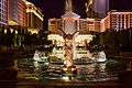
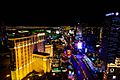
Las Vegas Strip, 2010s
-
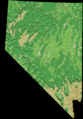
Topographic map of Nevada
-
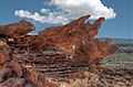
Little Finland rock formation in Nevada
-
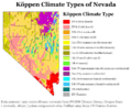
Köppen climate types of Nevada, using 1991-2020 climate normals.
-
The Las Vegas Strip looking South
-
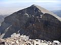
The quartzite of Doso Doyabi in Great Basin National Park
-
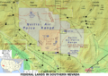
A map that details the federal land in southern Nevada, showing Nellis Air Force Base Complex and Nevada Test Site
.jpg)
.jpg)


.jpg)


See also
 In Spanish: Nevada para niños
