
Amsterdam facts for kids
Quick facts for kids
Amsterdam
|
|||
|---|---|---|---|
|
City and municipality
|
|||
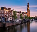
    Images, from top down, left to right: Grachtengordel, one of Amsterdam's canals, Royal Concertgebouw, Rijksmuseum
|
|||
|
|||
| Nickname(s):
Mokum, Damsko
|
|||
| Motto(s):
Heldhaftig, Vastberaden, Barmhartig (Valiant, Steadfast, Compassionate)
|
|||

Location in North Holland
|
|||
| Country | Netherlands | ||
| Province | |||
| Boroughs |
Eight districts
Centrum
Noord West Nieuw-West Zuid Oost Zuidoost Westpoort |
||
| Government | |||
| • Body | Municipal council | ||
| Area | |||
| • Municipality | 84.68 sq mi (219.32 km2) | ||
| • Land | 64.00 sq mi (165.76 km2) | ||
| • Water | 20.68 sq mi (53.56 km2) | ||
| • Randstad | 1,175 sq mi (3,043 km2) | ||
| Elevation | −6.6 ft (−2 m) | ||
| Population
(municipality & urban, Feb 2017 (CBS); metro 2014 (OIS Amsterdam); Randstad, 2011)
|
|||
| • Municipality | 851,573 | ||
| • Density | 12,710/sq mi (4,908/km2) | ||
| • Urban | 1,351,587 | ||
| • Metro region | 2,431,000 | ||
| • Randstad | 7,100,000 | ||
| Demonym(s) | Amsterdammer, A'dammer | ||
| Time zone | UTC+1 (CET) | ||
| • Summer (DST) | UTC+2 (CEST) | ||
| Postcode |
1000–1109
|
||
| Area code | 020 | ||
| GeoTLD | .amsterdam | ||


Amsterdam is the capital and largest city in the European country of the Netherlands. It is famous for its canals and dikes. Unlike most other countries, the national government does not meet in Amsterdam, but in The Hague.
As of 2016, about 838,000 people were living in Amsterdam. There are two universities (the University of Amsterdam and the Free University Amsterdam) and an international airport (Schiphol Airport) there. About 2.2 million people live in the metropolitan area. The city of Amsterdam is the world's most multicultural city. People from 175 different countries live there.
Contents
History
A dam was built in 13th century on the river Amstel (that is why the city is called Amsterdam). The old harbor of the city, Damrak, is now one of the busiest streets in the city. In 1275, Floris V, count of Holland and Zeeland, gave the people of Amsterdam more freedom. Amsterdam became a major trading port, with a successful trading route to the Baltic Sea. The city grew quickly during the 15th century. Because Amsterdam lies in swamp area, the builders of the city had to dig canals and use the ground they dug to make the land higher. Homes were built on wooden poles, and the canals served as a sewer.
The city was one of the first cities in Western Europe to be somewhat democratic: wealthy citizens chose the leaders of the city. Amsterdam declared war on the Spanish in 1578, during the Eighty Years' War. When the city of Antwerp fell to the Spanish in 1585, many people of Antwerp fled to Amsterdam. Antwerp was also a major trading city, and when its people moved to Amsterdam, they took their trading networks with them. This made Amsterdam an even more important trading city. During what is called the "Dutch Golden Age," the number of people living in Amsterdam rose from less than 30,000 in 1570 to over 100,000 in 1622. That number would even rise to 200,000 near the end of the 17th century, making the city a very large city for its time (only London and Paris also had that many people). In the 18th century, the number of people living in Amsterdam fell back to 140,000, ending the Golden Age.
The first trains and trams in Amsterdam were built during the 19th century. The first train ran from Amsterdam to Haarlem in 1839. The number of people was rising, with about 250,000 living in Amsterdam in 1850 and more than 500,000 in 1900. Amsterdam was a heavily industrialized city by then. Before the Second World War, about 140,000 Jews were living in Amsterdam. Most of them did not survive the war. After the war, Amsterdam became a center of tolerance and culture; to be different is normal in Amsterdam. It is expected that Amsterdam will grow to a population of almost 900,000 by 2025. The metropolitan area will most likely hold almost 2.5 million people by then.
Geography


While Amsterdam is the capital of all of the Netherlands, Haarlem is the capital of the province of North Holland, in which Amsterdam is located. The river Amstel ends in the city center and connects to a large number of canals that eventually end in the body of water called the IJ. Amsterdam is about 6.6 ft (2.0 m) below sea level. The land that surrounds it is flat as it is formed of large polders. A man-made forest, Amsterdamse Bos, is in the southwest. Amsterdam is connected to the North Sea through the long North Sea Canal.
Amsterdam has mostly man-made buildings, as does the Amsterdam metropolitan area surrounding the city. Making up 84.7 sq mi (219.4 km2) of land, the city has 13,565 inhabitants per square mile. Parks and nature reserves make up 12% of Amsterdam's land area.
Water

Amsterdam has more than 60 mi (100 km) of canals. Most of the canals can be traveled by boat. The city's three main canals are the Prinsengracht, Herengracht, and Keizersgracht.
During the Middle Ages, Amsterdam was surrounded by a moat, called the Singel, which now forms the innermost ring in the city and gives the city center a horseshoe shape. Amsterdam is also served by a seaport. It has been compared with Venice because it is divided into about 90 islands, which are joined by more than 1,200 bridges.
Climate
.jpg)
Amsterdam has an oceanic climate (Köppen Cfb) because it is located close to the North Sea to the west. While winters are cool and summers warm, temperatures vary year by year. There can occasionally be cold snowy winters and hot humid summers.
Summers are fairly warm with a number of hot days every month. The average daily high in August is 71.8 °F (22.1 °C), and 86 °F (30 °C) or higher is only measured on average on 2.5 days, placing Amsterdam in AHS Heat Zone 2. The record low temperature is −3.5 °F (−19.7 °C) and the record high temperature is 97.3 °F (36.3 °C).
More than 0.04 in (1.0 mm) of precipitation falls an average 133 days per year. Amsterdam's average annual precipitation is 33 in (840 mm). A large part of this precipitation falls as light rain or brief showers. Cloudy and damp days are common during the cooler months of October through March.
Districts

Amsterdam consists of eight districts:
- Centrum
- Noord
- West
- Nieuw-West
- Zuid
- Oost
- Zuidoost
- Westpoort
Cityscape and architecture


Amsterdam fans out south from the Amsterdam Centraal station and Damrak, the main street off the station. The oldest area of the town is known as De Wallen (English: "The Quays"). It lies to the east of Damrak. To the south of De Wallen is the old Jewish quarter of Waterlooplein.
The Medieval and Colonial-age canals of Amsterdam, known as grachten, or Grachtengordel, surround the center of the city where homes have interesting gables (the triangular portions of a wall between the edges of intersecting roof points). Beyond the Grachtengordel are the former working-class areas of Jordaan and de Pijp. The Museumplein, with the city's major museums; the Vondelpark, a 19th-century park named after the Dutch writer Joost van den Vondel; and the Plantage neighborhood, with the zoo, are also located outside the Grachtengordel.
Several parts of the city and the surrounding urban area are polders. Thie names can be recognized by the suffix -meer which means lake, as in Aalsmeer, Bijlmermeer, Haarlemmermeer, and Watergraafsmeer.
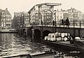
Canals


The Amsterdam canal system is the result of conscious city planning. In the early 17th century, when immigration was high, a detailed plan was created for the canals. Four layered (almost like a rainbow) half-circles of canals were built with their ends at the IJ bay.
The canals served for defense, water management, and transport. There were a moat and earthen dikes with gates at transit points.
Construction started in 1613 and moved from west to east like a gigantic windshield wiper. The canal construction in the southern sector was completed by 1656. After the canal was completed, residential buildings (buildings where people live) were slowly built. The eastern part of the canal plan, covering the area between the Amstel river and the IJ bay, has never been built. In the following centuries, the land was used for parks, senior citizens' homes, theatres, other public facilities, and waterways without much planning. Over the years, several canals have been filled in, becoming streets or squares, such as the Nieuwezijds Voorburgwal and the Spui.
Architecture

Amsterdam has a rich architectural history. The oldest building in Amsterdam is the Oude Kerk (English: Old Church), in the middle of the Wallen, dating to 1306. The oldest wooden building is Het Houten Huys at the Begijnhof. It was built around 1425 and is one of only two wooden buildings that still exist. It is also one of the few examples of Gothic architecture in Amsterdam. The oldest stone building of the Netherlands, the Moriaan, is built in 's-Hertogenbosch.
In the 16th century, wooden buildings were destroyed and replaced with brick ones. During this period, many buildings were built in the architectural style of the Renaissance.
In the 17th century, baroque architecture became very popular, as it was in other places in Europe. This was around the time of Amsterdam's Golden Age. The leading architects of this style in Amsterdam were Jacob van Campen, Philips Vingboons, and Daniel Stalpaert.


Around 1815, architects stopped using the baroque style and started building in different neo-styles. Most Gothic-style buildings were built during this time. They are said to be built in a neo-gothic style.
At the end of the 19th century, the Jugendstil, or Art Nouveau, style became popular and many new buildings were built in this architectural style. Since Amsterdam expanded quickly during this period, new buildings near the city center were also built in this style. The outside of the buildings designed at Amsterdamse School are unique: they are quite ornate, with oddly shaped windows and doors.
Most historic buildings in the city center and nearby are houses, such as the famous merchants' houses lining the canals.
Transportation
Bicycles and public transportation are used within the city of Amsterdam. Large freeways only exist around the city, ending at the A10 Ringroad. Driving a car through the city center is discouraged. The government is trying to get people to use cars less.
Local


Bicycles
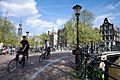
Amsterdam is known as one of the most bicycle-friendly cities in the world and is a center of bicycle culture. 38% of all journeys in the city are made by bicycle. Most main streets have bike paths. Bike racks are seen almost everywhere throughout the city. Amsterdam contains about 1,000,000 bicycles. Each year, about 100,000 of them are stolen, and 25,000 end up in the canals.
Boats
Amsterdam has a large collection of canals. There are over 150 of these waterways that crisscross the city and its surroundings, dividing the city of Amsterdam into approximately 90 mini islands. This group of islands is joined together by over 1,200 bridges. For many centuries, these canals or waterways were used as the main transportation routes in Amsterdam. Everything ranging from water to coal, from food to spices used to be transported over these canals. Today the canals are only used by smaller barges, pleasure boats, and canal tour boats. DHL is the exception: it has its own DHL parcel boats that deliver packages across town using the old waterways.
Public Transportation
Public transportation in Amsterdam consists of metro, tram, bus, and ferry routes operated mainly by GVB, the city-owned public transport operator.
Cars
Transportation by car is discouraged by the local government with expensive parking fees. Many streets are closed off for cars in the city center. The A10 Ringroad surrounding the city connects Amsterdam with the Dutch national network of freeways.
Railway
There are twelve train stations in Amsterdam.
International

Eurolines has buses from Amsterdam to destinations all over Europe that depart from Duivendrecht railway station. IDBUS operates buses from Amsterdam to Lille and Paris, departing from Amsterdam Sloterdijk railway station. Megabus operates buses from Amsterdam to London and other UK cities, departing from Zeeburg P&R site, on Tram 26 (Stop Zuiderzeeweg).
Amsterdam Schiphol Airport is less than 20 minutes by train from Amsterdam Centraal Station. It is the largest airport in the Netherlands, the 3rd largest in Europe, and the fourteenth largest in the world. It handles about 68 million passengers a year (2017). It is also home base to KLM, part of Air France-KLM since 2004.
The nearby port city of IJmuiden is a popular travel choice for those wishing to visit Amsterdam. DFDS Seaways is one of the main companies to operate in and out of IJmuiden.
Interesting facts about Amsterdam
- Amsterdam has more canals and more bridges than Venice.
- It has over 2,500 houseboats.
- Poezenboot, or Catboat, is a houseboat for abandoned cats.
- People are not allowed to smoke in cafés, restaurants, trains, stations, and waiting areas.
- Many houses are tall and narrow in Amsterdam because in the 17th century, the width of someone's house determined how much tax they had to pay. The owners of wider houses paid higher taxes.
- Famous artist Claude Monet painted the South Church 13 times.
- Rembrandt lived in Amsterdam for a time.
- Anne Frank and her family hid in a secret annex for two years before they were captured by Nazis.
- Her diary has been translated into about 70 different languages.
- There are still 8 windmills in Amsterdam.
Aalsmeer · Alkmaar · Amstelveen · Amsterdam · Andijk · Anna Paulowna · Beemster · Bennebroek · Bergen · Beverwijk · Blaricum · Bloemendaal · Bussum · Castricum · Den Helder · Diemen · Drechterland · Edam-Volendam · Enkhuizen · Graft-De Rijp · Haarlem · Haarlemmerliede en Spaarnwoude · Haarlemmermeer · Harenkarspel · Heemskerk · Heemstede · Heerhugowaard · Heiloo · Hilversum · Hoorn · Huizen · Koggenland · Landsmeer · Langedijk · Laren · Medemblik · Muiden · Naarden · Niedorp · Oostzaan · Opmeer · Spanbroek · Ouder-Amstel · Purmerend · Schagen · Schermer · Stede Broec · Texel · Uitgeest · Uithoorn · Velsen · Waterland · Weesp · Wervershoof · Wieringen · Wieringermeer · Wijdemeren · Wormerland · Zaanstad · Zandvoort · Zeevang · Zijpe
Images for kids
-
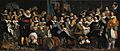
Amsterdam citizens celebrating the Peace of Münster, January 30, 1648. Painting by Bartholomeus van der Helst.
-
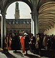
Courtyard of the Amsterdam Stock Exchange by Emanuel de Witte, 1653. The Amsterdam Stock Exchange was the first stock exchange to introduce continuous trade in the early 17th century.
-
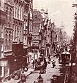
View of Vijzelstraat looking towards the Muntplein, 1891
-
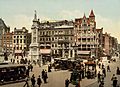
Photochrom of Amsterdam's Dam Square at the beginning of the 20th century
-
The rebuilt Magere Brug, around 1938
-
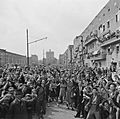
People celebrating the liberation of the Netherlands at the end of World War II on May 8, 1945
-
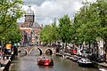
The 17th-century Canals of Amsterdam were listed as UNESCO World Heritage Sites in 2010, contributing to Amsterdam's fame as the "Venice of the North." Along with De Wallen, the canals are the focal point for tourists in the city.
-
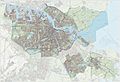
Topographic map of Amsterdam
-
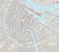
Large-scale map of the city center of Amsterdam, including sightseeing markers, as of April 2017[update].
-
The Westerkerk in the Centrum borough, one of Amsterdam's best-known churches
-
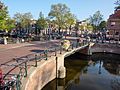
The Egelantiersgracht lies west of the Grachtengordel, in the Jordaan neighborhood.
-
The Amsterdam Stock Exchange, the oldest stock exchange in the world
-
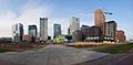
The Zuidas, the city's main business district
-
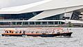
Boats give tours of the city, such as this one in front of the EYE Film Institute Netherlands.
-
Spiegelgracht
-

An Amsterdammer waits for a traffic light to change at the Muntplein in the heart of Amsterdam.
-
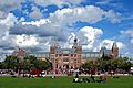
The Rijksmuseum houses Rembrandt's The Night Watch.
-

The Van Gogh Museum houses the world's largest collection of Van Gogh's paintings and letters.
-

The Stedelijk Museum Amsterdam is an international museum dedicated to modern and contemporary art and design.
-
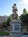
Rembrandt monument on Rembrandtplein
-
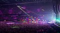
Coldplay performing at the Amsterdam Arena, 2016
-
The Concertgebouw or Royal Concert Hall houses performances of the Royal Concertgebouw Orchestra and other musical events.
-
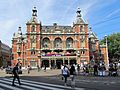
Stadsschouwburg, Amsterdam's best-known theatre
-
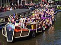
One of the decorated boats participating in the 2013 Canal Parade of the Amsterdam Gay Pride
-

AFC Ajax player Johan Cruyff, 1967
-
A tram crossing the Keizersgracht
-
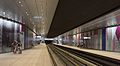
The Amsterdam Metro is a mixed subway and above ground rapid transit system consisting of five lines.
-
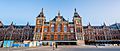
Amsterdam Centraal station, the city's main train station
-
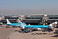
Amsterdam Airport Schiphol ranks as Europe's third-busiest airport for passenger traffic.
-
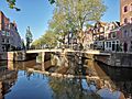
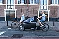
Police bicyclist crossing a bridge over the Prinsengracht
-
Bicyclist at Amsterdam
-
The Agnietenkapel Gate at the University of Amsterdam, founded in 1632 as the Athenaeum Illustre


.jpg)


.jpg)


See also
 In Spanish: Ámsterdam para niños
