
Bangkok facts for kids
Quick facts for kids
Bangkok
กรุงเทพมหานคร
|
|||
|---|---|---|---|
| Krung Thep Maha Nakhon | |||

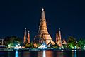
Clockwise from top: Si Lom – Sathon business district, Wat Arun, Giant Swing, Victory Monument, and Wat Phra Kaew
|
|||
|
|||
| Country | Thailand | ||
| Settled | Ayutthaya Period | ||
| Founded as capital | 21 April 1782 | ||
| Government | |||
| • Type | Special administrative area | ||
| Area | |||
| • City | 1,568.737 km2 (605.693 sq mi) | ||
| • Metro | 7,761.50 km2 (2,996.73 sq mi) | ||
| Population
(2010 (Census))
|
|||
| • City | 12,000,000 | ||
| • Density | 5,258.60/km2 (13,619.7/sq mi) | ||
| • Metro | 14,565,520 | ||
| • Metro density | 1,876.64/km2 (4,860.5/sq mi) | ||
| • Demonym | BangkokianBangkoker | ||
| Human Development Index | |||
| • HDI (2009) | 0.933 (very high) (1st) | ||
| Time zone | UTC+7 (Thailand) | ||
| Area code(s) | +66-2 | ||
| ISO 3166-2 | TH-10 | ||
| Airport Suvarnabhumi | IATA: BKK – ICAO: VTBS | ||
| Airport Don Muang | IATA: DMK – ICAO: VTBD | ||
| Website | http://www.bangkok.go.th | ||


Bangkok (Thai: กรุงเทพมหานคร) is the capital city of the Asian country Thailand. In 2010, the city had a population of 9,100,000 people. In Thailand Bangkok is known as Krung Thep or, its full name; Krung Thep Mahanakhon Amon Rattanakosin Mahinthara Yuthaya Mahadilok Phop Noppharat Ratchathani Burirom Udomratchaniwet Mahasathan Amon Piman Awatan Sathit Sakkathattiya Witsanukam Prasit. Nicknames for Bangkok are the City of Angels and the Big Mango.
Bangkok has a tropical savanna climate (Aw in the Koeppen climate classification).
Contents
History
.jpg)
The history of Bangkok dates at least back to the early 15th century, when it was a village on the west bank of the Chao Phraya River, under the rule of Ayutthaya. Because of its strategic location near the mouth of the river, the town gradually increased in importance. Bangkok initially served as a customs outpost with forts on both sides of the river, and became the site of a siege in 1688 in which the French were expelled from Siam. After the fall of Ayutthaya to the Burmese Empire in 1767, the newly declared King Taksin established his capital at the town, which became the base of the Thonburi Kingdom. In 1782, King Phutthayotfa Chulalok (Rama I) succeeded Taksin, moved the capital to the eastern bank's Rattanakosin Island, thus founding the Rattanakosin Kingdom. The City Pillar was erected on 21 April, which is regarded as the date of foundation of the present city.
Bangkok's economy gradually expanded through busy international trade, first with China, then with Western merchants returning in the early-to-mid 19th century. Following the United States' withdrawal from Vietnam in 1973, Japanese businesses took over as leaders in investment, and the expansion of export-oriented manufacturing led to growth of the financial market in Bangkok. Rapid growth of the city continued through the 1980s and early 1990s, until it was stalled by the 1997 Asian financial crisis. By then, many public and social issues had emerged, among them the strain on infrastructure reflected in the city's notorious traffic jams.
Geography

The Bangkok city proper covers an area of 1,568.737 square kilometres (605.693 sq mi), ranking 69th among the other 76 provinces of Thailand. Of this, about 700 square kilometres (270 sq mi) form the built-up urban area. It is ranked 73rd in the world in terms of land area by City Mayors. The city's urban sprawl reaches into parts of the six other provinces it borders, namely, in clockwise order from northwest: Nonthaburi, Pathum Thani, Chachoengsao, Samut Prakan, Samut Sakhon and Nakhon Pathom. With the exception of Chachoengsao, these provinces, together with Bangkok, form the greater Bangkok Metropolitan Region.
Topography
Bangkok is in the Chao Phraya River delta in Thailand's central plains. The river meanders through the city in a southward direction, emptying into the Gulf of Thailand approximately 25 kilometres (16 mi) south of the city centre. The area is flat and low-lying, with an average elevation of 1.5 metres (4 ft 11 in) above sea level. Most of the area was originally swampland, which was gradually drained and irrigated for agriculture via the construction of canals (khlong) which took place throughout the 16th to 19th centuries. The course of the river as it flows through Bangkok has been modified by the construction of several shortcut canals.

This intricate waterway network served as the primary mode of transport up until the late 19th century, when modern roads began to be built. Up until then, most people lived near or on the water, leading the city to be known during the 19th century as the "Venice of the East". Many of these canals have since been filled in or paved over, but others still criss-cross the city, serving as major drainage channels and transport routes. Most canals are now badly polluted, although the BMA has committed to the treatment and cleaning up of several canals.
The geology of the Bangkok area is characterized by a top layer of soft marine clay known as Bangkok clay, averaging 15 metres (49 ft) in thickness, which overlies an aquifer system consisting of eight known units. This feature has contributed to the effects of subsidence caused by extensive ground water pumping. First recognized in the 1970s, subsidence soon became a critical issue, reaching a rate of 120 millimetres (4.7 in) per year in 1981.
Subsidence has resulted in increased flood risk, as Bangkok is already prone to flooding due to its low elevation and inadequate drainage infrastructure resulting from rapid urbanization. The city now relies on flood barriers and augmenting drainage from canals by pumping and building drain tunnels, but parts of Bangkok and its suburbs are still regularly affected by flooding.
There are no mountains in Bangkok, the closest mountain range being the Khao Khiao Massif, located about 40 km (25 mi) southeast of the city. Phu Khao Thong, the only hill in the metropolitan area, originated in a very large chedi that King Rama III (1787–1851) decided to build at Wat Saket. The chedi collapsed during construction because the soft soil of Bangkok could not support the weight. Over the next few decades, the abandoned mud-and-brick structure acquired the shape of a natural hill and became overgrown with weeds. The locals called it "phu khao" (ภูเขา), as if it were a natural feature. In the 1940s surrounding concrete walls were added to stop the hill from eroding.
Climate
Like most of Thailand, Bangkok has a tropical savanna climate under the Köppen climate classification and is under the influence of the South Asian monsoon system. It experiences three seasons, hot, rainy and cool, although temperatures are fairly hot year-round, ranging from an average low of 22.0 °C (71.6 °F) in December to an average high of 35.4 °C (95.7 °F) in April. The rainy season begins with the arrival of the southwest monsoon around mid-May. September is the wettest month, with an average rainfall of 334.3 millimetres (13.16 in). The rainy season lasts until October, when the dry and cool northeast monsoon takes over until February. The hot season is generally dry, but also sees occasional summer storms. The surface magnitude of Bangkok's urban heat island has been measured at 2.5 °C (4.5 °F) during the day and 8.0 °C (14 °F) at night. The highest recorded temperature of Bangkok metropolis was 40.0 °C (104.0 °F) in April 1979, and the lowest recorded temperature was 9.9 °C (49.8 °F) in January 1955.
Districts
Bangkok's fifty districts serve as administrative subdivisions under the authority of the BMA. Thirty-five of these districts lie to the east of the Chao Phraya, while fifteen are on the western bank, known as the Thonburi side of the city.
Cityscape
Bangkok's district areas often do not accurately represent the functional divisions of its neighbourhoods or actual land uses. Although urban planning policies date back to the commission of the "Litchfield plan" in 1960, which set out strategies for land use, transportation and general infrastructure improvements, actual zoning regulations were not fully implemented until 1992. As a result, the city grew organically throughout the period of its rapid expansion, both horizontally as ribbon developments extended along newly built roads, and vertically, with increasing numbers of high rises and skyscrapers being built in several commercial areas. The city has grown from its original centre along the river into a sprawling metropolis surrounded by swaths of suburban residential development extending north and south into neighbouring provinces.

Bangkok's historic centre remains the Rattanakosin Island in Phra Nakhon District. It is the site of the Grand Palace and the City Pillar Shrine, primary landmarks of the city's foundation, as well as many important Buddhist temples. Phra Nakhon, along with the neighbouring Pom Prap Sattru Phai and Samphanthawong Districts, formed what was the city proper in the later 19th century. Many traditional neighbourhoods and markets are located here, including the Chinese settlement of Sampheng. The city was expanded toward Dusit District in the early 19th century, following King Chulalongkorn's relocation of the royal household to the new Dusit Palace. The area is the site of the country's seats of power as well as the city's most popular tourist landmarks.
_cropped.jpg)
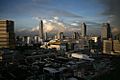
In contrast with the low-rise historic areas, the business district on Si Lom and Sathon Roads in Bang Rak and Sathon Districts teems with skyscrapers.
Bangkok lacks a single distinct central business district. Instead, the areas of Siam and Ratchaprasong serve as a "central shopping district" containing many of the bigger malls and commercial areas in the city, as well as Siam Station, the only transfer point between the city's two elevated train lines. The Victory Monument in Ratchathewi District is among its most important road junctions, serving over 100 bus lines as well as an elevated train station. From the monument, Phahonyothin and Ratchawithi / Din Daeng Roads respectively run northward and eastward linking to major residential areas. Most high-density development is located within the 113-square-kilometre (44 sq mi) area encircled by the Ratchadaphisek inner ring road. Ratchadaphisek is lined with businesses and retail outlets, and office buildings also concentrate around Ratchayothin Intersection in Chatuchak District to the north. Farther from the city centre, most areas are primarily mid- or low-density residential. The Thonburi side of the city is less developed, with fewer high rises. With the exception of a few secondary urban centres, Thonburi, as well as the outlying eastern districts, consist mostly of residential and rural areas.
Parks and green zones

Bangkok has several parks, although these amount to a per-capita total park area of only 1.82 square metres (19.6 sq ft) in the city proper. Total green space for the entire city is moderate, at 11.8 square metres (127 sq ft) per person; however, in the more densely built-up areas of the city these numbers are as low as 1.73 and 0.72 square metres (18.6 and 7.8 sq ft) per person. More recent numbers claim that there is only 3.3 m2 of green space per person, compared to an average of 39 m2 in other cities across Asia. In Europe, London has 33.4 m2 of green space per head. Bangkokians thus have 10 times less green space than is standard in the region's urban areas. Green belt areas include about 700 square kilometres (270 sq mi) of rice paddies and orchards in the eastern and western edges of the city proper, although their primary purpose is to serve as flood detention basins rather than to limit urban expansion. Bang Kachao, a 20-square-kilometre (7.7 sq mi) conservation area in an oxbow of the Chao Phraya, lies just across the southern riverbank districts, in Samut Prakan Province. A master development plan has been proposed to increase total park area to 4 square metres (43 sq ft) per person.
Bangkok's largest parks include the centrally located Lumphini Park near the Si Lom – Sathon business district with an area of 57.6 hectares (142 acres), the 80-hectare (200-acre) Suanluang Rama IX in the east of the city, and the Chatuchak–Queen Sirikit–Wachirabenchathat park complex in northern Bangkok, which has a combined area of 92 hectares (230 acres).
Demography
The city of Bangkok has a population of 8,280,925 according to the 2010 census, or 12.6 percent of the national population. However, there are only 5,692,284 registered residents, belonging to 2,672,423 households. A large number of Bangkok's daytime population commutes from surrounding provinces in the Bangkok Metropolitan Region, the total population of which is 14,565,547. Bangkok is a cosmopolitan city; the census showed that it is home to 81,570 Japanese and 55,893 Chinese nationals, as well as 117,071 expatriates from other Asian countries, 48,341 from Europe, 23,418 from the Americas, 5,289 from Australia and 3,022 from Africa. Immigrants from neighbouring countries include 303,595 Burmese, 63,438 Cambodians and 18,126 Lao.

The majority of Bangkok's population are of Thai ethnicity. Thai ethnicity is rather a question of cultural identity than of genetic origin. Many people in Bangkok who self-identify as Thai have at least some Chinese ancestry. although details on the city's ethnic make-up are unavailable, as the national census does not document race. The majority (91 percent) of the city's population is Buddhist. Other religions include Islam (4.7%), Christianity (2.0%), Hinduism (0.5%), Sikhism (0.1%) and Confucianism (0.1%).
Economy

Bangkok is the economic centre of Thailand, and the heart of the country's investment and development. In 2010, the city had an economic output of 3.142 trillion baht (98.34 billion US dollars), contributing 29.1 percent of the gross domestic product (GDP).
Wholesale and retail trade is the largest sector in the city's economy, contributing 24.0 percent of Bangkok's gross provincial product. It is followed by manufacturing (14.3%); real estate, renting and business activities (12.4%); transport and communications (11.6%); and financial intermediation (11.1%). Bangkok alone accounts for 48.4 percent of Thailand's service sector, which in turn constitutes 49.0 percent of GDP. When the Bangkok Metropolitan Region is considered, manufacturing is the most significant contributor at 28.2 percent of the gross regional product, reflecting the density of industry in the Bangkok's neighbouring provinces. The automotive industry based around Greater Bangkok is the largest production hub in Southeast Asia. Tourism is also a significant contributor to Bangkok's economy, generating ฿427.5bn ($13.38bn) in revenue in 2010.

Bangkok is home to the headquarters of all of Thailand's major commercial banks and financial institutions, as well as the country's largest companies. A large number of multinational corporations base their regional headquarters in Bangkok due to the lower cost of the workforce and firm operations relative to other major Asian business centres. Seventeen Thai companies are listed on the Forbes 2000, all of which are based in the capital, including PTT, the only Fortune Global 500 company in Thailand.
Tourism

Bangkok is one of the world's top tourist destination cities. MasterCard ranked Bangkok as the top destination city by international visitor arrivals in its Global Destination Cities Index 2016, ahead of London with more than 21 million overnight visitors. Euromonitor International ranked Bangkok fourth in its Top City Destinations Ranking for 2016. Bangkok was also named "World's Best City" by Travel + Leisure magazine's survey of its readers for four consecutive years, from 2010 to 2013.
As the main gateway through which visitors arrive in Thailand, Bangkok is visited by the majority of international tourists to the country. Domestic tourism is also prominent. The Department of Tourism recorded 26,861,095 Thai and 11,361,808 foreign visitors to Bangkok in 2010. Lodgings were made by 15,031,244 guests, who occupied 49.9 percent of the city's 86,687 hotel rooms.
Bangkok's multi-faceted sights, attractions and city life appeal to diverse groups of tourists. Royal palaces and temples as well as several museums constitute its major historical and cultural tourist attractions. Shopping and dining experiences offer a wide range of choices and prices. The city is also famous for its dynamic nightlife.

Among Bangkok's well-known sights are the Grand Palace and major Buddhist temples, including Wat Phra Kaew, Wat Pho, and Wat Arun. The Giant Swing and Erawan Shrine demonstrate Hinduism's deep-rooted influence in Thai culture. Vimanmek Mansion in Dusit Palace is famous as the world's largest teak building, while the Jim Thompson House provides an example of traditional Thai architecture. Other major museums include the Bangkok National Museum and the Royal Barge National Museum. Cruises and boat trips on the Chao Phraya and Thonburi's canals offer views of some of the city's traditional architecture and ways of life on the waterfront.
Culture
The culture of Bangkok reflects its position as Thailand's centre of wealth and modernisation. The city has long been the portal of entry of Western concepts and material goods, which have been adopted and blended with Thai values to various degrees by its residents. This is most evident in the lifestyles of the expanding middle class. Conspicuous consumption serves as a display of economic and social status, and shopping centres are popular weekend hangouts. Ownership of electronics and consumer products such as mobile phones is ubiquitous. This has been accompanied by a degree of secularism, as religion's role in everyday life has rather diminished. Although such trends have spread to other urban centres, and, to a degree, the countryside, Bangkok remains at the forefront of social change.
A distinct feature of Bangkok is the ubiquity of street vendors selling goods ranging from food items to clothing and accessories.
Festivals and events

The residents of Bangkok celebrate many of Thailand's annual festivals. During Songkran on 13–15 April, traditional rituals as well as water fights take place throughout the city. Loi Krathong, usually in November, is accompanied by the Golden Mount Fair. New Year celebrations take place at many venues, the most prominent being the plaza in front of CentralWorld. Observances related to the royal family are held primarily in Bangkok. Wreaths are laid at King Chulalongkorn's equestrian statue in the Royal Plaza on 23 October, which is King Chulalongkorn Memorial Day. The present king's and queen's birthdays, respectively on 5 December and 12 August, are marked as Thailand's national Father's Day and national Mother's Day. These national holidays are celebrated by royal audiences on the day's eve, in which the king or queen gives a speech, and public gatherings on the day of the observance. The king's birthday is also marked by the Royal Guards' parade.
Sanam Luang is the site of the Thai Kite, Sport and Music Festival, usually held in March, and the Royal Ploughing Ceremony which takes place in May. The Red Cross Fair at the beginning of April is held at Suan Amporn and the Royal Plaza, and features numerous booths offering goods, games and exhibits. The Chinese New Year (January–February) and Vegetarian Festival (September–October) are celebrated widely by the Chinese community, especially in Yaowarat.
Art

Traditional Thai art, long developed within religious and royal contexts, continues to be sponsored by various government agencies in Bangkok, including the Department of Fine Arts' Office of Traditional Arts. The SUPPORT Foundation in Chitralada Palace sponsors traditional and folk handicrafts. Various communities throughout the city still practice their traditional crafts, including the production of khon masks, alms bowls, and classical musical instruments. The National Gallery hosts permanent collection of traditional and modern art, with temporary contemporary exhibits. Bangkok's contemporary art scene has slowly grown from relative obscurity into the public sphere over the past two decades. Private galleries gradually emerged to provide exposure for new artists, including the Patravadi Theatre and H Gallery. The centrally located Bangkok Art and Culture Centre, opened in 2008 following a fifteen-year lobbying campaign, is now the largest public exhibition space in the city. There are also many other art galleries and museums, including the privately owned Museum of Contemporary Art.
Sport

Modern Bangkok has developed a strong spectator sport culture. While muay Thai kickboxing matches at Rajadamnern and Lumpini Stadiums are regularly broadcast on television, the sport has mostly been overtaken in popularity by association football. Several foreign leagues and competitions, especially England's Premier League, have large followings in Bangkok as well as other Thai urban centres. In recent years, the Thai Premier League has been gaining popularity. BEC–Tero Sasana based in Bangkok and Muangthong United based in the Bangkok Metropolitan Region are leading clubs.
Transport

Although Bangkok's canals historically served as a major mode of transport, they have long since been surpassed in importance by land traffic. Charoen Krung Road, the first to be built by Western techniques, was completed in 1864. Since then, the road network has vastly expanded to accommodate the sprawling city. A complex elevated expressway network helps bring traffic into and out of the city centre, but Bangkok's rapid growth has put a large strain on infrastructure, and traffic jams have plagued the city since the 1990s. Although rail transport was introduced in 1893 and electric trams served the city from 1894 to 1968, it was only in 1999 that Bangkok's first rapid transit system began operation. Older public transport systems include an extensive bus network and boat services which still operate on the Chao Phraya and two canals. Taxis appear in the form of cars, motorcycles, and "tuk-tuk" auto rickshaws.
Bangkok is connected to the rest of the country through the national highway and rail networks, as well as by domestic flights to and from the city's two international airports. Its centuries-old maritime transport of goods is still conducted through Khlong Toei Port.

International relations
The city's formal international relations are managed by the International Affairs Division of the BMA. Its missions include facilitating cooperation with other major cities through sister city agreements, participation and membership in international organizations, and pursuing cooperative activities with the many foreign diplomatic missions based in the city.
International participation
Bangkok is a member of several international organizations and regional city government networks, including the Asian Network of Major Cities 21, the Japan-led Asian-Pacific City Summit, the C40 Cities Climate Leadership Group, the ESCAP-sponsored Regional Network of Local Authorities for Management of Human Settlements in Asia and Pacific (CITYNET), Japan's Council of Local Authorities for International Relations, the World Association of the Major Metropolises and Local Governments for Sustainability, among others.
Sister cities
Bangkok has made sister city and/or friendship agreements with twenty-seven other cities in sixteen countries, as of 2016[update]. They are:
|
|
Images for kids
-
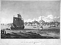
Engraving of the city from British diplomat John Crawfurd's embassy in 1822
-
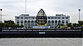
The city's ceremonial name is displayed in front of Bangkok City Hall.
-
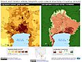
Bangkok population density and low elevation coastal zones. Bangkok is especially vulnerable to sea level rise.
-
.
labelled version showing subdistricts]])
-
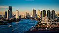
View of the Chao Phraya River as it passes through Bang Kho Laem and Khlong San districts
-
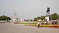
The Royal Plaza in Dusit District was inspired by King Chulalongkorn's visits to Europe.
-
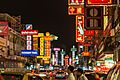
Yaowarat Road, the centre of Bangkok's Chinatown. Chinese immigrants historically formed the majority of the city's population.
-
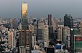
MahaNakhon, the city's tallest building from 2016 to 2018, stands among the skyscrapers of Sathon Road, one of Bangkok's main financial districts.
-
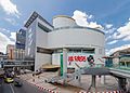
The Siam area is home to multiple shopping centres catering to both the middle and upper classes and tourists.
-
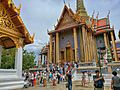
Wat Phra Kaew in the Grand Palace is among Bangkok's major tourist attractions.
-
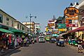
Khao San Road is lined by budget accommodation, shops and bars catering to tourists.
-
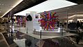
Temporary art display at Siam Discovery during the Bangkok Art Biennale 2018
-
The Bangkok Art and Culture Centre, the city's major public contemporary art venue, was opened in 2008 after many delays.
-
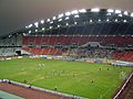
Rajamangala Stadium was built for the 1998 Asian Games and Thailand national football team home stadium.
-
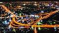
Streetlamps and headlights illuminate the Makkasan Interchange of the expressway. The system sees a traffic of over 1.5 million vehicles per day.
-
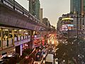
Traffic jams, seen here on Sukhumwit Road, are common in Bangkok.
-
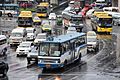
Many buses, minibuses and taxis share the streets with private vehicles at Victory Monument, a major public transport hub.
-
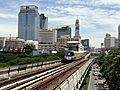
A BTS train departs from Ratchadamri station, towards Siam station.
-
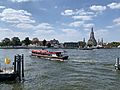
A Chao Phraya Express Boat on the Chao Phraya near Wat Arun
-
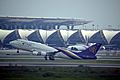
Suvarnabhumi Airport is home to flag carrier Thai Airways International.
-
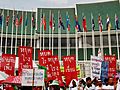
Protesters in front of the United Nations Building during the 2009 Bangkok Climate Change Conference. Bangkok is home to several UN offices.
-
Wat Arun


.jpg)
.jpg)
_(cropped).jpg)
.jpg)
.jpg)

.jpeg)
.jpg)

.jpg)

_(cropped).jpg)


.jpg)
_-_img_05.jpg)
.jpg)


See also
 In Spanish: Bangkok para niños
