
Burundi facts for kids
Quick facts for kids
Republic of Burundi
|
|
|---|---|
 Coat of arms
|
|
|
Motto: "Ubumwe, Ibikorwa, Iterambere" (Kirundi)
"Unité, Travail, Progrès" (French) "Unity, Work, Progress" 1 |
|
|
Anthem: Burundi bwacu
(Our Burundi) |
|
![Location of Burundi (dark blue)– in Africa (light blue & dark grey)– in the African Union (light blue) — [Legend]](/Image:Location_Burundi_AU_Africa.svg)
Location of Burundi (dark blue)
– in Africa (light blue & dark grey) |
|
| Capital and largest city
|
Bujumbura |
| Official languages | Kirundi French |
| Vehicular languages | Kirundi, Swahili |
| Ethnic groups | Hutu (Bantu) 85% Tutsi (Hamitic) 14% Twa (Pygmy) 1% Europeans 3,000 South Asians 2,000 |
| Demonym(s) | Burundian |
| Government | Republic |
| Pascal Nyabenda (acting) | |
| Gaston Sindimwo | |
| Joseph Butore | |
| Independence | |
|
• from Belgium
|
July 1, 1962 |
| Area | |
|
• Total
|
27,834 km2 (10,747 sq mi) (145th) |
|
• Water (%)
|
7.8 |
| Population | |
|
• 2011 estimate
|
10,216,190 (89th) |
|
• 2008 census
|
8,053,574 |
|
• Density
|
367.0/km2 (950.5/sq mi) (45th) |
| GDP (PPP) | 2010 estimate |
|
• Total
|
$3.397 billion |
|
• Per capita
|
$410 |
| GDP (nominal) | 2010 estimate |
|
• Total
|
$1.489 billion |
|
• Per capita
|
$180 |
| Gini (1998) | 42.4 medium |
| HDI (2010) | low · 166th |
| Currency | Burundi franc (FBu) (BIF) |
| Time zone | UTC+2 (CAT) |
|
• Summer (DST)
|
UTC+2 (not observed) |
| Driving side | right |
| Calling code | 257 |
| ISO 3166 code | BI |
| Internet TLD | .bi |
|
|

Burundi (officially called Republic of Burundi) is a small country in Africa. The capital of Burundi is Bujumbura. The official languages of Burundi are Kirundi and French. There are about eight and a half million people in Burundi. Burundi is one of the poorest countries in the world.
Contents
Provinces, communes and collines
Burundi is divided into 17 provinces, 117 communes, and 2,638 collines (hills). Provincial governments are based on these boundaries. In 2000, the province encompassing Bujumbura was separated into two provinces, Bujumbura Rural and Bunjumbura Mairie.
The provinces are:
Largest cities
These are the largest cities in Burundi:
| Ranking | Name | Population |
|---|---|---|
| 1. | Bujumbura | 340,300 |
| 2. | Gitega | 46,900 |
| 3. | Muyinga | 45,300 |
| 4. | Ngozi | 40,200 |
| 5. | Ruyigi | 36,800 |
| 6. | Kayanza | 26,200 |
| 7. | Bururi | 22,900 |
| 8. | Rutana | 20,700 |
| 9. | Muramvya | 17,600 |
| 10. | Makamba | 13,000 |
Geography
One of the smallest countries in Africa, Burundi is landlocked. It is bordered by Rwanda in the north, Tanzania in the east and south and the Democratic Republic of the Congo in the west. It has an equatorial climate. Burundi is a part of the Albertine Rift, the western extension of the East African Rift. The country lies on a rolling plateau in the center of Africa. The average elevation of the central plateau is 5,600 feet (1,707 m), with lower elevations at the borders. The highest peak, Mount Heha at 8,810 feet (2,685 m), is southeast of the capital, Bujumbura. The source of the Nile River is in Burundi province. It is linked from Lake Victoria to its headwaters by the Ruvyironza River Lake Victoria is also an important water source. It serves as a fork to the Kagera River. Another major lake is Lake Tanganyika, in Burundi's southwestern corner.
Burundi's lands are mostly agricultural or pasture. Settlement by rural populations has led to deforestation, soil erosion and habitat loss.
There are two national parks: Kibira National Park and Ruvubu National Park. Both were formed in 1982to keep wildlife populations.
Related pages
Images for kids
-
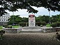
Independence Square and monument in Bujumbura.
-
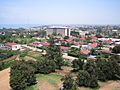
View of the capital city Bujumbura in 2006.
-
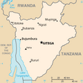
Map of Burundi.
-
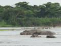
Hippos at Kibira National Park in the Northwest of Burundi
-
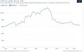
Historical development of GDP per capita
-
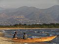
Fishermen on Lake Tanganyika.
-
Bujumbura International Airport terminal in Bujumbura
-
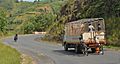
Bicycles are a popular means of transport in Burundi
-
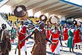
Men in colourful clothing with drums
-
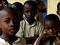
Children in Bujumbura, Burundi
-
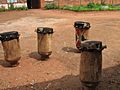
Drums from Gitega.
-
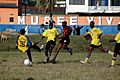
Football in Burundi.
-
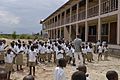
Carolus Magnus School in Burundi. The school benefits from the campaign "Your Day for Africa" by Aktion Tagwerk.


See also
 In Spanish: Burundi para niños
