
Colstrip, Montana facts for kids
Quick facts for kids
Colstrip, Montana
|
||
|---|---|---|

Sign upon entering Colstrip
|
||
|
||
| Motto(s):
Tomorrow's Town Today
|
||

Location of Colstrip, Montana
|
||
| Country | United States | |
| State | Montana | |
| County | Rosebud | |
| Incorporated (city) | 1998 | |
| Government | ||
| • Type | Mayor-Council | |
| Area | ||
| • Total | 4.05 sq mi (10.49 km2) | |
| • Land | 4.05 sq mi (10.48 km2) | |
| • Water | 0.01 sq mi (0.02 km2) | |
| Elevation | 3,222 ft (982 m) | |
| Population
(2020)
|
||
| • Total | 2,096 | |
| • Density | 517.53/sq mi (200.00/km2) | |
| Time zone | UTC-7 (Mountain (MST)) | |
| • Summer (DST) | UTC-6 (MDT) | |
| ZIP code |
59323
|
|
| Area code(s) | 406 Exchange: 768 | |
| FIPS code | 30-16525 | |
| GNIS feature ID | 0770042 | |
| Website | http://www.cityofcolstrip.com/ | |

Colstrip is a city in Rosebud County, Montana, United States. The population was 2,096 at the 2020 census. Established in 1924 and incorporated as a city in 1998, Colstrip is the largest city in Rosebud County with 25.2% of the total population. Colstrip's primary industries are coal mining and electricity production. In 2005, Sports Illustrated’s 50th anniversary issue named Colstrip the top sports town in Montana. The entire community celebrates Colstrip Days annually on the weekend prior to the 4th of July.
Contents
History

Colstrip was established by the Northern Pacific Railway in 1924 as a company town to provide coal for their steam locomotives. The mining at Rosebud Mine two miles south of the town is open pit strip mining, where draglines remove soil above the layer of bituminous coal from the Fort Union Formation.
During World War II, the Colstrip mine was identified as strategically important because it supplied coal for the Northern Pacific Railway steam locomotives hauling military equipment for the war effort. The mine was guarded from sabotage, and the employees were not allowed to quit their jobs.
In 1958 the railroad switched to using diesel locomotives and the Colstrip mine was shut down. In 1959 Montana Power Company purchased the rights to the mine and the town, and resumed mining operations in the 1970s with plans to build coal-fired electrical plants.

The power plants were built in the 1970s and 1980s by a collection of contractors including Bechtel. During this construction period Colstrip was a boomtown, with a large increase in population. Plants 1 & 2 were operational in 1975 and 1976, and plants 3 & 4 were operational in 1984 and 1986.

In 1974 construction of Colstrip's 150-acre (0.61 km2) Castle Rock Lake (formerly named surge pond) was completed. The Colstrip plants produce electricity from coal using steam. The water for the steam is pumped in an underground pipe 30 miles (48 km) from the Yellowstone River and stored in the lake. The lake is stocked with fish and the home for a wide variety of wildlife.
In 1990 the Colstrip Energy Limited Project started commercial operations. Located six miles (10 km) north of Colstrip, this experimental electricity production facility is owned by Rosebud Energy Corp., a partnership that at one point included Enron. The plant uses high sulfur waste coal from the Rosebud Coal Mine's topmost one foot layer of coal.
In 1998 plants 1-4 were sold to a group led by PPL Corporation (PPL)
and Puget Sound Energy (PSE). The Rosebud Coal Mine was sold to Westmoreland Mining LLC.
In this same year the City of Colstrip was incorporated.
As of June 2015, PPL spun off its power generation assets including the Colstrip plants to become Talen Energy.
In 2016, Puget Sound Energy reached an agreement with the Sierra Club and the Montana Environmental Information Center to shut down units 1 and 2 of the coal-fired generating plant by the year 2022. The agreement says nothing about the status of Units 3 and 4 at the generating station. However, the existing electrical transmission capacity that transmits power from Colstrip to the Pacific Northwest may be used to transmit wind energy.
Colstrip is the proposed junction point of the BNSF Railway's trackage through the city with the proposed Tongue River Railroad south to new coal mines near the Wyoming border.
Geography
Colstrip is located at 45°52′50.03″N 106°37′47.65″W / 45.8805639°N 106.6299028°W (45.880563, -106.629903).
According to the United States Census Bureau, the city has a total area of 4.47 square miles (11.58 km2), all of it land.
Demographics
| Historical population | |||
|---|---|---|---|
| Census | Pop. | %± | |
| 2000 | 2,346 | — | |
| 2010 | 2,214 | −5.6% | |
| 2020 | 2,096 | −5.3% | |
| U.S. Decennial Census | |||
The historical population of Colstrip has varied largely since it was established in 1924. Prior to incorporation in 1998 it was a census-designated place.
2010 census
As of the census of 2010, there were 2,214 people, 863 households, and 622 families residing in the city. The population density was 495.3 inhabitants per square mile (191.2/km2). There were 986 housing units at an average density of 220.6 per square mile (85.2/km2). The racial makeup of the city was 84.7% White, 0.2% African American, 9.0% Native American, 0.6% Asian, 0.1% Pacific Islander, 0.4% from other races, and 5.0% from two or more races. Hispanic or Latino of any race were 4.3% of the population.
There were 863 households, of which 35.9% had children under the age of 18 living with them, 61.8% were married couples living together, 5.8% had a female householder with no husband present, 4.5% had a male householder with no wife present, and 27.9% were non-families. 24.1% of all households were made up of individuals, and 5.2% had someone living alone who was 65 years of age or older. The average household size was 2.57 and the average family size was 3.06.
The median age in the city was 38.1 years. 28.2% of residents were under the age of 18; 5.9% were between the ages of 18 and 24; 24.9% were from 25 to 44; 36% were from 45 to 64; and 5.2% were 65 years of age or older. The gender makeup of the city was 51.8% male and 48.2% female.
Climate
According to the Köppen Climate Classification system, Colstrip has a semi-arid climate, abbreviated "BSk" on climate maps.
| Climate data for Colstrip, Montana | |||||||||||||
|---|---|---|---|---|---|---|---|---|---|---|---|---|---|
| Month | Jan | Feb | Mar | Apr | May | Jun | Jul | Aug | Sep | Oct | Nov | Dec | Year |
| Average high °F (°C) | 34.3 (1.3) |
39 (4) |
47 (8) |
58.7 (14.8) |
68.8 (20.4) |
77.7 (25.4) |
88.1 (31.2) |
86.7 (30.4) |
75.1 (23.9) |
62.2 (16.8) |
46.6 (8.1) |
37.1 (2.8) |
60.1 (15.6) |
| Average low °F (°C) | 9.5 (−12.5) |
14.4 (−9.8) |
21.9 (−5.6) |
31.5 (−0.3) |
40.8 (4.9) |
49.3 (9.6) |
55.5 (13.1) |
53.3 (11.8) |
43.4 (6.3) |
33.3 (0.7) |
22.2 (−5.4) |
13 (−11) |
32.3 (0.2) |
| Average precipitation inches (mm) | 0.6 (15) |
0.5 (13) |
0.9 (23) |
1.6 (41) |
2.5 (64) |
2.7 (69) |
1.3 (33) |
1.1 (28) |
1.3 (33) |
1.3 (33) |
0.6 (15) |
0.6 (15) |
15 (382) |
| Average precipitation days | 6 | 5 | 7 | 7 | 10 | 9 | 6 | 5 | 5 | 5 | 5 | 5 | 75 |
| Source: Weatherbase | |||||||||||||
Notable people
- Wally McRae — Cowboy poet who earned the 1990 National Endowment for the Arts' National Heritage Award
- George Armstrong Custer — one of his final encampments before Battle of the Little Bighorn was 10 miles (16 km) south of Colstrip
- Tuff Harris — safety for the Pittsburgh Steelers, moved from Lodge Grass to play football at Colstrip High School as a sophomore
- Russ Davidson — 2013 National and Montana Outstanding Teacher of American History
Education
Colstrip Public Schools educates students from kindergarten through 12th grade. The highest level of education offered in Colstrip is the Colstrip High School. They are known as the Colts/Fillies. The nearest college is Chief Dull Knife College in Lame Deer. Colstrip is about 20 miles (32 km) north of the Northern Cheyenne Indian Reservation. Many Cheyenne students from the reservation attend school at the high school, making up about one third of the students.
The Bicentennial Library operates in Colstrip.
Infrastructure
Colstrip Airport (FAA ID: M46) is a public use airport located 3 miles (4.8 km) southwest of Colstrip.
Images for kids
-
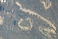
The Rosebud mine in 2006, taken from the International Space Station

See also
 In Spanish: Colstrip (Montana) para niños
