
County Waterford facts for kids
Quick facts for kids
County Waterford
Contae Phort Láirge
|
||
|---|---|---|
|
||
| Nickname(s):
The Déise
|
||
| Motto(s):
Déisi oc Declán co Bráth (Old Irish)
"May the Déise remain with Declan forever" |
||
 |
||
| Country | Ireland | |
| Province | Munster | |
| Established | 1207 | |
| County town | Waterford | |
| Government | ||
| • Type | City and County Council | |
| Area | ||
| • Total | 1,857 km2 (717 sq mi) | |
| Area rank | 20th | |
| Highest elevation | 792 m (2,598 ft) | |
| Population
(2016)
|
||
| • Total | 116,176 | |
| • Rank | 20th | |
| • Density | 62.561/km2 (162.03/sq mi) | |
| Time zone | UTC±0 (WET) | |
| • Summer (DST) | UTC+1 (IST) | |
| Eircode routing keys |
E32, E91, X35, X42, X91 (primarily)
|
|
| Telephone area codes | 051, 058 (primarily) | |
| Vehicle index mark code |
W (since 2014) WD (1987–2013) |
|

County Waterford (Irish: Contae Phort Láirge) is a county in Ireland. It is in the province of Munster and is part of the South-East Region. It is named after the city of Waterford. Waterford City and County Council is the local authority for the county. The population of the county at large, including the city, was 116,176 according to the 2016 census. The county is based on the historic Gaelic territory of the Déise. There is an Irish-speaking area, Gaeltacht na nDéise, in the south-west of the county.
Contents
Geography and political subdivisions
County Waterford has two mountain ranges, the Knockmealdown Mountains and the Comeragh Mountains. The highest point in the county is Knockmealdown, at 794m. It also has many rivers, including Ireland's third longest river, the River Suir (184 km); and Ireland's fourth longest river, the Munster Blackwater (168 km). There are over 30 coast line. A large stretch of this coastline, known as the Copper Coast has been designated as a UNESCO Geopark, a place of great geological importance. The area around Ring (An Rinn) is a Gaeltacht, an Irish-speaking area.
Waterford City is the county seat, prior to the merger of the 2 Waterford authorities in June 2014 Dungarvan was the county seat for Waterford County Council.
Baronies
There are eight historic baronies in the county: Coshmore and Coshbride, Decies-within-Drum, Decies-without-Drum, Gaultiere, Glenahiry, Middle Third, Upperthird and Waterford City.
Towns and villages
| Historical population | ||
|---|---|---|
| Year | Pop. | ±% |
| 1600 | 14,456 | — |
| 1610 | 9,887 | −31.6% |
| 1653 | 13,136 | +32.9% |
| 1659 | 13,286 | +1.1% |
| 1821 | 76,103 | +472.8% |
| 1831 | 85,217 | +12.0% |
| 1841 | 196,187 | +130.2% |
| 1851 | 164,035 | −16.4% |
| 1861 | 134,252 | −18.2% |
| 1871 | 123,310 | −8.2% |
| 1881 | 112,768 | −8.5% |
| 1891 | 98,251 | −12.9% |
| 1901 | 87,187 | −11.3% |
| 1911 | 83,966 | −3.7% |
| 1926 | 78,562 | −6.4% |
| 1936 | 77,614 | −1.2% |
| 1946 | 76,108 | −1.9% |
| 1951 | 75,061 | −1.4% |
| 1956 | 74,031 | −1.4% |
| 1961 | 71,439 | −3.5% |
| 1966 | 73,080 | +2.3% |
| 1971 | 77,315 | +5.8% |
| 1979 | 87,278 | +12.9% |
| 1981 | 88,591 | +1.5% |
| 1986 | 91,151 | +2.9% |
| 1991 | 91,624 | +0.5% |
| 1996 | 94,680 | +3.3% |
| 2002 | 101,546 | +7.3% |
| 2006 | 107,961 | +6.3% |
| 2011 | 113,795 | +5.4% |
| 2016 | 116,401 | +2.3% |
- Abbeyside, Affane, Aglish, Annestown, An Rinn, Ardmore
- Ballinacourty, Ballinameela, Ballinamult, Ballinroad, Ballybeg, Ballybricken, Ballyduff Lower, Ballyduff Upper, Ballydurn, Ballygunner, Ballylaneen, Ballymacarbry, Ballymacart, Ballynaneashagh, Ballysaggart, Ballytruckle, Bilberry, Bunmahon, Butlerstown
- Cappoquin, Carrickbeg, Carriglea, Cheekpoint, Clashmore, Clonea-Power, Clonea Strand, Colligan, Coolnasmear, Crooke
- Dungarvan, Dunhill, Dunmore East
- Dunhill
- Faha, Faithlegg, Fenor, Ferrybank, Fews, Fourmilewater
- Glencairn, Grange
- Helvick Head
- Kilbrien, Kilgobinet, Kill, Killea, Kilmacthomas, Kilmanahan, Kilmeaden, Kilrossanty, Kilwatermoy, Kinsalebeg, Knockanore
- Lemybrien, Lisduggan, Lismore
- Mahon Bridge, Mine Head, Modeligo, Mothel, Mount Congreve, Mount Mellaray
- Newtown
- Old Parish
- Passage East, Portlaw
- Rathgormack
- Sliabh gCua, Stradbally
- Tallow, Tramore, Touraneena, Tourin, Tycor
- Waterford, Whitechurch, Whiting Bay, Woodstown
- Villierstown
History
.jpg)
County Waterford is colloquially known as "The Déise", pronounced "day-sha" (Irish: An Déise). Some time between the 4th and 8th centuries, a tribe of native Gaelic people called the Déisi were driven from southern county Meath/north Kildare, conquering and settled there. The ancient principality of the Déise is today roughly coterminous with the current Roman Catholic Diocese of Waterford and Lismore thus including part of south County Tipperary.
The westernmost of the baronies are "Decies within Drum" and "Decies without Drum", separated by the Drum-Fineen hills.
There are many megalithic tombs and ogham stones in the county. The Viking influence can still be seen with Reginald's Tower, one of the first buildings to use a brick and mortar construction method in Ireland. Woodstown, a settlement dating to the 9th Century was discovered 5.5 kilometres west of Waterford city. It was the largest settlement outside of Scandinavia and the only large-scale 9th Century Viking settlement discovered to date in Western Europe. Other architectural features are products of the Anglo-Norman Invasion of Ireland and its effects.
Gaeltacht
Gaeltacht na nDéise is a Gaeltacht area in Co. Waterford consisting of the parish of An Rinn and An Sean Phobal. Gaeltacht na nDéise is located 10 km from the town of Dungarvan, has a population of 1,784 people (Census 2011) and encompasses a geographical area of 62 km2. According to the Comprehensive Linguistic Study of the use of Irish in the Gaeltacht (Revised), the percentage of daily Irish speakers in Gaeltacht na nDéise was 46.04% (2014).
Images for kids
-
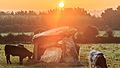
Ballynageeragh Portal Tomb was built in the 4th millennium BC
-
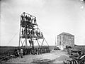
Mine workers at Bunmahon, County Waterford c. 1906

.jpg)
See also
 In Spanish: Condado de Waterford para niños
