
County Waterford facts for kids
Quick facts for kids
County Waterford
Contae Phort Láirge
|
||
|---|---|---|
|
||
| Nickname(s):
The Déise
|
||
| Motto(s):
Déisi oc Declán co Bráth (Old Irish)
"May the Déise remain with Declan forever" |
||
 |
||
| Country | Ireland | |
| Province | Munster | |
| Region | Southern | |
| Established | 1207 | |
| County town | Waterford | |
| Area | ||
| • Total | 1,858 km2 (717 sq mi) | |
| Area rank | 20th | |
| Highest elevation | 792 m (2,598 ft) | |
| Population | ||
| • Total | 127,363 | |
| • Rank | 20th | |
| • Density | 68.548/km2 (177.54/sq mi) | |
| Time zone | UTC±0 (WET) | |
| • Summer (DST) | UTC+1 (IST) | |
| Eircode routing keys |
E32, E91, X35, X42, X91 (primarily)
|
|
| Telephone area codes | 051, 058 (primarily) | |
| Vehicle index mark code |
W (since 2014) WD (1987–2013) |
|

County Waterford (Irish: Contae Phort Láirge) is a county in Ireland. It is located in the province of Munster, which is in the southern part of the country. The county is named after the city of Waterford.
The local government for the area is the Waterford City and County Council. In 2022, the total population of County Waterford, including the city, was 127,363 people. The county gets its nickname, "The Déise," from an ancient Irish tribe called the Déisi. There is also a special area in the southwest of the county where Irish is still spoken every day, called Gaeltacht na nDéise.
Contents
Exploring Waterford's Landscape
County Waterford is known for its beautiful natural features. It has two main mountain ranges: the Knockmealdown Mountains and the Comeragh Mountains. The highest point in the county is Knockmealdown, which stands at 794 meters high.
The county also has several important rivers. The River Suir is Ireland's third-longest river, stretching 184 kilometers. The Munster Blackwater is the fourth-longest, at 168 kilometers.
Waterford's Coastal Beauty
Waterford's coastline is very special, with over 30 beaches. A large part of this coast is called the Copper Coast. It's a UNESCO Geopark, meaning it's a place of great geological importance. You can see amazing rock formations and learn about the Earth's history there.
Irish-Speaking Areas
To the west of Dungarvan is the Déise Gaeltacht. This is an area where the Irish language is still spoken daily by many people. It includes the regions of Ring, County Waterford and Old Parish.
County Town and Divisions
Waterford City is the main town and administrative center of the county. Before 2014, Dungarvan was the county town for the rural parts of Waterford.
Historically, the county was divided into eight smaller areas called baronies. These include Coshmore and Coshbride, Decies-within-Drum, Decies-without-Drum, Gaultiere, Glenahiry, Middlethird, Upperthird, and Waterford City.
Major Towns in County Waterford
Here are some of the largest towns in County Waterford, based on the 2022 census:
| Rank | Town | Population (2022 census) |
|---|---|---|
| 1 | Waterford | 60,079 |
| 2 | Tramore | 11,277 |
| 3 | Dungarvan | 10,081 |
| 4 | Portlaw | 1,881 |
| 5 | Dunmore East | 1,731 |
| 6 | Ballinroad | 1,389 |
| 7 | Lismore | 1,347 |
| 8 | Tallow | 1,022 |
A Glimpse into History

County Waterford is often called "The Déise" (pronounced "day-shah"). This name comes from an ancient Irish tribe called the Déisi. They moved into the Waterford area between the 4th and 8th centuries and settled there. The area they ruled roughly matches the current Roman Catholic Diocese of Waterford and Lismore.
You can find many ancient sites in County Waterford, like huge stone tombs called megalithic tombs and stones with old Irish writing called ogham stones. The Ballynageeragh Portal Tomb, for example, was built thousands of years ago.
Viking and Norman Influence
The Vikings also left their mark on Waterford. Reginald's Tower in Waterford City is a famous example. It was one of the first buildings in Ireland to be made using bricks and mortar.
A Viking settlement from the 9th century was found near Waterford city, at a place called Woodstown. It was the biggest Viking settlement outside of Scandinavia at that time!
Later, the Anglo-Norman invasion of Ireland also brought new styles of buildings and changes to the area.
Gaeltacht na nDéise: The Irish Language Heartlands
Gaeltacht na nDéise is a special area in County Waterford where the Irish language is very much alive. It includes the parishes of An Rinn and An Sean Phobal.
This Gaeltacht area is about 10 kilometers from Dungarvan. In 2016, it had a population of 1,816 people and covered an area of 62 square kilometers. About 45.6% of the people living there spoke Irish every day.
| Historical population | ||
|---|---|---|
| Year | Pop. | ±% |
| 1600 | 14,456 | — |
| 1610 | 9,887 | −31.6% |
| 1653 | 13,136 | +32.9% |
| 1659 | 13,286 | +1.1% |
| 1821 | 76,103 | +472.8% |
| 1831 | 85,217 | +12.0% |
| 1841 | 196,187 | +130.2% |
| 1851 | 164,035 | −16.4% |
| 1861 | 134,252 | −18.2% |
| 1871 | 123,310 | −8.2% |
| 1881 | 112,768 | −8.5% |
| 1891 | 98,251 | −12.9% |
| 1901 | 87,187 | −11.3% |
| 1911 | 83,966 | −3.7% |
| 1926 | 78,562 | −6.4% |
| 1936 | 77,614 | −1.2% |
| 1946 | 76,108 | −1.9% |
| 1951 | 75,061 | −1.4% |
| 1956 | 74,031 | −1.4% |
| 1961 | 71,439 | −3.5% |
| 1966 | 73,080 | +2.3% |
| 1971 | 77,315 | +5.8% |
| 1979 | 87,278 | +12.9% |
| 1981 | 88,591 | +1.5% |
| 1986 | 91,151 | +2.9% |
| 1991 | 91,624 | +0.5% |
| 1996 | 94,680 | +3.3% |
| 2002 | 101,546 | +7.3% |
| 2006 | 107,961 | +6.3% |
| 2011 | 113,795 | +5.4% |
| 2016 | 116,176 | +2.1% |
| 2022 | 127,363 | +9.6% |
Images for kids
-
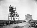
Mine workers at Bunmahon, County Waterford c. 1906
.jpg)
See also
 In Spanish: Condado de Waterford para niños
