
Counties of Ireland facts for kids
Quick facts for kids Counties of IrelandContaetha na hÉireann (Irish) |
|
|---|---|
| Location | Ireland (Republic of Ireland and Northern Ireland) |
| Found in | Provinces |
| Government | County councils (Republic of Ireland) |
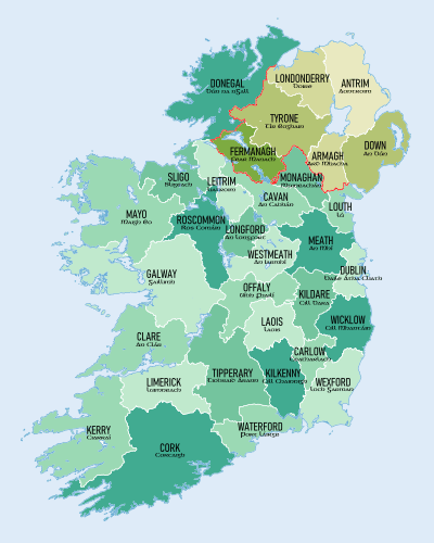
The counties of Ireland (Irish: Contaetha na hÉireann) are historic areas on the island. They were first created by the Normans. As time went on, these counties became very important for local control. Traditionally, there are 32 counties in Ireland.
When Ireland was divided in 1921, six of these traditional counties became part of Northern Ireland. In Northern Ireland, counties stopped being used for local government in 1973. Instead, they now use districts. In the Republic of Ireland, some counties have been split to create new ones. Today, there are 26 counties, 3 cities, and 2 cities and counties that manage local government.
Contents
What Does "County" Mean?
The word "county" can mean different things. Most often, it refers to the 32 traditional counties that existed before 1838. Twenty-six of these are in the Republic of Ireland. However, laws define counties to also include newer areas, like those in Dublin.
In Ireland, the word county usually comes before the name, like "County Roscommon". This is different from places like the United States, where it might be "Roscommon County". The old names "King's County" and "Queen's County" are now County Offaly and County Laois. We often use the short form "Co." for "County", like "Co. Roscommon".
Sometimes, especially in Dublin, the word county is dropped. For example, people might just say "Fingal" instead of "County Fingal". Informally, the word county is often left out unless it's needed to tell the difference between a county and a town or city. For example, "Offaly" is common, but "County Antrim" helps distinguish it from Antrim town.
Some towns and cities used to have their own special status, like a county corporate. This meant they had the same powers as a county, separate from the county around them.
History of Irish Counties
The idea of dividing Ireland into areas goes back a long way, even before the Normans arrived.
Early Divisions of Ireland
From about the 6th century, Ireland was made up of many small kingdoms. The smallest unit was called a Irish: túath. This was an independent group of people led by a local king. There were about 150 such areas. Each local king reported to a bigger "over-king."
Above these were "kings of over-kings," who ruled larger areas. These larger areas were often called "fifths" or provinces. These were Ulster, Leinster, Connacht, Munster, and Meath. Later, these were called provinces, similar to Roman provinces. Over time, Leinster and Meath joined together, forming today's Leinster province.
The system of counties eventually replaced these older provincial divisions. Today, provinces are mostly used for sports, like in GAA games and rugby.
Norman Era: Lordship and Division
When Cambro-Norman knights arrived in 1169, the Anglo-Norman invasion of Ireland began. King Henry II of England followed in 1172.
Henry II divided the English-controlled parts of Ireland into large areas called "liberties" or "lordships." These were like special counties where the local lord had almost as much power as the king. This was because the English king didn't have strong direct control over Ireland. These large areas were given to powerful Norman lords.
These big lordships were later split into smaller "liberties." King John is often given credit for dividing Leinster and Munster into smaller counties. These early counties included Carlow, Dublin, Kildare, Kilkenny, Louth, Meath, Wexford, Waterford, Cork, Limerick, Kerry, and Tipperary.
The main official in these special areas was the seneschal. In areas directly controlled by the Crown, this role was held by a sheriff. The exact borders of these areas changed a lot, depending on how much control the English had. For example, Kildare once included parts of what are now Offaly, Laois, and Wicklow.
However, the Bruce Invasion in 1315 weakened English rule. The land controlled by the Crown shrank to just Dublin and parts of Meath, Louth, and Kildare. The county system couldn't expand much during this time.
The Earls of Ulster also divided their territory into counties. In 1333, the Earldom of Ulster had seven counties: Antrim, Blathewyc, Cragferus, Coulrath, del Art, Dun, and Twescard.
Counties Under the Crown
Over time, many of the original large lordships came under the direct control of the English Crown. For example, the lordship of Leinster was divided into five counties: Carlow, Kildare, Kilkenny, Leix, and Wexford. Meath was also divided, and parts eventually passed to the Crown. Ulster and Connaught also became part of the Crown's lands.
As these areas came under Crown control, the special "Counties of the Cross" (where the king's sheriff had power over church lands) became less common. Only Tipperary remained a special case for a long time.
Tudor Era: Expanding the County System
It wasn't until the Tudor kings and queens, especially Henry VIII (1509–47), that the Crown's control spread throughout Ireland again. Henry VIII declared himself King of Ireland in 1541. He aimed to organize Irish chiefs and their lands into districts, which became the modern counties. In 1543, Meath was split into Meath and Westmeath.
Under Mary I (1553–58) and Elizabeth I (1558–1603), most of the modern counties were formed.
- In 1556, Mary I created King's County (now Offaly) and Queen's County (now Laois) from conquered lands.
- Under Elizabeth I, the province of Connaught was divided into Galway, Mayo, Roscommon, and Sligo. In 1565, Leitrim was formed from part of Roscommon.
- In 1569, Clare was made a county and became part of Connaught.
- Attempts were made to create Wicklow from the lands of the Byrnes and O'Tooles, but it wasn't officially formed until 1606.
- Longford was created in 1583 from part of Westmeath and moved to Connaught.
The biggest change was in Ulster, which was mostly outside English control. Sir John Perrot began shiring Ulster in 1584. Before this, only Louth was a proper county there. Antrim and Down had also been recognized as counties. The new counties created were Armagh, Cavan, Coleraine, Donegal, Fermanagh, Monaghan, and Tyrone. Cavan was moved from Connaught to Ulster in 1584.
After the Nine Years' War ended in 1603 and Irish chiefs fled in 1607 (the Flight of the Earls), their lands were taken by the Crown. The county divisions made by Perrot were then used for the Plantation of Ulster, which started in 1609. This led to the official creation of these Ulster counties.
County Londonderry was formed in 1613 by combining County Coleraine with parts of Tyrone, Donegal, and Antrim. By 1616, almost all counties had their borders set.
Tipperary's Special Status
Tipperary was a special case. It remained a "palatine" county, meaning it had its own special officials and rules, until 1715. At that time, it became one single county like the others. Between 1838 and 2014, Tipperary was divided into two areas: North Tipperary and South Tipperary.
Smaller Divisions within Counties
Counties were further divided into smaller areas. These were called baronies, and then parishes. Parishes were made up of townlands. Many of these divisions followed older, pre-Norman boundaries. There are over 300 baronies and thousands of civil parishes. There are about sixty thousand townlands, which vary greatly in size.
Counties Corporate (City Counties)
Some towns and cities were given special status as "counties corporate." This meant they had the same powers as a county. Examples include Carrickfergus, Cork, Drogheda, Dublin, Galway, Kilkenny, Limerick, and Waterford.
Changes in County Management
Counties were first used for legal purposes. Later, in the 17th century, they started to take on government roles. Local wealthy landowners and merchants, called "grand juries," managed the counties. They were in charge of roads, bridges, and collecting taxes.
19th and 20th Century Changes
In 1836, the powers of grand juries were expanded. In 1898, a major change happened with the Local Government (Ireland) Act 1898. This law created elected county councils for 33 administrative counties. These councils took over the grand juries' powers.
The borders of many traditional counties changed in 1898. Tipperary was officially split into North Riding and South Riding. Cities like Belfast, Cork, Dublin, Limerick, Derry, and Waterford became county boroughs, with the same powers as administrative counties.
The Government of Ireland Act 1920 divided Ireland into Southern Ireland and Northern Ireland. The county and county borough borders were used to draw this line. Southern Ireland soon became the Irish Free State (now the Republic of Ireland).
Counties Today
In the Republic of Ireland
In the Republic of Ireland, the traditional counties are still generally used for local government, planning, and community development. They are managed by county councils. Some administrative borders have been changed to put towns entirely within one county.
When the Irish Free State was formed in 1922, there were 27 administrative counties (including North and South Tipperary) and 4 county boroughs (Dublin, Cork, Limerick, and Waterford).
- In 1985, Galway became a county borough.
- In 1994, County Dublin was split into three new administrative counties: Dún Laoghaire–Rathdown, Fingal, and South Dublin.
- The Local Government Act 2001 changed the names of county boroughs to "cities," giving them the same legal status as counties.
- In 2014, the cities of Limerick and Waterford merged with their counties to form new "cities and counties." Also, North Tipperary and South Tipperary were reunited to form County Tipperary again.
Now, the Republic of Ireland has 31 local government areas: 26 counties, 3 cities, and 2 cities and counties.
Education
Since 2013, Education and Training Boards (ETBs) manage education in the Republic of Ireland. There are 16 ETB areas, each covering one or more local government areas.
Elections
When possible, election areas for the Dáil (Irish parliament) follow county borders. This means larger counties like Dublin and Cork have several election areas. Smaller counties, like Carlow and Kilkenny, might be grouped together.
Each county, city, and city and county is divided into local electoral areas for electing local councillors.
In Northern Ireland
In Northern Ireland, a big change in 1973 replaced the six traditional counties and two county boroughs (Belfast and Derry) with 26 smaller districts. In 2015, these districts were merged again to form 11 new "super districts."
The six traditional counties are still used for some things, like car number plates and for the Lord Lieutenants. They are also widely recognized for sports and cultural groups.
Other Uses of Counties
Many non-government groups and cultural organizations also use the traditional 32 counties. For example, the Gaelic Athletic Association (GAA) organizes its sports activities based on these traditional counties.
List of Counties
The table below lists the 35 divisions, including the traditional counties and the three new ones in Dublin. In the Republic of Ireland, 24 counties still define local government areas. County Dublin is included, even though it was abolished as a single administrative area in 1994. In Northern Ireland, the counties listed no longer serve as local government areas.
The "Region" column shows the NUTS 2 statistical regions for the Republic of Ireland counties. The "County town" is the main administrative town for the county.
The cities of Cork, Dublin, and Galway are separate local government areas with the same legal status as counties, so they are not listed separately here. The former county boroughs of Londonderry and Belfast are also not shown separately.
| County | Native name (Irish) |
Ulster-Scots name(s) |
County town | Most populous city/town |
Province | Region | |
|---|---|---|---|---|---|---|---|
| Antrim | Aontroim (Contae Aontroma) |
Anthrim Antrìm Entrim |
Antrim (traditional), Ballymena(Council) | Belfast (part) | Ulster | UKN0: Northern Ireland | |
| Armagh | Ard Mhacha (Contae Ard Mhacha) |
Airmagh | Armagh | Craigavon | Ulster | UKN0: Northern Ireland | |
| Carlow | Ceatharlach (Contae Cheatharlach) |
Carlow | Leinster | IE06: Eastern and Midland | |||
| Cavan | An Cabhán (Contae an Chabháin) |
Cavan | Ulster | IE04: Northern and Western | |||
| Clare | An Clár (Contae an Chláir) |
Ennis | Munster | IE05: Southern | |||
| Cork | Corcaigh (Contae Chorcaí) |
Coark | Cork | Munster | IE05: Southern | ||
| Donegal | Dún na nGall (Contae Dhún na nGall) |
Dinnygal Dunnygal |
Lifford | Letterkenny | Ulster | IE04: Northern and Western | |
| Down | An Dún (Contae an Dúin) |
Doon Doun |
Downpatrick | Belfast (part) | Ulster | UKN0: Northern Ireland | |
| Dublin | Baile Átha Cliath (Contae Bhaile Átha Cliath) |
Dublin | Leinster | IE06: Eastern and Midland | |||
| Dún Laoghaire–Rathdown | Dún Laoghaire–Ráth an Dúin | Dún Laoghaire | Leinster | IE06: Eastern and Midland | |||
| Fingal | Fine Gall | Swords | Leinster | IE06: Eastern and Midland | |||
| South Dublin | Áth Cliath Theas | Tallaght | Leinster | IE06: Eastern and Midland | |||
| Fermanagh | Fear Manach (Contae Fhear Manach) |
Fermanay | Enniskillen | Ulster | UKN0: Northern Ireland | ||
| Galway | Gaillimh (Contae na Gaillimhe) |
Galway | Connacht | IE04: Northern and Western | |||
| Kerry | Ciarraí (Contae Chiarraí) |
Tralee | Munster | IE05: Southern | |||
| Kildare | Cill Dara (Contae Chill Dara) |
Naas | Leinster | IE06: Eastern and Midland | |||
| Kilkenny | Cill Chainnigh (Contae Chill Chainnigh) |
Kilkenny | Leinster | IE05: Southern | |||
| Laois | Laois (Contae Laoise) |
Portlaoise | Leinster | IE06: Eastern and Midland | |||
| Leitrim | Liatroim (Contae Liatroma) |
Carrick-on-Shannon | Connacht | IE04: Northern and Western | |||
| Limerick | Luimneach (Contae Luimnigh) |
Lïmerick | Limerick | Munster | IE05: Southern | ||
| Londonderry | Doire (Contae Dhoire) |
Lunnonderrie | Coleraine | Derry | Ulster | UKN0: Northern Ireland | |
| Longford | An Longfort (Contae an Longfoirt) |
Langfurd | Longford | Leinster | IE06: Eastern and Midland | ||
| Louth | Lú (Contae Lú) |
Dundalk | Drogheda | Leinster | IE06: Eastern and Midland | ||
| Mayo | Maigh Eo (Contae Mhaigh Eo) |
Castlebar | Connacht | IE04: Northern and Western | |||
| Meath | An Mhí (Contae na Mí) |
Navan | Leinster | IE06: Eastern and Midland | |||
| Monaghan | Muineachán (Contae Mhuineacháin) |
Ronelann | Monaghan | Ulster | IE04: Northern and Western | ||
| Offaly | Uíbh Fhailí (Contae Uíbh Fhailí) |
Tullamore | Leinster | IE06: Eastern and Midland | |||
| Roscommon | Ros Comáin (Contae Ros Comáin) |
Roscommon | Connacht | IE04: Northern and Western | |||
| Sligo | Sligeach (Contae Shligigh) |
Sligo | Connacht | IE04: Northern and Western | |||
| Tipperary | Tiobraid Árann (Contae Thiobraid Árann) |
Nenagh | Clonmel | Munster | IE05: Southern | ||
| Tyrone | Tír Eoghain (Contae Thír Eoghain) |
Owenslann | Omagh | Ulster | UKN0: Northern Ireland | ||
| Waterford | Port Láirge (Contae Phort Láirge) |
Wattèrford | Waterford | Munster | IE05: Southern | ||
| Westmeath | An Iarmhí (Contae na hIarmhí) |
Mullingar | Athlone | Leinster | IE06: Eastern and Midland | ||
| Wexford | Loch Garman (Contae Loch Garman) |
Wexford | Leinster | IE05: Southern | |||
| Wicklow | Cill Mhantáin (Contae Chill Mhantáin) |
Wicklow | Bray | Leinster | IE06: Eastern and Midland | ||
Images for kids
-
Extent of Norman control in Ireland by 1300
-
The Pale (grey), earldoms and lordships (blue) in 1450


See also
 In Spanish: Condados de Irlanda para niños
