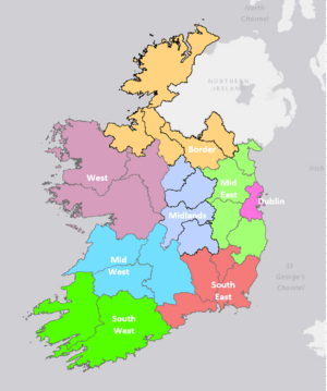
NUTS statistical regions of Ireland facts for kids
Ireland uses a special system called the Nomenclature of Territorial Units for Statistics (NUTS). This system helps to divide the country into different areas for collecting information and statistics. It's like giving each part of Ireland a unique code. The European Union created and manages this system.
The NUTS system is very important because it helps decide where money from the EU should go. This money, called European Structural and Investment Funds, helps different areas grow and develop. Ireland's NUTS code is IE. There are three main levels of these areas, set up by an organization called Eurostat. Even smaller areas, called Local Administrative Units (LAU), are known as local electoral areas in Ireland.
Contents
How Ireland is Divided
Ireland is split into different NUTS areas. Here's how many areas there are at each level:
| Level | Number of Areas |
|---|---|
| NUTS 1 | 1 |
| NUTS 2 statistical regions | 3 |
| NUTS 3 statistical regions | 8 |
| Local administrative units | 166 |
NUTS Levels: 1, 2, and 3
The NUTS areas were last updated in 2018. How regions get money from the European Regional Development Fund and the European Social Fund Plus was looked at again in 2021. NUTS 2 Regions can be grouped into three types: less developed, transition, or more developed. This helps the EU decide how much support each area needs.
Here is a breakdown of Ireland's NUTS regions:
| NUTS 1 | Code | NUTS 2 | Code | Status | NUTS 3 | Code | Local Government Areas |
|---|---|---|---|---|---|---|---|
| Éire / Ireland | IE0 | Northern and Western Region | IE04 | Transition | Border | IE041 | Cavan, Donegal, Leitrim, Monaghan, Sligo |
| West | IE042 | Mayo, Roscommon, Galway and Galway City | |||||
| Southern Region | IE05 | More developed | Mid-West | IE051 | Clare, Tipperary, Limerick City and County | ||
| South-East | IE052 | Carlow, Kilkenny, Wexford, Waterford City and County | |||||
| South-West | IE053 | Kerry, Cork and Cork City | |||||
| Eastern and Midland Region | IE06 | More developed | Dublin | IE061 | Dublin City, Dún Laoghaire–Rathdown, Fingal and South Dublin | ||
| Mid-East | IE062 | Kildare, Meath, Wicklow, Louth | |||||
| Midland | IE063 | Laois, Longford, Offaly, Westmeath |
Population and Area by NUTS 3 Region
This table shows how many people live in each NUTS 3 region, how big the area is, and how many people live per square kilometer. The population numbers are from the 2022 census.
| Region | Population (2022) | Area (km2) | Population Density | % of Ireland's Population |
|---|---|---|---|---|
| Border | 417,260 | 11,516 | 36 | 8.14% |
| West | 483,677 | 14,289 | 34 | 9.44% |
| Mid-West | 500,524 | 10,511 | 48 | 9.77% |
| South-East | 456,228 | 7,198 | 63 | 8.9% |
| South-West | 736,489 | 12,312 | 60 | 14.37% |
| Dublin | 1,450,701 | 926 | 1,567 | 28.31% |
| Mid-East | 761,858 | 6,891 | 111 | 14.87% |
| Midland | 316,799 | 6,651 | 48 | 6.18% |
| Ireland | 5,123,536 | 70,294 | 73 | 100% |
Local Administrative Units
In Ireland, the smallest administrative units are called local electoral areas. These are the areas used for local elections. Outside of Dublin, and in cities and counties, these areas also help form the municipal districts within local governments.
Regional Assemblies
Each of Ireland's three NUTS 2 regions has a Regional Assembly. These assemblies divide their areas into strategic planning zones, which match the NUTS 3 regions. Before 2014, the eight NUTS 3 regions had their own Regional Authorities. However, a law in 2014 got rid of these and gave their jobs to the new Regional Assemblies. The people who are part of these assemblies are chosen by local councils from their elected members.
 | Selma Burke |
 | Pauline Powell Burns |
 | Frederick J. Brown |
 | Robert Blackburn |


