
County Carlow facts for kids
Quick facts for kids
County Carlow
Contae Cheatharlach
|
||
|---|---|---|
|
||
| Nickname(s):
The Dolmen County
|
||
| Anthem: "Follow Me up to Carlow" | ||
 |
||
| Country | Ireland | |
| Province | Leinster | |
| Established | 1210 | |
| County town | Carlow | |
| Government | ||
| • Type | County Council | |
| Area | ||
| • Total | 897 km2 (346 sq mi) | |
| Area rank | 31st | |
| Highest elevation | 794 m (2,605 ft) | |
| Population
(2016)
|
||
| • Total | 56,932 | |
| • Rank | 30th | |
| • Density | 63.47/km2 (164.38/sq mi) | |
| Demonym(s) | Carlovian | |
| Time zone | UTC±0 (WET) | |
| • Summer (DST) | UTC+1 (IST) | |
| Eircode routing keys |
R21, R93 (primarily)
|
|
| Telephone area codes | 059 (primarily) | |
| Vehicle index mark code |
CW | |

County Carlow (KAR-loh; Irish: Contae Cheatharlach) is a county in the South-East Region of Ireland. It is part of the province of Leinster. Carlow is one of Ireland's smallest counties. It is the second smallest in size and the third least populated out of 32 traditional counties. The Carlow County Council is the local government here.
The county gets its name from the town of Carlow. This town is on the River Barrow. It is both the main town and the largest place to live in the county. More than 40% of the county's people live there. Many other people live in towns along the Barrow valley. These include Leighlinbridge, Muine Bheag, Tinnahinch, Borris, and St Mullins. Carlow borders Kildare and Laois to the north. It also borders Kilkenny to the west, Wicklow to the east, and Wexford to the southeast.
Carlow is often called "The Dolmen County." This name comes from the Brownshill Dolmen. It is a 6,000-year-old stone structure. It is said to have the heaviest capstone in Europe, weighing over 100 tonnes. The town of Carlow was started by the Normans in 1207. The county was officially formed soon after, making it one of Ireland's oldest counties. In the 1300s, Carlow was a very important place. It was the center of power for the Kingdom of Leinster. It was also the capital of the Lordship of Ireland from 1361 to 1374.
Contents
Exploring County Carlow's Geography
Carlow, or "Ceatharlach," was once part of the Norman Palantine-county of Leinster. It became a separate county around 1306. Back then, it was bigger than it is today. It even included the coastal area near Arklow. However, control of this area was argued over with Irish leaders. These areas were given to County Wicklow in 1606-07.
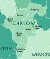
What are Baronies in Carlow?
There are seven historic baronies in County Carlow. Baronies are like old divisions of land. They are Carlow, Forth, Idrone East, Idrone West, Rathvilly, St Mullin's Lower, and St Mullin's Upper.
Towns and Villages of Carlow
Famous People from Carlow
Many interesting people have come from County Carlow:
- Pierce Butler – An important soldier and leader in the United States. He helped create the country.
- Myles Keogh – An army officer who fought in the American Civil War and American Indian Wars. He was killed at the Battle of the Little Bighorn.
- William Dargan – An engineer known as the father of Irish railways.
- Richie Kavanagh – A funny songwriter from Fenagh, Co. Carlow.
- John Tyndall – A scientist from the 1800s. He was the first to explain why the sky is blue.
- Derek Ryan – A country music singer. He was also in the pop band D-side.
- Saoirse Ronan – A famous actress nominated for Oscars and Golden Globes.
- Kathryn Thomas – An RTÉ television presenter.
- Peter Murphy – A radio and TV presenter for RTÉ. He was born in Carlow.
- Sean O'Brien – A rugby player for Leinster and Ireland.
- Frank O'Meara – An Irish artist from Carlow. He was known for his Impressionist landscape paintings.
- David Mullins – An Irish jockey. He won the 2016 Grand National race.
- Mary O'Toole – The first woman municipal judge in the United States.
Carlow's Economy: How People Make a Living
Carlow's economy is strong, even though it's a small county. In 2017, people in Carlow earned about €1.48 billion in total. They also paid a lot in taxes, showing that the county's businesses are doing well. People in Carlow also had a good amount of money to spend. The main jobs in Carlow are in shops, services, making things, medicine, and food and drink.
Farming in Carlow


Carlow has a big farming industry. It produces a lot of dairy products, grains, and vegetables. Carlow has always been known for its good farm products. In 1837, a book said that Carlow's farming was "highly improved." It also said that "wheat of a superior quality is grown" and that Carlow's barley was "celebrated and in great demand."
Making dairy products is the most profitable part of farming in Carlow. This has been true for a long time. In 2018, there were over 102,000 cows in the county. About 60% were beef cattle, and the rest were dairy cattle. Carlow also has many sheep and pigs.
There are over 1,800 farms in the county. They cover about 79% of the land. A good portion of this land is used for growing crops. Another part is for growing fruits and vegetables. The average farm in Carlow is bigger than the national average. In 2016, the total value of farm products from Carlow was €188 million.
Industries and Jobs in Carlow

In the past, Carlow was the main place in Ireland for making sugar beet. The Irish Sugar Manufacturing Company started in 1926. This was a big step for Ireland's industries. In 1933, the government took over the factory. They saw sugar making as a key national industry. The factory closed in 2005, which was a big event.
Today, Carlow's main industries are making things, biosciences, retail, services, and farming-related businesses. Burnside Group is the biggest employer, with over 800 workers. Autolaunch, a manufacturing company, employs 300 people. The medicine company Merck Sharp & Dohme has a vaccine factory in Carlow, employing 300 people. Glanbia agribusiness has two feed mills in the county.
In the services and IT sector, the US insurance company Unum employs 150 people in Carlow town. Netwatch, a security company from Carlow, employs 160 people locally. They also have many employees in the UK and USA.
Tullow Oil, a big oil and gas company, was started in Tullow in 1985. Even though its main office is now in London, it began right here in Carlow.
Who Lives in County Carlow?
| Main immigrant groups, 2016 | |
| Nationality | Population |
|---|---|
| 2,591 | |
| 2,119 | |
| 448 | |
| 304 | |
| 231 | |
| 158 | |
| 155 | |
| 144 | |
| 125 | |
| *Includes Hong Kong SAR | |
| Historical population | ||
|---|---|---|
| Year | Pop. | ±% |
| 1653 | 4,969 | — |
| 1659 | 5,434 | +9.4% |
| 1821 | 78,952 | +1352.9% |
| 1831 | 81,988 | +3.8% |
| 1841 | 86,228 | +5.2% |
| 1851 | 68,078 | −21.0% |
| 1861 | 57,137 | −16.1% |
| 1871 | 51,650 | −9.6% |
| 1881 | 46,568 | −9.8% |
| 1891 | 40,936 | −12.1% |
| 1901 | 37,748 | −7.8% |
| 1911 | 36,252 | −4.0% |
| 1926 | 34,476 | −4.9% |
| 1936 | 34,452 | −0.1% |
| 1946 | 34,081 | −1.1% |
| 1951 | 34,162 | +0.2% |
| 1956 | 33,888 | −0.8% |
| 1961 | 33,342 | −1.6% |
| 1966 | 33,593 | +0.8% |
| 1971 | 34,237 | +1.9% |
| 1979 | 38,668 | +12.9% |
| 1981 | 39,820 | +3.0% |
| 1986 | 40,988 | +2.9% |
| 1991 | 40,942 | −0.1% |
| 1996 | 41,616 | +1.6% |
| 2002 | 46,014 | +10.6% |
| 2006 | 50,349 | +9.4% |
| 2011 | 54,612 | +8.5% |
| 2016 | 56,932 | +4.2% |
In 2016, Carlow had 56,932 people living there. This was an increase of over 2,300 people since 2011. More people moved into the county than moved out. Many people also moved to Carlow from other parts of Ireland.
In 2016, most people in Carlow were White (94.3%). This included White Irish and other White backgrounds. There were also people of Asian (1.3%) and Black (1.0%) backgrounds. The biggest groups of people from other countries were British, Polish, Latvian, Romanian, and Lithuanian.
About 7.2% of Carlow's population was under 5 years old in 2016. About 21.6% were between 5 and 19. Most people (58.2%) were between 20 and 65. About 13.0% were over 65. The population was almost equally split between females and males.
Religion in Carlow
| Religion in Carlow – 2016 | ||||
|---|---|---|---|---|
| Religion | Percent | |||
| Roman Catholic | 82.5% | |||
| Other Christian | 6.9% | |||
| Muslim | 1.0% | |||
| Other Stated Religions | 0.8% | |||
| None or Not Stated | 8.8% | |||

Most people in Carlow identify with a religion (91.3%). About 6.9% said they had no religion. Christianity is the largest religious group, making up 89.4% of the population. Islam is the only other major religion, with 587 followers.
The largest Christian group is the Roman Catholic Church, with almost 47,000 members. The Church of Ireland is the next largest. Other Christian groups include Presbyterian and Pentecostal churches. Orthodox Christianity also has followers.
The Cathedral of the Assumption in Carlow is an important Catholic church. St Laserian's Cathedral in Old Leighlin is a 12th-century Church of Ireland cathedral. There is also a Presbyterian church and an Islamic Cultural Centre in Carlow town.
More people are saying they have no religion. This number grew a lot between 2011 and 2016. Now, 6.9% of the county's population has no religion.
Main Towns and Cities in Carlow
Carlow town is the county town and the biggest place to live. Over 40% of the county's people live there. It is the 13th largest urban area in Ireland.
|
Largest cities or towns in Carlow (Census 2016)
Source: |
||
|---|---|---|
| Rank | Pop. | |
| 1 | Carlow | 24,272 |
| 2 | Tullow | 4,673 |
| 3 | Muine Bheag | 2,837 |
| 4 | Rathvilly | 944 |
| 5 | Leighlinbridge | 914 |
| 6 | Ballon | 712 |
| 7 | Borris | 652 |
| 8 | Hacketstown | 597 |
| 9 | Carrickduff | 554 |
| 10 | Ballinabranna | 466 |
The Central Statistics Office (CSO) says an "Urban Area" is a town with over 1,500 people. Carlow only has three towns that are "urban areas." But most people in the county (55.8%) live in these larger towns. The rest live in rural areas. Almost two-thirds (64.3%) of Carlow's population live in the ten biggest settlements.
Sports and Games in Carlow
Gaelic Games (GAA)

In GAA, Carlow is known as a "dual county." This means that Gaelic football and Hurling are both very popular. The county competes in national leagues for both sports. Historically, Carlow hasn't won many top-level championships. Their biggest win was a Leinster football championship in 1944.
At the club level, Carlow teams have had more success. Football clubs play in the Carlow Senior Football Championship every year. The most successful club is Éire Óg, with 28 titles. Carlow clubs have won 6 Leinster Senior Club Football Championship titles. Éire Óg won 5 of these. No Carlow team has ever won the All-Ireland Senior Club Football Championship.
Hurling in Carlow is a more recent tradition. The first Carlow Senior Hurling Championship was in 1927. The most successful hurling club is St. Mullin's, with 27 titles. In 2013, Mount Leinster Rangers became the first Carlow club to win a Leinster Senior Club Hurling Championship title. They even reached the All-Ireland final the next year.
Other Popular Sports

Besides Gaelic games, other sports clubs started in Carlow in the late 1800s. The Phoenix Cricket Club (Ireland's oldest cricket club) was formed with help from Carlow landowners. The Carlow Cricket Club started the next year. The Bagnelstown Cricket Club began in 1843. This makes the games between these two clubs the longest cricket rivalry in Ireland.
The Carlow Rugby Football Club (Ireland's second oldest rugby club) was also started in 1873. A Polo club was also formed.
In soccer, Carlow had a team called F.C. Carlow in the League of Ireland. It stopped playing in 2016. Now, local amateur clubs play in the Carlow and District Football League. There are also over a dozen golf courses in the county.
| Club | Sport | League |
|---|---|---|
| County Carlow Football Club | Rugby union | Leinster League |
| IT Carlow Basketball | Basketball | NBCC League |
| Carlow Cricket Club | Cricket | Leinster Cricket Union |
| Carlow Hockey Club | Field hockey | Leinster Hockey Association |
| St Laurence O'Toole AC | Athletics | National Championships |
| Carlow Lawn Tennis Club | Tennis, Badminton, Squash |
|
Getting Around Carlow: Transport and Roads


Roads in County Carlow
County Carlow is on the main motorway from Dublin to Waterford, called the M9. The M9 goes around Carlow town. This has helped other towns near the motorway grow. The N80 crosses the county for about 33 km (20 miles). It runs from Carlow town to the Wexford border. The N81 follows an old railway line. It goes through the county for about 22 km (14 miles).
Bus Éireann and other private bus companies offer bus services to towns and villages.
Here are the main roads in County Carlow:
| Major roads in County Carlow | ||||
|---|---|---|---|---|
| Road Name | Description | Length | ||
| Dublin – Carlow – Kilkenny – Waterford | 119.01 km (73.95 mi) | |||
| Tullamore – Portlaoise – Carlow – Enniscorthy | 114.7 km (71.3 mi) | |||
| Tallaght – Blessington – Baltinglass – Rathvilly – Tullow | 76.8 km (47.7 mi) | |||
Train Travel in Carlow

There isn't much train service in Carlow. Only one train line is currently active. This line serves Carlow town and Muine Bheag. It is part of the main Dublin–Waterford railway line. Irish Rail operates this line. It runs eight trains a day (Monday to Friday) from Carlow to Heuston Station in Dublin. Many people use it to travel to Dublin for work or school.
In the past, there were more train lines. One line went from Naas to Tullow and Rathvilly. It opened in 1886. This line closed for passengers in 1947 and completely in 1959. Another line connected Carlow to Wexford. It opened in 1858 but closed in 1963.
Air Travel Options
For international flights, Dublin Airport is the closest airport to Carlow. It's less than a 2-hour drive from most places in the county. You can also get to Dublin Airport by bus from larger towns. Or you can take the train from Carlow town or Muine Bheag and then a special bus (Aircoach) in Dublin city. Waterford Airport is closer, but it is not currently operating flights.
Carlow has two small airstrips for light planes and fun flying. The Hacketstown Airfield is near Hacketstown. It has one runway. The Killamaster Airstrip is northwest of Carlow town.
Images for kids
-
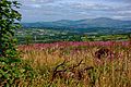
The rolling hills of central Carlow.
-
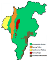
The natural regions of County Carlow.
-
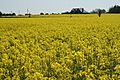
Flat plains are common in northern Carlow.
-
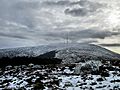
The top of Mount Leinster covered in snow.
-
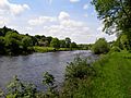
The River Barrow south of Borris.
-
A map showing the Baronies of County Carlow.
-
Art MacMurrough-Kavanagh, a King of Leinster.
-
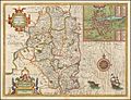
An early 1600s map. It shows Carlow reaching the Irish Sea.
-
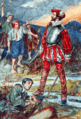
Sir Edmund Butler led a revolt in 1569.
-
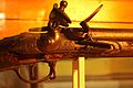
A Brown Bess musket used in the 1798 Rebellion. It is on display in the County Carlow Military Museum.
-
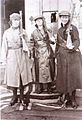
Cumann na mBan members at Duckett's Grove, 1921.
-
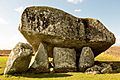
The Brownshill Dolmen, built around 4,000 BC.
-
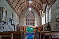
The 12th-century St Laserian's Cathedral.
-
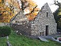
The 7th-century Monastic Site at St. Mullin's.
-
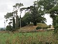
A 5th-century Motte in Rathvilly.
-
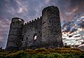
Carlow Castle, built in 1213. It was the first Norman castle of its kind in Britain or Ireland.
-
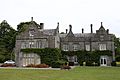
Huntington Castle, built in 1625. It's an early example of a plantation home.
-
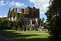
The 19th-century Lisnavagh House.
-
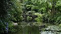
Altamont Gardens.
-
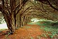
A Yew grove at Clonegal, planted in the early 1600s.
-
The Carlow Gaelic games flag.
-
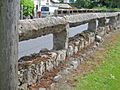
A "Carlow Fence."
-
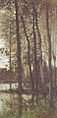
Autumnal greys (1880) by Frank O'Meara.


.jpg)


See also
 In Spanish: Condado de Carlow para niños
