
Carlow facts for kids
Quick facts for kids
Carlow
Ceatharlach
|
||
|---|---|---|
|
Town
|
||
|
|
||
|
||

Carlow
Location in Ireland

Carlow
Location in Europe
|
||
| Country | Ireland | |
| Province | Leinster | |
| County | County Carlow | |
| Government | ||
| • Type | Carlow Municipal District | |
| Area | ||
| • Total | 11.8 km2 (4.6 sq mi) | |
| Elevation | 57 m (187 ft) | |
| Population
(2022)
|
||
| • Total | 27,351 | |
| • Rank | 12th | |
| • Density | 2,318/km2 (6,003/sq mi) | |
| Time zone | UTC±0 (WET) | |
| • Summer (DST) | UTC+1 (IST) | |
| Eircode routing key |
R93
|
|
| Telephone area code | +353(0)59 | |
| Irish Grid Reference | S724771 | |


Carlow (pronounced KAR-loh) is a lively town in the south-east of Ireland. It is the main town of County Carlow and is about 84 kilometers (52 miles) from Dublin. In 2022, Carlow had a population of 27,351 people, making it the twelfth-largest urban area in Ireland.
The River Barrow flows right through Carlow. This river used to be the old border between County Laois and County Carlow. However, since 1898, the whole town has been part of County Carlow. Carlow is a very old settlement, dating back thousands of years. It even served as the capital of Ireland for a short time in the 14th century!

Contents
- What's in a Name? The Meaning of Carlow
- Carlow's Past: A Journey Through History
- The Irish Language in Carlow
- Media in Carlow
- Places to Visit in Carlow
- Carlow's Economy
- Getting Around Carlow
- Education in Carlow
- Religion in Carlow
- Sports in Carlow
- Carlow's Climate
- Famous People from Carlow
- Twin Towns
- Images for kids
- See also
What's in a Name? The Meaning of Carlow
The name Carlow comes from the Irish language word Ceatharlach. It was spelled in different ways in the past, like Caherlagh or Caterlagh.
Most people believe the name comes from an old Irish word, cethrae, which means "animals" or "cattle". The second part, -lach, is a common ending that makes words into groups. So, Ceatharlach might mean "place of animals" or "where many animals are found."
Some people thought the name meant "four lakes" (Ceatharloch), but there is no proof that four lakes ever existed in the area.
Carlow's Past: A Journey Through History
| Historical population | ||
|---|---|---|
| Year | Pop. | ±% |
| 1813 | 6,146 | — |
| 1821 | 8,035 | +30.7% |
| 1831 | 9,114 | +13.4% |
| 1841 | 10,409 | +14.2% |
| 1851 | 8,690 | −16.5% |
| 1861 | 8,344 | −4.0% |
| 1871 | 7,842 | −6.0% |
| 1881 | 7,185 | −8.4% |
| 1891 | 6,619 | −7.9% |
| 1901 | 6,513 | −1.6% |
| 1911 | 6,619 | +1.6% |
| 1926 | 7,163 | +8.2% |
| 1936 | 7,649 | +6.8% |
| 1946 | 7,466 | −2.4% |
| 1951 | 7,667 | +2.7% |
| 1956 | 8,445 | +10.1% |
| 1961 | 8,920 | +5.6% |
| 1966 | 9,765 | +9.5% |
| 1971 | 10,399 | +6.5% |
| 1981 | 13,164 | +26.6% |
| 1986 | 13,816 | +5.0% |
| 1991 | 14,027 | +1.5% |
| 1996 | 14,979 | +6.8% |
| 2002 | 18,487 | +23.4% |
| 2006 | 20,724 | +12.1% |
| 2011 | 23,030 | +11.1% |
| 2016 | 24,272 | +5.4% |
| 2022 | 27,351 | +12.7% |
People have lived in the Carlow area for thousands of years. A very old and impressive site is the Brownshill Dolmen. This is a huge stone tomb just outside Carlow town.
Early Settlements and Monasteries
Many early Christian settlements were built around the county. St Mullin's monastery was likely founded around the 7th century. Its ruins can still be seen today. Old Leighlin was once one of Ireland's biggest monastic settlements. A church meeting in 630 AD decided the date of Easter there. St Comhgall also built a monastery in Carlow in the 6th century. An old church and burial ground from that time are still at Castle Hill, known as Mary's Abbey.
Carlow Castle and Its Role
Carlow Castle was built by William Marshal between 1207 and 1213. Its purpose was to protect the important river crossing. It also served as the capital of the Lordship of Ireland from 1361 to 1374. Most of this grand castle was destroyed in 1814. This happened when someone tried to turn it into a hospital for people with mental health issues. Today, you can still see the West Wall and two of its round towers.
Growth of the Town
Carlow officially became a borough (a town with its own government) in 1296. The bridge over the River Barrow, called Graiguecullen Bridge, was built in 1569. It was later made wider in 1815 and renamed Wellington Bridge. This was to celebrate the Duke of Wellington's victory over Napoleon Bonaparte at the Battle of Waterloo. A house was built on the bridge in the 19th century. It was once home to the Poor Clares, a religious group.
The old Presentation Order convent now holds the County Library and the Carlow County Museum. Carlow Cathedral, designed by Thomas Cobden, was the first Catholic cathedral built in Ireland after Catholics gained more rights in 1829. It cost £9,000 and was finished in 1833.
Saint Patrick's College, next to the cathedral, started in 1793. It taught different subjects to both regular students and those studying to become priests. The Carlow Courthouse was built in the 19th century. Many old estates and houses, like Ducketts Grove, are still in the surrounding areas.
Transport and Industry
In 1703, a plan began to make the River Barrow easier to travel on. By 1800, the River Barrow Track was finished. This connected Carlow to the Grand Canal, which goes between Dublin and the Shannon River. By 1845, 88,000 tons of goods were moved on the river!
Carlow was also one of the first towns to get a train connection. The Great Southern and Western Railway reached Carlow in 1846. The main engineer, William Dargan, was from Killeshin, near Carlow.
_(page_1_crop).jpg)
Electricity first came to Carlow in 1891 from Milford Mills, about 8 km south of the town. Milford Mills still makes electricity today. After Ireland became independent in the 1920s, a sugar factory was built in Carlow in 1926. It was chosen because of its good transport links and farming land for growing sugar beet. The factory closed in 2005.
Rebellions and Battles
Carlow is mentioned in the famous Irish folk song, Follow Me Up to Carlow. This song is about the Battle of Glenmalure in the late 16th century. In 1650, during the Cromwellian conquest of Ireland, English forces took over Carlow.
During the Irish Rebellion of 1798, Carlow was the site of a sad event called the Battle of Carlow. About 600 rebels and civilians were killed after an attack on the town by the United Irishmen. The Liberty Tree sculpture in Carlow, created by John Behan, remembers these events. The rebels are buried in the 'Croppies Grave' on '98 Street in Graiguecullen.
The Irish Language in Carlow
Until the early 1800s, the Irish language was spoken in all twelve counties of Leinster, including County Carlow. The Irish spoken in Carlow was part of a central dialect. It had special features that are now only found in the Irish spoken in Connacht.
Today, people are working to increase the use of Irish in Carlow through an organization called Glór Cheatharlach. Carlow has two schools where all subjects are taught through Irish: a primary school (Gaelscoil) started in 1982 and a secondary school (Gaelcholáiste) started in 1990. Both schools are very popular. There is also an Irish-speaking pre-school and an intensive summer course for students.
Media in Carlow
The Nationalist is a local newspaper that started in 1883. The Carlow People is another free weekly newspaper in the area.
Places to Visit in Carlow
Brownshill Dolmen
One of Carlow's most famous sights is the Brownshill Dolmen. It is located on the Hacketstown Road, about 5 km from the town center. The top stone of this dolmen is thought to be the largest in all of Europe!

Carlow Cathedral

Milford
Milford is a beautiful green area along the River Barrow, about 8 km outside Carlow town. It is known for Milford Mill, which was the first inland hydro-electrical plant in Ireland. It started providing power to Carlow town in 1891.
Other Interesting Places
The Oak Park estate is about 3 km north of Carlow. Carlow Town Hall was finished in March 1886.
Carlow's Economy
Carlow's industry has changed a lot over time. In the early 20th century, the town became important for Ireland's industrial growth with the Irish Sugar Company. This sugar factory opened in 1926. It was a very modern factory for its time. However, it closed on March 11, 2005, because it was no longer profitable to run.
Another big employer in Carlow was OralB Braun, which made hairdryers and electric toothbrushes. This factory closed in 2010. Burnside is another large company in the area that makes hydraulic cylinders. The South East Technological University also provides many jobs in the town.
Since opening in 2003, Fairgreen Shopping Centre has also created many jobs. Big stores like Tesco, Heatons, Next, New Look, and River Island are located there. Recently, the pharmaceutical company Merck & Co. has expanded its manufacturing campus in Carlow, creating over 500 jobs.
Getting Around Carlow
The N9 road from Dublin to Waterford used to go right through Carlow. But in May 2008, a bypass (part of the M9 motorway) was opened. This greatly reduced traffic in the town. The N80 national road also goes around the edge of the town. These transport links have helped Carlow grow as a town connected to Dublin.
The Institute of Technology, Carlow (now part of South East Technological University) has also helped the area grow. It encourages many students to stay in the town after school. Carlow railway station opened on August 4, 1846, and is still open for public travel today. Carlow also has a local bus service with two routes, CW1 and CW2, run by Bus Éireann.
Education in Carlow
Carlow has several secondary schools for students. These include Gaelcholáiste Cheatharlach (an Irish-speaking school), Tyndall College, Tullow Community School, St. Mary's Academy CBS, and St Leo's College. There is also the Carlow Institute of Further Education for students after secondary school.

For higher education, Carlow has the South East Technological University (formerly the Institute of Technology, Carlow) and Carlow College.
Religion in Carlow
Carlow Cathedral, dedicated to Our Lady of Assumption, was started in 1828 and finished in 1833. It was built in the Gothic style. Inside, there is a sculpture by John Hogan that was completed in 1839.

Sports in Carlow
Motor Racing History
On July 2, 1903, the Gordon Bennett Cup motor race passed through Carlow. This was the first international motor race held in Great Britain or Ireland. Ireland was chosen because racing was not allowed on public roads in Britain. As a compliment to Ireland, the British team raced in Shamrock green, which later became known as British racing green. The race was 328 miles (528 km) long and was won by Belgian racer Camille Jenatzy.
Racquetball
The Carlow Racquetball club was founded in 1978. It is one of the largest racquetball clubs in the southeastern region of Ireland.
Local Sports Clubs
Carlow has many sports clubs. Some of the GAA clubs in the area include Tinryland GAA Club, Éire Óg GAA Club, and O'Hanrahans GAA Club.
County Carlow Football Club is the local rugby union club. F.C. Carlow is a local association football (soccer) club. Carlow also has boxing clubs, an athletics club, a karate club, a golf club, a rowing club, a tennis club, and a hockey club. The Carlow Jaguar Scooter Club, started in 1979, is one of the oldest scooter clubs in Ireland or England.
Carlow's Climate
Carlow has a mild oceanic climate, which means it has cool winters and mild, humid summers. There are no extreme temperatures. The coldest month is February, with an average low of 2.1°C (35.8°F). The hottest month is July, with an average high of 21.3°C (70.3°F). The driest months are April and May, while November is the wettest. It rains fairly evenly throughout the year, and humidity is high.
| Climate data for Oak Park (3km north of Carlow), elevation: 61 m or 200 ft, 2004-2020 normals | |||||||||||||
|---|---|---|---|---|---|---|---|---|---|---|---|---|---|
| Month | Jan | Feb | Mar | Apr | May | Jun | Jul | Aug | Sep | Oct | Nov | Dec | Year |
| Mean daily maximum °C (°F) | 8.3 (46.9) |
8.6 (47.5) |
10.5 (50.9) |
13.3 (55.9) |
16.1 (61.0) |
19.0 (66.2) |
21.3 (70.3) |
20.7 (69.3) |
18.0 (64.4) |
14.3 (57.7) |
10.4 (50.7) |
8.5 (47.3) |
14.1 (57.3) |
| Mean daily minimum °C (°F) | 2.3 (36.1) |
2.1 (35.8) |
2.6 (36.7) |
4.4 (39.9) |
6.9 (44.4) |
9.6 (49.3) |
11.5 (52.7) |
11.2 (52.2) |
9.3 (48.7) |
7.0 (44.6) |
4.0 (39.2) |
2.5 (36.5) |
6.1 (43.0) |
| Average precipitation mm (inches) | 78.8 (3.10) |
64.8 (2.55) |
63.1 (2.48) |
45.4 (1.79) |
49.6 (1.95) |
63.3 (2.49) |
69.6 (2.74) |
79.2 (3.12) |
66.2 (2.61) |
89.9 (3.54) |
98.1 (3.86) |
95.4 (3.76) |
863.4 (33.99) |
| Average precipitation days (≥ 1 mm) | 13 | 12 | 11 | 9 | 11 | 9 | 11 | 10 | 9 | 12 | 12 | 13 | 132 |
| Source: Met Éireann | |||||||||||||
Famous People from Carlow
Many interesting people have connections to Carlow:
- Pádraig Amond (born 1988) – An Irish professional footballer.
- Yvonne Barr (1932–2016) – A scientist who helped discover the Epstein–Barr virus.
- John Gibbons – A record producer and DJ.
- Arthur MacMurrough Kavanagh (1831–1889) – A politician.
- John Lyons (1824–1867) – Received the Victoria Cross for bravery.
- Seán O'Brien (born 1987) – An Irish international rugby player.
- Saoirse Ronan (born 1994) – A famous actress.
- Kathryn Thomas (born 1979) – A television presenter for RTÉ.
- John Tyndall (1820–1893) – A well-known physicist.
Twin Towns
Carlow is "twinned" with other towns around the world. This means they have special friendly relationships and often share cultural exchanges. Carlow is twinned with:
 Davenport, Iowa, United States
- Tempe, Arizona, United States
 Dole, Jura, France
 Northwich, Cheshire, England
Images for kids
-
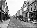
Dublin Street, Carlow circa 1900
.jpg)
See also
 In Spanish: Carlow para niños
