
Grand Canal (Ireland) facts for kids
Quick facts for kids Grand CanalAn Chanáil Mhór |
|
|---|---|

The Grand Canal in Dublin
|
|
| Specifications | |
| Length | 132 km (82 miles) |
| Locks | 43 |
| Status | Open |
| Navigation authority | Waterways Ireland |
| History | |
| Construction began | 1756 |
| Date completed | 1804 |
| Geography | |
| Start point | Shannon Harbour |
| End point | Grand Canal Dock |
| Connects to | River Shannon |
The Grand Canal (called An Chanáil Mhór in Irish) is a famous waterway in Ireland. It connects Dublin in the east with the River Shannon in the west. This canal passes through many towns and villages, including Tullamore. It is one of two canals that almost go all the way around Dublin's city centre. The other canal is the Royal Canal, which is on the north side of Dublin. The last boat carrying goods on the Grand Canal sailed in 1960.
Contents
Canal Branches and Routes

Canals often have smaller waterways that branch off them, like roads have side streets. The Grand Canal has several of these branches.
- The main route goes from Grand Canal Harbour in Dublin, near St. James's Gate, all the way to Shannon Harbour in County Offaly.
- A big part of the Dublin City section of the canal is now used by the Luas tram system. When this part was still used by boats, the canal from Crumlin to the Liffey in Ringsend Basin was seen as a separate branch. It was added later and was called the Circular Line.
- The Naas/Corbally branch is navigable to Naas. However, a low bridge stops boats from reaching Corbally.
- The Barrow branch connects the canal to the River Barrow at Athy.
- The Milltown feeder is a small channel that brings water into the canal.
- The Mountmellick Line used to leave the Barrow Line at Monasterevin and went through Portarlington. This line is no longer used.
- Other branches that are no longer used include the Blackwood feeder, the Lough Boora feeder, and the Kilbeggan branch.
- The Ballinasloe branch started on the other side of the River Shannon from Shannon Harbour. It is now used by a railway for industrial purposes.
History of the Grand Canal
People first thought about connecting Dublin to the Shannon River as early as 1715. In 1757, the Irish Parliament gave £20,000 to Thomas Omer to begin building the canal. By 1759, he had built about 3 kilometres (1.9 miles) of canal in the Bog of Allen. He also built 13 kilometres (8.1 miles) of canal from the River Liffey near Sallins towards Dublin.
By 1763, Omer had finished 3 locks and 6 bridges near Dublin. He was also working on getting water from the Morell River near Sallins to supply the canal. The Corporation of Dublin then realized the canal could help supply water to the city. They provided money to finish the canal into Dublin. However, when the canal was filled, its banks broke, and the city did not get its water. By 1768, £77,000 had been spent, and not much more money was available.
_Dublin_Society_and_the_Grand_Canal_Company,_Grafton_Street.jpg)
In 1772, a group of important people and business owners formed the Grand Canal Company. They wanted to make sure the canal would be completed. Their biggest challenge was crossing the Bog of Allen, a very soft and wet area. This was a new and difficult project for canal building. The company asked John Smeaton and his helper William Jessop to visit Ireland for two weeks to give advice.
Smeaton suggested building the canal around the bog at a high level. This was different from Omer's idea, which tried to drain parts of the bog and build at a lower level. Smeaton also advised making the locks smaller. Omer's locks were very large (42 metres by 6 metres), but Smeaton suggested 18 metres by 4 metres. This change would save a lot of money on the total cost of the canal.

The canal from Sallins finally opened for boats in 1779. A passenger boat service from Sallins to Dublin began in 1780, running twice a week. The canal was extended to Robertstown in 1784. This extension included the Leinster Aqueduct, a bridge that carries the canal over the Liffey River. Richard Evans built this aqueduct.
By 1791, the canal reached a connection with the River Barrow at Athy. The "Circle Line" through Dublin, from Portobello to Ringsend, started in 1790 and opened in 1796. Large docks were built near the Liffey in Ringsend. The company then focused on connecting the canal to the Shannon River.
Crossing the Bog of Allen was very difficult and took more than five years. Jessop tried to use clay walls to support the canal banks, but serious leaks happened. He had to stop using this method. The work to reach the Shannon then continued under John Killaly. He managed to cross another bog by draining it for several years before building. The canal was mostly finished in 1803. However, due to leaks and a dry summer, the official opening was delayed until April 1804. The canal took 47 years to build, moving forward about 7.7 metres (25 feet) each day.
The entire project cost around £877,000. It took several years for the canal to make a profit, even though shareholders received regular payments. The amount of goods transported increased from 100,000 tons in 1800 to 200,000 tons in 1810. Money earned from passenger boats also grew to £90,000 by that time. The long time it took to build the Grand Canal led to a competing project, the Royal Canal. Construction on the Royal Canal began in 1790 and it finally opened in 1817. The government had to step in to solve disagreements between the two canal companies.
In the 1960s, Dublin Corporation had plans to drain the canal. They wanted to replace it with a 6-lane road and lay new sewage pipes along the canal bed. Many people opposed these plans. A petition with 100,000 signatures was collected against the idea. Because of this strong opposition, the plans were eventually stopped.
The Canal's Route

The Grand Canal starts at Grand Canal Dock near the River Liffey. It then travels west towards the River Shannon. It goes through Ringsend and crosses the southside of Dublin. Along this path, it marks the northern edges of areas like Ballsbridge, Ranelagh, Rathmines, Harolds Cross, and Crumlin. This part of the canal is called the Circular Line or Circle Line and has seven locks.
The path of the original main line, which served the Grand Canal Harbour, the City Basin (a water reservoir), and the Guinness brewery, can still be seen at Rialto. Most of this old route now runs next to the Red Luas Line.
From Suir Road Bridge, the locks are numbered again starting at 1. The canal continues west through the suburbs of Dublin West and into Kildare. At Sallins, the Naas/Corbally branch turns south. The Grand Canal keeps going west, passing Caragh, Prosperous, and Robertstown. Robertstown is the highest point of the canal.
Just outside Sallins, the canal crosses over the River Liffey on the Leinster Aqueduct. East of Robertstown, the Blackwood Feeder used to join the canal. West of Robertstown is the busiest part of the canal, where the Old Barrow Line, Milltown Feeder, and the entrances to the Athy & Barrow Navigation meet. Further west, the canal goes through Edenderry, Tullamore, Rahan, and Pollagh. Finally, it reaches the Shannon River at Shannon Harbour in County Offaly. The main line of the canal is about 131 kilometres (81 miles) long and has 43 locks, with five of them being double locks.
Who Owns the Canal?

Until 1950, the Grand Canal Company owned the canal. Then, the Transport Act, 1950 transferred ownership of the canal to Córas Iompair Éireann, which is Ireland's public transport company. This continued until the Canals Act, 1986 gave it to the Office of Public Works, a government body.
In 1998, the Good Friday Agreement was signed. Because of this agreement, a new body called Waterways Ireland was created in 1999. This organization is responsible for most of the inland waterways in Ireland, including the Grand Canal.
Grand Canal Way: A Walking Trail
The Grand Canal Way (Bealach na Canálach Móire in Irish) is a long walking trail. It is about 117 kilometres (73 miles) long. The trail follows the towpath of the canal from Lucan Bridge, near Adamstown, all the way to Shannon Harbour. Most people take about five days to walk the entire trail.
The National Trails Office of the Irish Sports Council has named it a National Waymarked Trail. Waterways Ireland manages the trail. At Robertstown, the Grand Canal Way crosses paths with the Barrow Way. The Barrow Way follows part of the Barrow Line extension of the canal to Athy. There is also a shorter greenway, which is a path for walking and cycling, that is about 8.5 kilometres (5.3 miles) long. This greenway runs between the 3rd Lock at Inchicore and the 12th Lock at Lucan. It opened in June 2010.
Gallery
-
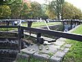
A lock on the Grand Canal in Dublin
-
Dublin's city bason (city basin), which received water from the Grand Canal through gates and sluices.

,_Dublin.jpg)
See also
 In Spanish: Gran Canal de Irlanda para niños
- List of bridges over the Grand Canal in Greater Dublin
- Canals of Ireland
- Rivers of Ireland
- Transport in Ireland
- Grand Canal Dock
