
County Kildare facts for kids
Quick facts for kids
County Kildare
Contae Chill Dara
|
||
|---|---|---|
|
||
| Nickname(s):
The Thoroughbred County
|
||
| Motto(s): | ||

Location of County Kildare (dark green) in Ireland
|
||
| Country | Ireland | |
| Province | Leinster | |
| Region | Eastern and Midland | |
| Established | 1297 | |
| County town | Naas | |
| Largest settlement | Naas | |
| Area | ||
| • Total | 1,695 km2 (654 sq mi) | |
| Area rank | 24th | |
| Highest elevation | 379 m (1,243 ft) | |
| Population
(2022)
|
||
| • Total | 246,977 | |
| • Rank | 7th | |
| • Density | 145.71/km2 (377.38/sq mi) | |
| Time zone | UTC±0 (WET) | |
| • Summer (DST) | UTC+1 (IST) | |
| Eircode routing keys |
R14, R45, R51, W12, W23, W34, W91 (primarily)
|
|
| Telephone area codes | 01, 045, 059 (primarily) | |
| Vehicle index mark code |
KE | |

County Kildare (called Contae Chill Dara in Irish) is a county in Ireland. It is located in the province of Leinster. Kildare is part of the Eastern and Midland Region. The county gets its name from the town of Kildare.
Kildare County Council is the local government for the area. In 2022, the county had a population of 246,977 people.
Contents
- Exploring County Kildare's Geography
- A Brief History of County Kildare
- People and Population in Kildare
- Getting Around: Transport in Kildare
- The Irish Language in Kildare
- Learning in Kildare: Education
- Sports and Fun in County Kildare
- Interesting Places to Visit
- Famous People from County Kildare
- Sister Cities and Twinning
- Images for kids
- See also
Exploring County Kildare's Geography
Kildare is the 24th largest county in Ireland by land area. It is the seventh largest in terms of how many people live there. Among the twelve counties in Leinster, Kildare is the eighth largest in size. It is the second largest in population.
Kildare shares borders with several other counties. These include Carlow, Laois, Meath, Offaly, South Dublin, and Wicklow. Since Kildare is an inland county, most of its land is low and flat. The highest parts are found in the foothills of the Wicklow Mountains to the east. The highest point in Kildare is Cupidstown Hill. It is located near the border with South Dublin. Another well-known spot is the Hill of Allen in the middle of Kildare.
Towns and Villages in Kildare
Many towns and villages make up County Kildare. Some of the main ones include:
- Allen
- Allenwood
- Ardclough
- Athy
- Ballitore
- Ballymore Eustace
- Calverstown
- Caragh
- Carbury
- Castledermot
- Celbridge
- Clane
- Coill Dubh
- Curragh
- Derrinturn
- Eadestown
- Johnstown
- Johnstownbridge
- Kilberry
- Kilcock
- Kilcullen
- Kildangan
- Kildare
- Kill
- Kilmead
- Kilmeage
- Kilteel
- Leixlip
- Lullymore
- Maynooth
- Milltown
- Monasterevin
- Moone
- Naas
- Narraghmore
- Newbridge
- Nurney
- Prosperous
- Rathangan
- Robertstown
- Sallins
- Staplestown
- Straffan
- Suncroft
- Timolin
- Two Mile House
Rivers, Canals, and Natural Areas

Kildare has three important rivers: the Barrow, the Liffey, and the Boyne. The Grand Canal also runs through the county. It stretches from Lyons in the east to Rathangan and Monasterevin in the west. A southern part of this canal connects to the Barrow river at Athy. The Royal Canal goes across the north of the county, along the border with Meath.
Pollardstown Fen is the largest remaining calcareous fen in Ireland. A fen is a type of wetland. This fen covers 220 hectares (about 540 acres). It is known as a very important fen ecosystem. It has unique and rare plant life. It became a National Nature Reserve in 1986.
The Bog of Allen is a huge bog that covers 958 square kilometers (370 square miles). It spreads into County Kildare and other nearby counties. Kildare has 243 square kilometers (94 square miles) of bogland. This is almost 14% of Kildare's land area. Most of this is a type called Raised Bog. This bog is home to over 185 different kinds of plants and animals.
Kildare also has 8,472 hectares (about 20,935 acres) of forested land. This makes up about 5% of the county's total area. A large part of these forests are owned by Coillte and Dúchas. Coillte manages Donadea Forest Park. This park is in North-Central Kildare. It covers 259 hectares (640 acres) of mixed woodland. It is the biggest forest park in Kildare.
| Historical population | ||
|---|---|---|
| Year | Pop. | ±% |
| 1500 | 2,887 | — |
| 1510 | 4,112 | +42.4% |
| 1550 | 5,033 | +22.4% |
| 1580 | 6,787 | +34.8% |
| 1585 | 3,454 | −49.1% |
| 1600 | 4,556 | +31.9% |
| 1610 | 8,714 | +91.3% |
| 1653 | 11,983 | +37.5% |
| 1659 | 13,825 | +15.4% |
| 1672 | 54,110 | +291.4% |
| 1788 | 71,570 | +32.3% |
| 1813 | 85,000 | +18.8% |
| 1821 | 99,065 | +16.5% |
| 1831 | 108,424 | +9.4% |
| 1841 | 114,488 | +5.6% |
| 1851 | 95,723 | −16.4% |
| 1861 | 90,946 | −5.0% |
| 1871 | 83,614 | −8.1% |
| 1881 | 75,804 | −9.3% |
| 1891 | 70,206 | −7.4% |
| 1901 | 63,566 | −9.5% |
| 1911 | 66,627 | +4.8% |
| 1926 | 58,028 | −12.9% |
| 1936 | 57,892 | −0.2% |
| 1946 | 64,849 | +12.0% |
| 1951 | 66,437 | +2.4% |
| 1956 | 65,915 | −0.8% |
| 1961 | 64,420 | −2.3% |
| 1966 | 66,404 | +3.1% |
| 1971 | 71,977 | +8.4% |
| 1979 | 97,185 | +35.0% |
| 1981 | 104,122 | +7.1% |
| 1986 | 116,247 | +11.6% |
| 1991 | 122,656 | +5.5% |
| 1996 | 134,992 | +10.1% |
| 2002 | 163,944 | +21.4% |
| 2006 | 186,335 | +13.7% |
| 2011 | 210,312 | +12.9% |
| 2016 | 222,504 | +5.8% |
| 2022 | 246,977 | +11.0% |
A Brief History of County Kildare
County Kildare was officially formed in 1297. Its current borders were set in 1832. This happened after some changes were made to include or remove certain areas.
The county was once home to the very powerful Fitzgerald family. Parts of Kildare were also part of an area called the Pale. This was a small region around Dublin that was controlled by the English.
People and Population in Kildare
The number of people living in County Kildare has grown a lot. From 1990 to 2005, the population almost doubled. In 2022, the county's population was 246,977.
The 2016 census (a count of the population) showed that most people in County Kildare are white Irish (84%). About 9% are from other white backgrounds. The census also recorded that 80% of the population were Catholic. About 9% followed other religions, and 10% said they had no religion.
Main Immigrant Groups in 2016
| Main immigrant groups, 2016 | |
| Nationality | Population |
|---|---|
| 10,527 | |
| 6,869 | |
| 1,550 | |
| 1,156 | |
| 1,120 | |
| 1,088 | |
| 1,082 | |
| 929 | |
| 845 | |
| 829 | |
Largest Towns and Their Populations
Here are the largest towns in County Kildare and how their populations changed between 2016 and 2022:
| Town | Population 2016 | Population 2022 |
|---|---|---|
| Naas | 21,393 | 26,180 (+4,787) |
| Newbridge | 22,742 | 24,366 (+1,624) |
| Celbridge | 20,288 | 20,601 (+313) |
| Maynooth | 14,585 | 17,259 (+2,674) |
| Leixlip | 15,504 | 16,733 (+1,229) |
| Athy | 9,677 | 11,035 (+1,358) |
| Kildare | 8,634 | 10,302 (+1,668) |
| Kilcock | 6,093 | 8,674 (+2,581) |
| Clane | 7,280 | 8,152 (+872) |
| Sallins | 5,849 | 6,269 (+420) |
| Monasterevin | 4,246 | 5,307 (+1,061) |
| Kill | 3,348 | 3,818 (+470) |
| Kilcullen | 3,710 | 3,815 (+105) |
Getting Around: Transport in Kildare
County Kildare is a central point for Ireland's main road network.
Road Travel
The N4 (M4) road goes from Dublin to Sligo. It runs along the north of the county. This road goes around the towns of Leixlip, Maynooth, and Kilcock.
The M7 motorway connects Dublin to Limerick. It passes through Kildare and goes around the towns of Naas, Newbridge, Kildare, and Monasterevin. People sometimes call this road the "Naas Dual Carriageway." This is because the section from Dublin to Naas was one of the first double-lane roads in Ireland.
The M9 is another motorway. It starts at Kilcullen and ends at Waterford. It is a motorway for its entire length.
Train Services
The county also has train services that connect to Dublin, southern Leinster, Munster, and Connacht. There are daily trains to Cork, Waterford, Limerick, and Galway. The main train station in Kildare is Kildare station. However, Newbridge, Sallins, and Hazelhatch also have commuter train services. Maynooth, in northern County Kildare, has Western Commuter and Sligo InterCity services.
Waterways for Travel

Kildare is at the heart of Ireland's Grand Canal network. This network was built in the late 1700s. It links Kildare with Waterford, Dublin, Limerick, and Athlone. The Royal Canal also runs west from Dublin. Parts of it form the border with County Meath.
The Irish Language in Kildare
There are 4,491 people in County Kildare who speak Irish. About 2,451 of them attend one of the seven Gaelscoils (Irish language primary schools) or one Gaelcholáiste (Irish language secondary school). In 2006, 2,040 people in the county said they spoke Irish daily outside of school.
Learning in Kildare: Education

County Kildare is home to several important schools and colleges.
- Two colleges are in Maynooth: St. Patrick's College and Maynooth University. St. Patrick's College was founded in 1795 to educate Catholics in Ireland. Maynooth University was started in 1997. They share campus space and many facilities. Maynooth University is special because it is the only university in the Republic of Ireland not located in a city.
- Clongowes Wood College is a private boarding school for boys. It is near Clane. The Jesuits (a religious order) founded it in 1814. It is one of Ireland's oldest Catholic schools.
- Newbridge College is a secondary school for both boys and girls. The Dominican Order started it in 1852 as a boarding school for boys.
- Leinster Senior College is a small private secondary school. It focuses only on preparing students for the Leaving Certificate exam.
- Clane College is in the town of Clane. It offers further education courses to people in the Kildare area.
- Naas C.B.S., Saint Mary's College Naas, and Piper's Hill College are the three main secondary schools in Naas.
Sports and Fun in County Kildare
Gaelic Games (GAA)

The Kildare GAA team is known as the Lilywhites. This nickname comes from their early jerseys, which were made from bags from the Lilywhite Bakery. Their all-white jerseys today are a nod to this history.
In 1928, Kildare made history. They were the first team to win the Sam Maguire trophy for the All-Ireland Senior Football Championship. They beat Cavan with a score of 2–6 to 2–5. Since then, Kildare has reached the All-Ireland Football Championship Final four more times. However, they have not won it again.
County Kildare is also called the Shortgrass County. This name refers to how short the grass is on the open lands of the Curragh.
Golf Courses
The K Club is a famous golf course located near Straffan. It is owned by Michael Smurfit. The K Club hosted the 2006 Ryder Cup, a major golf tournament.
Carton House Golf Club is in Maynooth. The Golfing Union of Ireland has its main office there. This union is the oldest golf union in the world. The facility also has the GUI National Academy. This is a 22-acre teaching area for young golfers. It is also open to all golfers in Ireland.
Other well-known golf courses are in Knockanally and Clane.
Horse Racing
Kildare is famous around the world for its horse racing. The Curragh horse-racing course is where all five Irish Classic Flat races are held.
There are two other racecourses in County Kildare. Punchestown Racecourse is home to the National Hunt Festival of Ireland. Naas Racecourse hosts both National Hunt and Flat races. Top racehorse trainers use it to test horses before the Cheltenham festival.
The county is also known for the excellent horses bred here. Many stud farms are located in Kildare. These include the Irish National Stud and other top farms like Gilltown and Moyglare. There are also many places where racehorses are trained, such as the Osborne Stables.
Motorsports
Kildare is home to Mondello Park. This is Ireland's only international motorsport venue. Martin Birrane started it in 1968. It was updated in 1999 and 2000. The facility has 3.5 kilometers (2.2 miles) of race track. It also has 24 race garages and 12 hospitality suites. The circuit has 3 kilometers (1.9 miles) of off-road driving trails. There is also a 5-acre off-road activities center and a Museum of Motorsport. Mondello Park received international race track status from the FIA in 2001. It hosts national and international races, motor shows, and training schools.
Soccer (Football)
Kildare County F.C. was a League of Ireland club from 2002 to 2009. It was based in Newbridge. The Leinster Senior League team Newbridge Town F.C. was asked to join the league in 2002. Instead, a larger Kildare-based club was formed. It played its games at Station Road in Newbridge.
Interesting Places to Visit
There are many interesting places to see in County Kildare:
Famous People from County Kildare
Many notable people have come from County Kildare.
- Arthur Guinness: A politician and brewer who founded Guinness beer.
- George Barrington: A famous pickpocket and socialite.
- Aisling Bea: An actress and comedian.
- Ernest Shackleton: A famous explorer.
- Paul Mescal: A well-known actor.
Sports Stars
- Leighton Aspell: A jockey who won the Grand National twice.
- Ruby Walsh: A famous National Hunt Jockey.
- Nathan Collins: Plays for Brentford F.C. and the Republic of Ireland national football team.
- Mark Travers: Plays for Stoke City F.C. and the Republic of Ireland national football team.
- Andrew Omobamidele: Plays for Nottingham Forest F.C. and the Republic of Ireland national football team.
Writers, Musicians, and Entertainers
- Devon Murray: An actor.
- Damien Molony: An actor.
- Aidan Higgins: A writer.
- Bell X1: An indie-pop band from Celbridge.
- Luka Bloom: A musician from Newbridge.
- Christy Moore: A folk musician born in Newbridge.
- Liam O'Flynn: From the band Planxty, from Kill.
- Damien Rice: A musician born in Celbridge.
Sister Cities and Twinning
County Kildare has special partnerships with other places around the world. This is called "twinning."
Both of these places are important centers for breeding Thoroughbred horses.
Images for kids
-
The coat of arms for County Kildare.
-
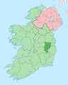
A map showing where County Kildare is located in Ireland.
See also
 In Spanish: Condado de Kildare para niños
