
River Boyne facts for kids
Quick facts for kids River Boyne |
|
|---|---|

River Boyne at Brú na Bóinne.
|
|
| Native name | An Bhóinn |
| Other name(s) | |
| Country | Republic of Ireland |
| Region | Leinster |
| Counties | County Kildare, County Offaly, County Meath, County Louth |
| Physical characteristics | |
| Main source | Trinity Well, Newberry Hall, near Carbury County Kildare |
| River mouth | Irish Sea Between Mornington, County Meath and Baltray, County Louth 53°43′18″N 6°14′17″W / 53.72173°N 6.23813°W |
| Length | 112 km (70 mi) |
| Basin features | |
| Basin size | 2,695 km2 (1,041 sq mi) |
| Tributaries |
|

The River Boyne (called An Bhóinn or Abhainn na Bóinne in Irish) is a river in Leinster, Ireland. It is about 112 kilometers (70 miles) long. The river starts at Trinity Well, Newberry Hall, near Carbury in County Kildare. It then flows northeast through County Meath and empties into the Irish Sea. This happens between Mornington, County Meath and Baltray, County Louth.
You can catch salmon and trout in the river. The area around it is known as the Boyne Valley. The Boyne is crossed by two important bridges near Drogheda. One is the Mary McAleese Boyne Valley Bridge, which carries the M1 motorway. The other is the Boyne Viaduct, which carries the railway line from Dublin to Belfast. The area of land that drains into the River Boyne is 2,695 square kilometers (1,041 square miles). On average, about 38.8 cubic meters (1,370 cubic feet) of water flow through the river every second.
Even though it's not a very long river, the Boyne is super important. It has a rich history, amazing ancient sites, and many cool myths.
Contents
History and Legends of the Boyne
The River Boyne has been known for a very long time. An ancient Greek map from the 2nd century showed Ireland and included the Boyne. It was called Bouwinda or Boubinda back then. Later, in the Middle Ages, people called it the Boandus.
The Battle of the Boyne
One of the most famous events in Irish history happened along the Boyne. This was the Battle of the Boyne in 1690. It was a major battle during the Williamite war in Ireland. The battle took place near Drogheda.
Ancient Sites Along the River
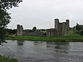
The River Boyne flows past many ancient and important places. These include the old town of Trim and its famous Trim Castle. It also passes the Hill of Tara, which was once the capital of the High Kings of Ireland. Other sites are Navan, the Hill of Slane, and Brú na Bóinne. Brú na Bóinne is a complex of very old stone monuments. The river also goes by Mellifont Abbey and the medieval town of Drogheda. In the wider Boyne Valley, you can find other historical spots like Loughcrew, Kells, ancient Celtic crosses, and old castles.
Myths and Goddesses
In Irish mythology, people believed that the river was created by a goddess named Boann. The name "Boyne" is actually an English version of her name. Another famous legend says that the hero Fionn mac Cumhail caught the magical Salmon of Knowledge in this very river.
Boyne Canal

The Boyne Navigation is a series of canals that run next to the main river. They stretch from Oldbridge near Drogheda all the way to Navan. Most of these canals are old and not used much anymore. However, a group called the Inland Waterways Association of Ireland is working to fix them up. They want to make the canals usable for boats again. The canal section at Oldbridge, which goes through the Battle of the Boyne site, was the first part to be restored.
Amazing Discoveries in the Boyne
The River Boyne has given us some exciting glimpses into the past!
Prehistoric Art Found
In August 2013, a rock with very old carvings was found. These carvings are believed to be Prehistoric art. An expert reported that a large stone with geometric shapes carved into it was found in Donore, County Meath.
Ancient Log-Boat Discovery

In May 2013, the Boyne Fishermen's Rescue and Recovery Service (BFRRS) made an amazing find. They were removing trash from the river near Drogheda, County Louth. Instead, they found an ancient log boat! Experts think this boat might be 5,000 years old. An underwater archaeologist looked at it. They thought it was very special because it had oval shapes on its top edge. These shapes might have held oars, which is rare for log-boats found in the area.
Viking Ship Remains
In 2006, parts of a Viking ship were found in the riverbed in Drogheda. This happened during work to clear the river. The old ship is being carefully dug up because it could be a danger to boats using the river.
Images for kids
-
River Boyne at Trim.
-
River Boyne at Navan.
-
Weir on Boyne near Stackallen
-
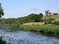
River Boyne at Dunmoe Castle.
-
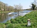
River Boyne upstream from Slane.
-
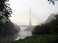
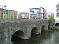
River Boyne passing under the Boyne Cable Bridge in Drogheda.
-
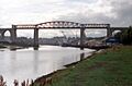
Boyne Viaduct over the River Boyne.
-
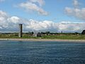
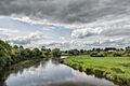
River Boyne at Mornington.
-
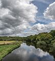
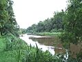
River Boyne at Brú na Bóinne.
-
River Boyne at Brú na Bóinne.
-
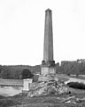
Former Boyne Obelisk, which stood on the north bank of the River Boyne (near Drogheda) from 1736 to 1923.


_-_Glebe,_County_Meath,_Ireland_-_August_8,_2017_-_01.jpg)
_-_Glebe,_County_Meath,_Ireland_-_August_8,_2017.jpg)

See also
 In Spanish: Boyne para niños
