
Boyne Navigation facts for kids
Quick facts for kids Boyne NavigationLoingseoireachta na Bóinne |
|
|---|---|
| Specifications | |
| Length | 31 km (19 miles) |
| Locks | 19 (originally 20) |
| Original number of locks | 20 |
| Status | Being restored by IWAI - Boyne Navigation (voluntary) |
| History | |
| Principal engineer | David Jebb |
| Construction began | 1748 |
| Date closed | 1920s |
| Geography | |
| Start point | Oldbridge, Meath (close to Drogheda) |
| End point | Navan |
| Connects to | River Boyne |

The Boyne Navigation (Irish: Loingseoireachta na Bóinne) is a series of canals in County Meath, Ireland. It runs for 31 kilometers (19 miles) next to the River Boyne, connecting Oldbridge near Drogheda to Navan. In the past, horse-drawn boats used this waterway to carry goods between Navan, Slane, and the port of Drogheda. Today, the navigation is no longer used for commercial transport.
However, a group called the Boyne Navigation branch of the Inland Waterways Association of Ireland is working to restore it. They have an agreement with An Taisce (The National Trust for Ireland) to bring the navigation back to life as a usable waterway.
Contents
.jpg)
The Boyne Navigation is split into two main parts. The Lower Navigation goes from Drogheda to Slane. The Upper Navigation runs from Slane to Navan. Some parts of the route use the river itself, while other parts are man-made canals. Most of the canals are on the south side of the river.
Engineers originally planned to extend the navigation further upstream to Trim. From there, it could have connected to the Royal Canal, linking it to other waterways in Ireland. However, this section was never built.
Work on the Lower Navigation began in 1748 and finished in the 1760s. The Upper Navigation was completed in 1800. The main items transported on the navigation were grain and flour from local mills to Drogheda. Coal was carried in the opposite direction.
At four points along the route, the towpath (where horses walked to pull boats) switched sides of the river. When this happened, the horse would step onto the boat, and the boat would be pushed across to the other side.
David Jebb was the engineer who designed and built the navigation. He even built a large flour mill in Slane in 1766. This mill was the biggest of its kind in Ireland when it opened, showing how important the navigation was for local businesses.
People on the Boyne also used traditional circular boats called Boyne cóireáil (currachs). A group was formed in 1997 to build new versions of these old boats.
The Boyne Navigation was never a huge money-maker. However, it did help the local economy a lot. It made it much easier and cheaper to move farm goods from inland County Meath to the port of Drogheda. This helped farmers and businesses grow.
Building the entire navigation cost about £190,000. Most of this money came from public funds, with some private donations.
Boats using the navigation needed to be able to float in water that was about 1.4 meters (4 feet 8 inches) deep in winter. In summer, the water could be shallower, around 1.1 meters (3 feet 6 inches). Sometimes, low water levels in summer or during low tides meant boats couldn't always travel.
The journey from Drogheda to Slane took about 7 hours in summer and 6 hours in winter. Going from Slane to Navan took 4 hours in summer but 9 hours in winter. This shows how conditions could change the travel time.
Boat owners had to pay a toll to use the navigation. They would then charge people to carry their goods. For example, it cost about 3 shillings per ton to carry freight from Drogheda to Slane.
The navigation has many locks to help boats move up and down different water levels. Some of the locks include:
- Oldbridge Sealock
- Staleen Lower Lock
- Broe Lock
- Morgan's/Rosnaree Lock
- Slane Castle Lock
- Carrickdexter Lock
- Stackallen Lock
- Ruxton's Lock
What's Happening Now
The canal stopped being used for transport around the 1920s and fell into disrepair. In 1969, An Taisce bought the rights to the canal for just one Irish pound. They also own most of the towpaths and land next to the canal.
Today, many volunteers are working hard to restore the Boyne Navigation. Most of the restoration work has focused on the first section near Oldbridge. Here, Lock 1 and Lock 2 have been repaired with new gates. Lock 3 was also dredged (cleaned out) in 2018, and new gates were installed in 2019.
A special group of volunteers works on the Navan section of the navigation. They clear fallen trees and maintain the paths. Other work includes cleaning out parts of the canal and repairing stone walls.
The Oldbridge section is now managed for boats to use. Small boats can travel from Drogheda up to Staleen Lock (Lock 3). This section passes by the famous Newgrange.
The Boyne Navigation section of the I.W.A.I. is the official group doing this restoration work. They work with An Taisce and other landowners. They have active volunteer groups in both Drogheda and Navan.
A local employment group is also helping to restore the Slane section. They have cleared thick plants from the waterway and installed special gates to control water levels. The goal is to allow boats to travel through this section, connecting the Boyne Navigation back to the River Boyne.
Boat Trips and Walking Paths
After trains became popular, the Boyne Navigation was no longer needed for carrying goods. Instead, it started to attract tourists and tour boats. One famous tour boat was called Ros na Righ.
Today, you can still take boat trips on the Oldbridge section. A company called Boyne Boats offers trips where tourists can paddle a traditional Irish boat called a naomhóg. These trips teach visitors about the history of the Boyne Valley.
There are also many walking and cycling paths along the navigation:
- The Boyne Greenway (also called Boyneside Trail) is a path for cycling and walking. It runs along the Oldbridge section.
- Other walking routes include paths from the Battle of the Boyne Centre, from Slane town to Rossnaree Lock, and from Navan to Stackallen Bridge.
Images for kids
-

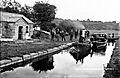
The Boyne Navigation about 3km from Navan, Co. Meath
-
Pleasure boats near Rossnaree and Newgrange in the 1890s
