
County Louth facts for kids
Quick facts for kids
County Louth
Contae Lú
|
||
|---|---|---|
|
||
| Nickname(s):
The Wee County
|
||
| Motto(s): | ||
 |
||
| Country | Ireland | |
| Province | Leinster | |
| Region | Eastern and Midland | |
| Established | 1210 | |
| County town | Dundalk | |
| Largest settlement | Dundalk | |
| Area | ||
| • Total | 826 km2 (319 sq mi) | |
| Area rank | 32nd | |
| Highest elevation | 589 m (1,932 ft) | |
| Population
(2022)
|
||
| • Total | 139,100 | |
| • Rank | 17th | |
| • Density | 168.40/km2 (436.2/sq mi) | |
| Time zone | UTC±0 (WET) | |
| • Summer (DST) | UTC+1 (IST) | |
| Eircode routing keys |
A91, A92 (primarily)
|
|
| Telephone area codes | 041, 042 (primarily) | |
| Vehicle index mark code |
LH | |

County Louth (pronounced LOWDH) is a beautiful coastal county in the east of Ireland. It is part of the Leinster province. Louth is surrounded by other counties: Meath to the south, Monaghan to the west, and Armagh and Down to the north. These northern counties are across Carlingford Lough.
Louth is known as 'The Wee County' because it is the smallest county in Ireland by land area. Even though it's small, it's home to over 139,100 people, making it the 17th most populated county as of 2022. The county gets its name from the village of Louth. The local government for the county is the Louth County Council.
Contents
History of County Louth

County Louth is named after the village of Louth. This village, in turn, was named after Lugh, a powerful god from ancient Irish stories. The name has been spelled in many ways over time, like "Lugmad" and "Lughmhaigh." Today, it's simply Lú in modern Irish.
This county is full of old myths and legends. It's even a setting in the famous Irish tale, the Táin Bó Cúailnge. Long ago, Vikings also came here, and you can still see their influence in names like Carlingford Lough. They even set up a camp called a longphort at Annagassan in the 800s.
Early Settlements and Norman Influence
Many important historical sites are found in Louth. These include old religious places like Monasterboice, Mellifont Abbey, and the St Mary Magdalene Dominican Friary.
Around the 1180s, people called the Normans took over the Louth area. They called it 'English' Oriel to tell it apart from 'Irish' Oriel, which stayed under Irish control.
In the early 1300s, a Scottish army led by Edward Bruce tried to capture Drogheda but failed. Edward Bruce was later defeated and killed in the Battle of Faughart near Dundalk. A local force led by John de Bermingham won this battle.
Town Charters and Changes
Dundalk received a special royal charter in 1189 AD. This happened after a Norman nobleman, Bertram de Verdun, built a manor house there. Later, in 1412, Drogheda also received a royal charter. This charter joined two parts of Drogheda and made it a special 'County in its own right'. Drogheda remained a separate county until 1898. After that, it became part of an expanded County Louth.
Until the late 1500s, Louth was considered part of Ulster. However, after a meeting in 1596, it became part of Leinster.
Battles and Rebellions
The 16th and 17th centuries saw many fights between Irish and English forces in Louth. This was because it was on the main route to 'the Moiry Pass' and the often rebellious areas of Ulster. In 1649, Oliver Cromwell attacked Drogheda, killing many soldiers and citizens.
Later, the armies of King James and King William fought in South Louth. This was before the famous Battle of the Boyne, which took place just 3 km west of Drogheda. Drogheda surrendered to King William the day after that battle.
In 1798, leaders of the Society of United Irishmen from Louth tried to rebel. Sadly, they were betrayed by informers, and several leaders were hanged. A famous priest and scientist, Nicholas Callan, was born in Darver in 1799.
Geography and Size
County Louth is famously known as 'the Wee County' because it is the smallest county in Ireland. It covers an area of 826 square kilometers (319 square miles). Despite its small size, it's the 18th largest county in terms of how many people live there. It is the smallest of Leinster’s 12 counties by size.
Because it's so small but has a good number of people, Louth is the second most densely populated county in the Republic of Ireland. Only Dublin has more people per square kilometer.
Population and Towns
Population Growth
| Historical population | ||
|---|---|---|
| Year | Pop. | ±% |
| 1821 | 119,129 | — |
| 1831 | 124,846 | +4.8% |
| 1841 | 128,240 | +2.7% |
| 1851 | 107,662 | −16.0% |
| 1861 | 90,713 | −15.7% |
| 1871 | 84,021 | −7.4% |
| 1881 | 77,684 | −7.5% |
| 1891 | 71,038 | −8.6% |
| 1901 | 65,820 | −7.3% |
| 1911 | 63,665 | −3.3% |
| 1926 | 62,739 | −1.5% |
| 1936 | 64,339 | +2.6% |
| 1946 | 66,194 | +2.9% |
| 1951 | 68,771 | +3.9% |
| 1956 | 69,194 | +0.6% |
| 1961 | 67,378 | −2.6% |
| 1966 | 69,519 | +3.2% |
| 1971 | 74,951 | +7.8% |
| 1979 | 86,135 | +14.9% |
| 1981 | 88,514 | +2.8% |
| 1986 | 91,810 | +3.7% |
| 1991 | 90,724 | −1.2% |
| 1996 | 92,166 | +1.6% |
| 2002 | 101,821 | +10.5% |
| 2006 | 111,267 | +9.3% |
| 2011 | 122,897 | +10.5% |
| 2016 | 128,884 | +4.9% |
| 2022 | 139,100 | +7.9% |

In 2022, about 139,703 people lived in County Louth. This was a 7.9% increase since 2016. The county has about 169 people per square kilometer, which is more than double the average for Ireland. This makes Louth the second most densely populated county in the Republic of Ireland.
Most of Louth's population, about 69.7%, lives in urban areas. An "urban area" is defined as a town with more than 1,500 people. This means that many parts of the county outside the larger towns are not very crowded.
Louth's population has grown quickly since the 1960s, almost doubling in 50 years. This growth is partly because of its location near the main road between Dublin and Belfast. Many people now live in Drogheda and commute to Dublin for work.
In 2016, Louth's population became larger than it was before the Great Famine in 1841. This is a big achievement, as only a few counties in Ireland have done this.
Main Towns
The county has two main population centers: Dundalk in the north and Drogheda in the south. Together, these two towns are home to almost 60% of the county's total population. They are the 6th and 7th largest urban areas in Ireland.
Drogheda is generally larger, but a part of it is in County Meath. So, Dundalk is the largest town completely within Louth and is also the county town.
| Drogheda (44,135) |
Dundalk (43,112) |
Ardee (5,478) |
Clogherhead (2,275) |
Dunleer (2,143) |
Termonfeckin (1,983) |
Tullyallen (1,697) |
Carlingford (1,528) |
| Dromiskin (1,292) |
Castlebellingham (1,232) |
Collon (864) |
Omeath (778) |
Knockbridge (759) |
Louth (717) |
Tallanstown (668) |
Tinure (530) |


People from Different Backgrounds
In 2016, most people in County Louth (91.5%) were white. About 83% identified as White Irish. Other groups included black people (2.8%), Asian people (1.9%), and people of mixed race (1.4%). Most of these groups live in Dundalk or Drogheda.
Louth has a high number of people who were born in the county. About two-thirds (66.2%) of Louth residents were born there. This is different from some other nearby counties, where many people have moved from Dublin.
People from Northern Ireland make up the largest group of people born outside the Republic of Ireland in Louth. Other large groups include people from Poland, Lithuania, Nigeria, and Latvia.
Irish Language in Louth
The Cooley Peninsula was once a place where the Irish language was commonly spoken. This area was known as a Gaeltacht. People spoke a special local dialect called Gaelige Oriel. The last native speaker of this dialect passed away in 1960.
Even though it had a historic Gaeltacht, Louth now has the lowest percentage of Irish speakers in Ireland. In 2016, only 34.1% of the population said they could speak Irish.
Religion in Louth

| Religion in Louth (2016) | ||||
|---|---|---|---|---|
| religion | percent | |||
| Catholic | 81.6% | |||
| No religion | 7.7% | |||
| Other Christian | 5.8% | |||
| Not Stated | 2.4% | |||
| Islam | 1.4% | |||
| Other faith | 1.1% | |||
The Catholic Church is the largest religious group in County Louth, with over 105,000 members. Other Christian groups, like the Church of Ireland, are also present. There are also many Muslims and Orthodox Christians living in the county.
Interestingly, the number of people who said they had no religion or were atheist grew a lot between 2011 and 2016. This group now makes up almost 8% of the county's population.
Fun Places to Visit
- Carlingford Lough
- Cooley Peninsula
- County Museum Dundalk
- King John's Castle (Carlingford)
- Linn Duachaill
- Magdalene Tower, Drogheda
- Mellifont Abbey
- Millmount Fort
- Monasterboice
- St. Laurence's Gate
- St. Peter's Roman Catholic Church, Drogheda, where the head of St. Oliver Plunkett is kept.
Famous People from Louth
Actors and Musicians
- Pierce Brosnan – Famous actor, known for playing James Bond
- Andrea Corr – Singer from the band The Corrs
- Caroline Corr – Musician from The Corrs
- Jim Corr – Musician from The Corrs
- Sharon Corr – Musician from The Corrs
- Evanna Lynch – Actress, known for Harry Potter
- Colin O'Donoghue – Actor, from Once Upon a Time
Sports Stars
- Nick Colgan – Footballer
- Gary Kelly – Footballer, played for Leeds United
- Robert Kearney – Irish Rugby player
- Steve Staunton – Footballer
Other Notable People
- Fr Nicholas Joseph Callan – Priest and scientist, known for his work on the induction coil.
- Katherine Plunket – An Irish aristocrat and artist who lived to be 111 years old!
- Peter Rice – A very important Structural engineer.
Images for kids
-
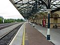
Dundalk railway station
-
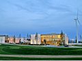
Dundalk IT.
-
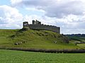
Castle Roche
-
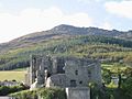
Slive Foy and King John's Castle
-
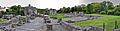
Mellifont Abbey
-
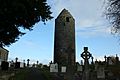
Dromiskin Round Tower
-
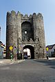
Drogheda, St. Laurences Gate
-
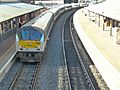
Drogheda railway station with the Enterprise
-
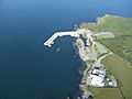
Clogherhead Harbour
-
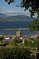
Carlingford Harbour


.jpg)


See also
 In Spanish: Condado de Louth para niños
