
Ulster facts for kids
Quick facts for kids
Ulster
|
|||
|---|---|---|---|
|
|||
 |
|||
| Sovereign states | United Kingdom Republic of Ireland |
||
| Counties | Antrim (UK) Armagh (UK) Cavan (ROI) Donegal (ROI) Down (UK) Fermanagh (UK) Londonderry (UK) Monaghan (ROI) Tyrone (UK) |
||
| Area | |||
| • Total | 22,067 km2 (8,520 sq mi) | ||
| Area rank | 2nd | ||
| Population
(2022 estimate)
|
|||
| • Total | 2,215,454 | ||
| • Rank | 2nd | ||
| • Density | 100.3967/km2 (260.03/sq mi) | ||
| Time zone | UTC±0 (GMT/WET) | ||
| • Summer (DST) | UTC+1 (BST/IST) | ||
| Postcodes |
Northern Ireland: BT
Donegal: Eircodes beginning with F Cavan and Monaghan: Eircodes beginning with A or H7 |
||
| Telephone area codes | Northern Ireland: 028 (from Great Britain) 048 (from Republic of Ireland) +44-28 (from rest of world) Donegal: +353-74 Cavan and Monaghan: +353-4x |
||
| ISO 3166 code | IE-U (Republic of Ireland) GB-NIR (Northern Ireland) |
||
| Patron Saints: Finnian of Moville and Columba
a. The Northern Ireland Statistics and Research Agency census of 2021 results (1,903,100) combined with the preliminary results of 2022 census of Ireland for Ulster (part of; 312,354). b. The counties of Cavan, Monaghan and Donegal are part of the Midlands–North-West constituency (4 MEPs); these three counties contain 19.5% of the population of the constituency. Following Brexit, as the United Kingdom left the EU, there are no MEPs from Northern Ireland. |
|||


Ulster (Irish: Ulaidh or Cúige Uladh, Ulster Scots: Ulstèr or Ulster) is one of the four main historic regions of Ireland. It has nine counties. Six of these counties are part of Northern Ireland, which is in the United Kingdom. The other three counties are in the Republic of Ireland.
Ulster is the second largest and second most populated of Ireland's four traditional provinces. Belfast is its biggest city. Unlike other Irish provinces, Ulster has many Protestants, making up almost half its population. English is the main language. A special way of speaking English, called Ulster English, is common. Some people also speak Irish, especially in Irish-speaking areas in County Donegal. There are also Irish speakers in southern County Londonderry and in Belfast. Ulster-Scots is also spoken in Counties Antrim, Down, Londonderry, Tyrone, and Donegal.
Lough Neagh, in eastern Ulster, is the largest lake in the British Isles. Lough Erne in the west is a large network of lakes. Important mountains include the Mournes, Sperrins, Croaghgorms, and Derryveagh Mountains.
Long ago, Ulster was a key part of the Gaelic world, which included Gaelic Ireland, Scotland, and the Isle of Man. In ancient times, it was one of the "fifths" (cúige) ruled by a powerful king. The province is named after the ancient kingdom of Ulaid in the east. After the Normans arrived in the 1100s, eastern Ulster was taken over and became the Earldom of Ulster. By the late 1300s, this Earldom fell apart. The O'Neill dynasty then became very powerful across most of Ulster.
Ulster was the most independent and Gaelic part of Ireland. Its rulers fought against English control but were defeated in the Nine Years' War (1594–1603). After this, King James I brought English-speaking Protestant settlers from Great Britain to Ulster. This event, called the Plantation of Ulster, led to many towns being founded.
Ulster became part of the United Kingdom in 1801. In the early 1900s, many Ulster Protestants did not want Ireland to govern itself. This led to the Home Rule Crisis. After the Irish War of Independence, Ireland was divided. Six Ulster counties became Northern Ireland, a part of the United Kingdom. The other three counties joined the Irish Free State, which is now the Republic of Ireland.
Today, "Ulster" is not an official government term in either country. However, it is used by many cultural and sports groups.
Contents
What is Ulster?
The name Ulster comes from the Ulaidh, a group of tribes who lived in this part of Ireland long ago. The Norse people called the province Ulaztir, meaning the "land" (tír) of the Ulaidh. This name then became "Ulster" in English.
In Irish, Ulster is still called Cúige Uladh. This means the "province" or "fifth" of the Ulaidh. The Irish word for someone from Ulster is Ultach. This word is found in surnames like MacNulty.
Sometimes, people refer to Northern Ireland as "Ulster," even though it only includes six of Ulster's nine counties. This is common among people in Northern Ireland who support staying in the UK. However, many Irish nationalists do not like this use of the name.
Geography and People

Ulster has about 2.2 million people and covers an area of 22,067 square kilometers (8,520 square miles). About 62% of Ulster's land is in the UK, and 38% is in the Republic of Ireland.
Belfast is Ulster's largest city, with over half a million people. It is the second-largest city on the island of Ireland.
Six of Ulster's nine counties are in Northern Ireland. These are Antrim, Armagh, Down, Fermanagh, Londonderry, and Tyrone. The other three counties – Cavan, Donegal, and Monaghan – are in the Republic of Ireland. About half of Ulster's population lives in Counties Antrim and Down.
Across all nine counties, more people are Roman Catholic (50.8%) than Protestant (42.7%).
In the Republic of Ireland, the traditional counties are still used for local government. But in Northern Ireland, since 1974, the counties are mostly for ceremonial purposes. Local government there is now divided into 11 districts.
Counties of Ulster
Here are the counties of Ulster with their populations and areas:
| County | Population | Area |
|---|---|---|
| County Antrim (Contae Aontroma; Coontie Anthrim/Antrìm/Antrim/Entrim) | 618,108 | 3,088 km2 (1,192 sq mi) |
| County Armagh (Contae Ard Mhacha; Coontie Airmagh/Armagh) | 174,792 | 1,327 km2 (512 sq mi) |
| County Cavan (Contae an Chabháin) | 81,201 | 1,932 km2 (746 sq mi) |
| County Donegal (Contae Dhún na nGall/Thír Chonaill; Coontie Dunnygal/Dinnygal) | 166,321 | 4,861 km2 (1,877 sq mi) |
| County Down (Contae an Dúin; Coontie Doon/Doun) | 531,665 | 2,489 km2 (961 sq mi) |
| County Fermanagh (Contae Fhear Manach; Coontie Fermanagh/Fermanay) | 61,170 | 1,691 km2 (653 sq mi) |
| County Londonderry (Contae Dhoire; Coontie Loonenderrie) | 247,132 | 2,118 km2 (818 sq mi) |
| County Monaghan (Contae Mhuineacháin) | 64,832 | 1,295 km2 (500 sq mi) |
| County Tyrone (Contae Thír Eoghain; Coontie Tyrone/Owenslann) | 177,986 | 3,266 km2 (1,261 sq mi) |
| Total | 2,123,207 | 22,067 km2 (8,520 sq mi) |
Counties shaded in grey are in the Republic of Ireland. Counties shaded in pink are in Northern Ireland.
Major Towns and Cities
Here are the largest towns and cities in Ulster, based on their population:
- Belfast (480,000)
- Derry (105,000)
- Lisburn (75,000)
- Craigavon (65,000)
- Bangor (58,400)
- Ballymena (28,700)
- Newtownards (27,800)
- Newry (27,400)
- Carrickfergus (27,200)
- Coleraine (25,000)
- Antrim (20,000)
- Omagh (19,800)
- Letterkenny (19,600)
- Larne (18,200)
- Banbridge (14,700)
- Armagh (14,500)
Ulster's Economy
The total economic output (GDP) of Ulster is about €50 billion. However, salary levels in Ulster are the lowest on the island of Ireland.
Physical Geography
Lough Neagh, the largest lake in the British Isles, is in eastern Ulster. The highest point in the province is Slieve Donard (848 meters or 2,782 feet) in County Down.
Malin Head in County Donegal is the most northerly point in Ireland. County Donegal also has the sixth-highest sea cliffs in Europe, at Slieve League. The largest island in Ulster, Arranmore, is also here.
The longest river in the British Isles, the Shannon, starts in County Cavan. Volcanic activity in eastern Ulster created the Antrim Plateau and the Giant's Causeway. The Giant's Causeway is one of Ireland's three UNESCO World Heritage Sites. Ulster also has many drumlins, which are small, oval hills formed by glaciers.
The center of Ulster is between the villages of Pomeroy and Carrickmore in County Tyrone. County Donegal is the largest county in Ulster by area.
Images for kids
-
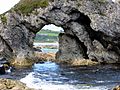
At White Park Bay
-
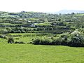
Countryside west of Ballynahinch
-
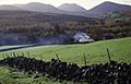
Mourne country cottage
-
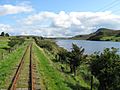
The track of the County Donegal Railways Joint Committee (CDRJC) restored next to Lough Finn, near Fintown station.
-
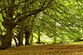
The approach of autumn, Tardree forest


.jpg)

Getting Around Ulster: Transport
Air Travel
Ulster's main airport is Belfast International Airport, located near Antrim. Another smaller airport in Belfast is George Best Belfast City Airport. The City of Derry Airport is near Derry. There is also Donegal Airport in The Rosses.
Rail Travel
Northern Ireland Railways (NIR) runs the train lines. The routes from Belfast to Bangor and Belfast to Lisburn are very important. The Belfast-Derry railway line is known for its beautiful scenery. Belfast also has train links to Carrickfergus, Larne Harbour, Portadown, and Newry. From Newry, you can take the Enterprise service to Dublin Connolly in the Republic of Ireland.
Some counties in Ulster (Cavan, Monaghan, Fermanagh, Tyrone, and Donegal) currently do not have mainline railway services.
Languages Spoken in Ulster
Most people in Ulster speak English. The Irish (Gaeilge) is taught in schools in the Republic of Ireland counties and in some schools in Northern Ireland. In 2001, about 10% of people in Northern Ireland knew some Irish. Large parts of County Donegal are Gaeltacht areas, where Irish is the main language. Some people in west Belfast also speak Irish. The Irish dialect spoken in Ulster is called Gaeilge Uladh or Ulster Irish. It is similar to Scottish Gaelic.
Polish is the third most common language. Ulster Scots dialects, sometimes called Ullans, are also spoken in Counties Down, Antrim, Londonderry, and Donegal.
Ulster's Past: A Quick Look
Early Times
Ulster is one of Ireland's four historic provinces. Its name comes from the Irish Cúige Uladh, meaning "fifth of the Ulaidh," named after the ancient people of the area.
Ulster's early history is known through legends like the Ulster Cycle. Old sites like the Giant's Ring near Belfast show how people lived long ago.
In the early Middle Ages, a group called the Northern Uí Néill slowly took over parts of Ulster. Their base was in Tír Eóghain (now County Tyrone). Important kings like Áed Findliath and Niall Glúndub came from this group. The original province of Ulaidh became smaller, located east of the River Bann. After the Norman invasion of Ireland in the 1100s, the eastern part of Ulster was conquered by Norman lords.
Later, in the mid-1300s, the Norman Earldom of Ulster collapsed. The O'Neill dynasty became very powerful and claimed the title "king of Ulster." This is when the different ancient kingdoms in Ulster largely merged into what we know as the modern province.
The O'Donnell family was another powerful clan in Ulster from the 1200s to the 1600s. They ruled over Tír Chonaill (most of modern County Donegal).
By the 1600s, Ulster was the last place where the traditional Gaelic way of life was strong. But after the Irish forces lost the Nine Years War (1594–1603), England took control of Ulster and all of Ireland.
In 1607, the Gaelic leaders of Ulster, the O'Neills and O'Donnells, left Ireland in what is known as the Flight of the Earls. This allowed the English Crown to bring in more loyal English and Scottish Protestant settlers. This process, called the Plantation of Ulster, began in 1610.

Plantations and Conflicts
The Plantation of Ulster was an organized effort to settle Ulster with people from Great Britain, especially Presbyterians from Scotland. Land owned by Irish chiefs who fought against the English was taken and given to these new settlers. This led to the founding of many towns.
The Plantation was interrupted by the Irish Rebellion of 1641. This rebellion began with attacks on the new settlers. Ulster became a battlefield between the settlers and the native Irish. The war ended with the defeat of the Irish army in 1650.
Forty years later, from 1688 to 1691, the Williamite War took place. This war was partly about who should be the ruler of Britain. Most Irish people supported King James II, while most Ulster settlers supported William of Orange. The settlers in Derry and Enniskillen held out against attacks. William's forces eventually won the war. This victory led to British rule in Ireland for over 200 years.
After the war, Anglican Protestants (mostly English settlers) had the most power. Roman Catholics and Presbyterians (mostly Scottish settlers) faced discrimination. In the 1690s, Scottish Presbyterians became the majority in Ulster.
Emigration from Ulster
Many Ulster-Scots people moved to North America in the 1700s. They settled in places like the Appalachian regions and the Ohio Valley. These settlers, often called "Scots Irish" or "Scotch-Irish," helped shape American culture.
Political Changes and Division
The 1700s saw fewer religious tensions in Ulster. The economy grew, and Belfast became a busy town. However, many thousands of Ulster people still moved to North America.
Political tensions returned in the late 1700s. Many Roman Catholics and Presbyterians joined the United Irishmen movement. This group wanted to create an independent Irish republic where religion did not matter. However, there was also violence between Roman Catholics and Protestants, especially in 1795, which led to the founding of the Orange Order.
In 1798, the United Irishmen started a rebellion in Ulster, mostly supported by Presbyterians. But the British quickly stopped it. After this, and as religious discrimination ended, Presbyterians began to feel more connected to the state and their Anglican neighbors.

In the 1800s, Ulster became the most successful province in Ireland due to its industries. Belfast grew into the island's largest city for a short time, famous for its shipbuilding, including the RMS Titanic.
Divisions in Ulster became clearer, with people identifying as unionist (supporting the link with Britain, mostly Protestant) or nationalist (wanting Ireland to be independent, mostly Roman Catholic). These disagreements led to the current political situation in Northern Ireland. Many Ulster Protestants were against Home Rule (Ireland governing itself) because they worried about their religious rights and the economy.
Thousands of unionists signed the "Ulster Covenant" in 1912, promising to resist Home Rule. They also formed the Ulster Volunteer Force (UVF). In 1914, the UVF brought in many German rifles. In response, Irish republicans formed the Irish Volunteers.
When World War I started in 1914, the conflict in Ireland paused. But as the war continued, opposition to it grew.
After World War I, the political party Sinn Féin won most votes in the 1918 Irish general election. They wanted full independence for Ireland. This led to the Irish War of Independence (1919–1921). In Ulster, the fighting often involved street battles between Protestants and Roman Catholics in Belfast.
Ulster Today: 1920 to Present
_map_-_winning_party_vote_share_by_constituency.svg)
The partition of Ireland was planned in 1912 and became law with the Government of Ireland Act 1920. This law created two self-governing areas: Southern Ireland and "Northern Ireland" (six of Ulster's counties). Both were still part of the United Kingdom of Great Britain and Ireland.
The Irish War of Independence ended in 1921. The Anglo-Irish Treaty of 1921 turned Ireland into the Irish Free State, a self-governing British dominion. Northern Ireland had the choice to stay in the United Kingdom, which it did.
The exact border between the Irish Free State and Northern Ireland was decided by the Irish Boundary Commission in 1925. The border remained around the same six counties of Ulster.
In Northern Ireland, voting often follows religious lines. However, in the Republic of Ireland counties of Cavan, Monaghan, and Donegal, this is not the case. The Orange Order holds parades in counties Donegal, Cavan, and Monaghan, including a major one in Rossnowlagh, County Donegal, each July.
The historic Flag of Ulster was the basis for the Ulster Banner, which was the flag of the Government of Northern Ireland until 1973.
Sports in Ulster
Gaelic Games
In Gaelic games (like Gaelic football and hurling), Ulster counties compete in the Ulster Senior Football Championship and Ulster Senior Hurling Championship. They also play against other Irish counties in national competitions like the All-Ireland Senior Football Championship. Gaelic Football is very popular in Ulster, but hurling is also played, especially in Antrim, Armagh, Derry, and Down.
Association Football (Soccer)
Since 1921, the border has divided soccer teams. The Irish Football Association (IFA) manages the sport in Northern Ireland, while the Football Association of Ireland (FAI) manages it in the Republic. This means there are separate international teams and leagues. Interestingly, Derry City F.C. plays in the League of Ireland (Republic of Ireland's league) even though Derry is in Northern Ireland. Another major Ulster team in the League of Ireland is Finn Harps from County Donegal.
Rugby Union
Ulster Rugby is the professional rugby team for the province. They play in the Pro14 league against teams from Wales, Scotland, Italy, and South Africa, as well as other Irish provinces. They also compete in the European Rugby Champions Cup, which they won in 1999. Famous Ulster rugby players include Willy John McBride and Mike Gibson. Players from Ulster also join with those from the other three provinces to form the all-island Ireland team.
Other Sports
The Ulster Hockey Union organizes field hockey in the province. Cricket is also played, especially in Northern Ireland and East Donegal.
Golf is a very high-profile sport in Ulster, with many great players coming from the region. These include Fred Daly, Rory McIlroy, Darren Clarke, and Graeme McDowell, all of whom have won major championships. The Open Championship returned to Ulster in 2019 at Royal Portrush Golf Club.
In horse racing, Tony McCoy from Ulster is one of the most successful jockeys of all time.
The Circuit of Ireland Rally is an annual car rally held in Ulster since 1931.
See also
 In Spanish: Úlster para niños
