
Ohio River facts for kids


The Ohio River is a long river in the United States, stretching for about 981-mile-long (1,579 km). It forms a natural border between the Midwest and the Southern United States. The river flows southwest from western Pennsylvania until it joins the mighty Mississippi River in Illinois.
The Ohio River is a very important waterway. It carries the third largest amount of water in the U.S. and is the biggest river that flows into the Mississippi. It's also one of the oldest rivers in North America. The river touches or borders six states, and its drainage basin (the area of land where all the water drains into the river) covers parts of 14 states. Millions of people rely on the Ohio River for their drinking water.
Long ago, the Ohio River was a key route for pioneers moving west. Parts of the river, like the Falls of the Ohio near Louisville, had rapids that made it hard for big boats to pass. But canals and locks were built to help boats travel easily. Today, the river isn't free-flowing; it has 20 locks and dams that create 21 pools of water. These help with navigation and power generation.
The name "Ohio" comes from the Seneca language, meaning "Good River." In the late 1700s, the river became an important boundary. It separated colonial lands from Native American lands and later, free states from states where slavery was allowed. Many enslaved people bravely crossed the Ohio River to find freedom in the North.
The Ohio River is a place where different climates meet. It has plants and animals from both warm and cooler regions. Sadly, it is also one of the most polluted rivers in the United States.
Contents
What Does "Ohio" Mean?
The name "Ohio" comes from the Seneca language, which is an Iroquoian language. The word is Ohi:yo (pronounced oh-hee-yoh), and it means "Good River." Some people also translate it as "Great River" or "large creek."
Native American groups like the Lenape and Iroquois thought of the Ohio and Allegheny rivers as the same river. This shows how important this waterway was to them.
Another old name for the Ohio River was Mosopeleacipi from the Miami-Illinois language, meaning "river of the Mosopelea tribe." This name changed over time to "Pelisipi" or "Pellissippi."
A Look Back: History of the Ohio River
The Ohio River has a rich history, especially for Native American tribes. For thousands of years, they used the river as a major way to travel and trade. Many ancient civilizations built their homes and large mounds along its banks.
Early European Explorers
Europeans started exploring the Ohio River in the late 1600s. People like Abraham Wood, Robert de La Salle, and Arnout Viele were among the first to travel its waters.
Arnout Viele's Journey (1693)
In 1692, a Dutchman named Arnout Viele, along with eleven companions, explored western Pennsylvania and the upper Ohio Valley. He was sent by the governor of New York to trade with the Shawnee people. Viele could speak several Native American languages, which helped him a lot. He traveled as far west as the Wabash River in what is now Indiana.
Viele and his group spent most of 1693 exploring the Ohio River and its smaller rivers in northern Kentucky. They returned in 1694 with Native American diplomats who wanted to trade with the English.
Mapping the River (1729)
In 1729, a French architect and surveyor named Gaspard-Joseph Chaussegros de Léry created the first map of the Ohio River. He led French soldiers down the Allegheny River and Ohio Rivers. His team even found very old bones, which were later identified as mastodon remains. These bones are now in a museum in Paris, France.
Virginia Explorers (1742)
In 1742, a pioneer from Virginia named John Howard led a group of five men on an expedition. They traveled from the Virginia mountains all the way to the Mississippi River. They built a boat out of buffalo skins and followed rivers until they reached the Ohio River. They explored the northern border of Kentucky for about five hundred miles (800 km) before reaching the Mississippi River.
Conflict and Settlement
In 1749, the Ohio Company was formed to settle and trade in the Ohio River region. This led to disagreements between British colonists and the French, who also claimed the area. This conflict grew into the French and Indian War. After the war, in 1763, France gave up its lands east of the Mississippi River to Britain.
The Ohio River became an important border. The 1768 Treaty of Fort Stanwix made it the southern boundary for Native American lands. Later, after the American Revolutionary War, the entire Ohio Valley became part of the United States. Many settlers then moved into the region.

Travel to the Ohio River became easier in 1818 when the National Road reached Wheeling, West Virginia. The Wheeling Suspension Bridge, built there between 1847 and 1849, was the first bridge across the river. For a short time, it was the world's longest suspension bridge!
Louisville, Kentucky, was founded in 1778 near the Falls of the Ohio. These rapids made it hard for boats to pass. To solve this, the Louisville and Portland Canal (now McAlpine Locks and Dam) was built between 1825 and 1830. This allowed boats to go around the falls. Over the years, these locks and dams were improved to handle larger ships.
Life on the River in the 1800s
During the 1800s, many people from Virginia, North Carolina, and Kentucky traveled along the Ohio River to settle in southern Ohio, Indiana, and Illinois. They were mostly farmers and sent their goods down the river to cities like Cincinnati.
.jpg)
The Ohio River was a main route for pioneers heading west. After reaching the Ohio's mouth, settlers would travel north on the Mississippi River to St. Louis, Missouri. From there, they continued their journeys. In the early 1800s, some river pirates, like Samuel Mason, attacked travelers on the river.
Trading boats and ships traveled south on the Mississippi to New Orleans. This was a vital way to export goods from the west, as traveling east over the Appalachian Mountains was very difficult. The need for access to New Orleans was one reason the U.S. made the Louisiana Purchase in 1803.
The River as a Border to Freedom
Before the American Civil War, the Ohio River was a border between states where slavery was legal and states where it was not. Enslaved people often called it the "River Jordan" because it was their path to freedom in the North. Thousands of enslaved people risked everything to cross the Ohio River, often with help from the Underground Railroad.
Stories of these brave escapes, like those in Harriet Beecher Stowe's famous book Uncle Tom's Cabin and Toni Morrison's novel Beloved, highlight the river's role in this challenging time.
State Border Issues
The original colonial charter for Virginia said its land extended to the north shore of the Ohio River. This meant Virginia "owned" the riverbed. Today, the river belongs to the states on its east and south sides, like West Virginia and Kentucky.
For example, Wheeling Island, the largest inhabited island in the Ohio River, belongs to West Virginia, even though it's closer to Ohio. There have been legal disputes over the river's exact border, especially concerning water use and taxes on riverboat casinos. The U.S. Supreme Court decided that Kentucky's (and West Virginia's) control only goes to the low-water mark of 1793.
Silver Bridge Collapse (1967)

On December 15, 1967, the Silver Bridge at Point Pleasant, West Virginia, suddenly collapsed into the river. This terrible event killed 46 people who were crossing it. The bridge, built in 1929, was carrying too much weight for its design. A new bridge, the Silver Memorial Bridge, was built nearby and opened in 1969.
Conservation Efforts
In the early 1980s, the Falls of the Ohio National Wildlife Conservation Area was created in Clarksville, Indiana. This area helps protect the natural beauty and wildlife around the falls.
River Health: Pollution Concerns
The Ohio River is unfortunately known as one of the most polluted rivers in the United States. Data from recent years shows it often ranks as the most polluted. A group called the Ohio River Valley Water Sanitation Commission (ORSANCO) found that most of the pollution comes from nitrates, which are found in farm runoff and waste water from factories. Mercury pollution is also a big problem.
For many years, a chemical company called DuPont released a harmful chemical called PFOA into the river from its facility in Parkersburg, West Virginia. The Ohio River was even listed among "America's Most Endangered Rivers" in 2023, partly due to a recent train derailment that caused more contamination.
Economy and Industry on the Ohio River

The Ohio River is a very busy waterway for industry and trade. Large barges regularly carry oil, steel, and other factory goods. Many important cities are located along the river, including Pittsburgh, Pennsylvania; Louisville, Kentucky; Evansville, Indiana; and Cincinnati, Ohio.
River Geography and Flow
The Ohio River, combined with the Allegheny River, is about 1,310 miles (2,110 km) long. It carries the largest amount of water of any river that flows into the Mississippi. Long ago, Native Americans and early European explorers often thought of the Allegheny as part of the Ohio. The meeting point of the Allegheny and Monongahela rivers in Pittsburgh was always seen as a very important military spot.

The Ohio River officially begins where the Allegheny River and Monongahela River meet in Pittsburgh, Pennsylvania. From there, it flows northwest, then turns sharply southwest. It forms the border between West Virginia and Ohio, and then between Kentucky and Ohio, Indiana, and Illinois. Finally, it joins the Mississippi River at Cairo, Illinois. The spot where the Ohio meets the Mississippi is the lowest point in Illinois.
The Ohio River is the largest river by water volume that flows into the Mississippi River. In fact, at their meeting point, the Ohio River actually carries more water than the Mississippi River! This means that, in terms of water flow, the Ohio River is the main stream of the entire river system.
How Deep is the Ohio River?

The Ohio River was naturally shallow, but a series of dams have made it much deeper. Its natural depth used to be between 3 to 20 feet (1 to 6 m). The dams raise the water level, turning the river into a series of reservoirs. This helps commercial boats travel easily.
From its start to Cincinnati, the river is about 15 feet (5 m) deep on average. The biggest drop in water level is at the Falls of the Ohio in Louisville, Kentucky. The deepest point of the river is 168 feet (51 m) deep, also near Louisville. As the river flows towards the Mississippi at Cairo, Illinois, its depth gradually decreases to about 19 feet (6 m).
The National Oceanic and Atmospheric Administration (NOAA) provides daily predictions for the Ohio River's water levels. These predictions help people know how deep the water will be in different parts of the river.

Major Rivers Joining the Ohio
Many other rivers flow into the Ohio River. These are called tributaries. Here are some of the largest ones:
- The Tennessee River
- The Cumberland River
- The Wabash River
- The Allegheny River
- The Kanawha River
- The Green River
- The Monongahela River
- The Kentucky River
- The Muskingum River
- The Scioto River
Ohio River's Drainage Area
The Ohio River's drainage basin is huge, covering about 189,422 square miles (490,600 km2). This area includes parts of 14 states across different regions of the U.S.:
- Northeast: Small parts of New York and Pennsylvania.
- Mid-Atlantic/Upper South: Parts of Maryland, most of West Virginia, nearly all of Kentucky, most of southwest Virginia, and the western quarter of North Carolina.
- Midwest: Most of Ohio and Indiana, and the southeast part of Illinois.
- Deep South: The far northwest corner of Georgia, the northern part of Alabama, and the northeast corner of Mississippi.
Climate and the Ohio River
The Ohio River is in a special climate zone. Its waters flow along the edge of two different climate types: humid continental and humid subtropical. This means you can find plants and animals from both types of climates here.
In winter, the river often freezes over near Pittsburgh. But farther south, closer to Cincinnati and Louisville, it rarely freezes. In places like Paducah, Kentucky, near where it meets the Tennessee River, the Ohio River stays ice-free all year.
In recent years, the humid subtropical climate zone has been expanding. It now reaches across the river into the southern parts of Ohio, Indiana, and Illinois.
How the Ohio River Was Formed
From a geology point of view, the Ohio River is quite young. Before it existed, a huge saltwater lake covered large parts of North America. The rocks under the Ohio Valley were formed during that time.
The Ohio River started to form in pieces about 2.5 to 3 million years ago. As huge glaciers moved during the ice ages, they changed the paths of older rivers. Rivers like the Kanawha, Sandy, Kentucky, Green, Cumberland, and Tennessee rivers, which used to flow north, helped create the Ohio River system. The Teays River was one of the biggest ancient rivers, and parts of the modern Ohio River flow along its old path.
The section of the river that flows southwest from Pittsburgh to Cairo, Illinois, is only tens of thousands of years old.
Upper Ohio River Formation
The upper part of the Ohio River formed when a large glacial lake overflowed into a river that flowed south. Before this, two rivers, the Steubenville River (flowing north) and the Marietta River (flowing south), ended separately. The overflowing lake cut through the hill between them, connecting the two rivers. This flood made the small Marietta valley much larger, creating the wide river we see today.
Middle Ohio River Formation
The middle part of the Ohio River formed in a similar way. A river that flowed north was temporarily blocked by natural forces southwest of Louisville. This created a large lake until the natural dam broke. The water then carved a new path to the Mississippi. Eventually, the upper and middle sections of the river joined to form the Ohio River as we know it.
Cities and Towns Along the Ohio River
Many important cities are located along the banks of the Ohio River. These include:
- Pittsburgh, Pennsylvania, the third-largest city on the river.
- Cincinnati, Ohio, the second-largest city on the river.
- Louisville, Kentucky, the largest city on the river and in Kentucky.
- Evansville, Indiana, the third-largest city in Indiana.
- Owensboro, Kentucky, the fourth-largest city in Kentucky.
- Huntington, West Virginia, Parkersburg, West Virginia, and Wheeling, West Virginia, which are among the largest cities in West Virginia.
Many of these cities are also very old, some of the oldest in the United States west of the Appalachian Mountains. For example, Old Shawneetown, Illinois, was founded in 1748, and Pittsburgh in 1758.
Other interesting cities include Cairo, Illinois, where the Ohio River meets the Mississippi. It's the southernmost and westernmost city on the river. Beaver, Pennsylvania, is the northernmost city. Even though it's 548 miles (882 km) as the crow flies between Cairo and Pittsburgh, it's 981 miles (1,579 km) by water because of the river's winding path.
Before cities, there were many forts along the Ohio River. These forts were very important during the French and Indian War and for early settlers. Many cities grew up around these old forts.
Images for kids
-
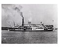
Steamboat Morning Star in 1858.
-
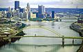
The Allegheny River, left, and Monongahela River join to form the Ohio River at Pittsburgh, Pennsylvania, the largest metropolitan area on the river.
-
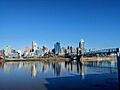
Cincinnati, Ohio, skyline showing the John A. Roebling Suspension Bridge to Covington, Kentucky
-

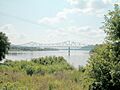
Louisville, Kentucky. The deepest point of the Ohio River is a scour hole just below Cannelton locks and dam (river mile 720.7).
-
A barge hauls coal in the Louisville and Portland Canal, the only artificial portion of the Ohio River.
-
Carl Perkins Bridge in Portsmouth, Ohio, with Ohio River and Scioto River tributary on right
-
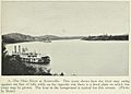
The Ohio River seen at Sciotoville, from the "Geography of Ohio," 1923
-
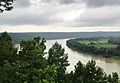
The Ohio River as seen from Fredonia, Indiana
-
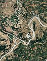
Natural-color satellite image of the Wabash-Ohio confluence
-
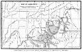
Glacial Lake Ohio


_(cropped2).jpg)


.jpg)
See also
 In Spanish: Río Ohio para niños
