
Georgia (U.S. state) facts for kids
Quick facts for kids
Georgia
|
|||||||||||||||||||||||
|---|---|---|---|---|---|---|---|---|---|---|---|---|---|---|---|---|---|---|---|---|---|---|---|
|
|||||||||||||||||||||||
| Nicknames:
Peach State; Empire State of the South
|
|||||||||||||||||||||||
| Motto(s):
"Wisdom, Justice & Moderation"
|
|||||||||||||||||||||||
| Anthem: "Georgia on My Mind" | |||||||||||||||||||||||

Location of Georgia within the United States
|
|||||||||||||||||||||||
| Country | United States | ||||||||||||||||||||||
| Before statehood | Province of Georgia | ||||||||||||||||||||||
| Admitted to the Union | January 2, 1788 (4th) | ||||||||||||||||||||||
| Capital (and largest city) |
Atlanta | ||||||||||||||||||||||
| Largest county or equivalent | Fulton | ||||||||||||||||||||||
| Largest metro and urban areas | Atlanta | ||||||||||||||||||||||
| Legislature | Georgia General Assembly | ||||||||||||||||||||||
| • Upper house | Senate | ||||||||||||||||||||||
| • Lower house | House of Representatives | ||||||||||||||||||||||
| Judiciary | Supreme Court of Georgia | ||||||||||||||||||||||
| U.S. senators |
|
||||||||||||||||||||||
| U.S. House delegation | 9 Republicans 4 Democrats 1 vacant (list) |
||||||||||||||||||||||
| Area | |||||||||||||||||||||||
| • Total | 59,425 sq mi (153,910 km2) | ||||||||||||||||||||||
| • Land | 57,906 sq mi (149,976 km2) | ||||||||||||||||||||||
| • Water | 1,519 sq mi (3,933 km2) 2.6% | ||||||||||||||||||||||
| Area rank | 24th | ||||||||||||||||||||||
| Dimensions | |||||||||||||||||||||||
| • Length | 298 mi (480 km) | ||||||||||||||||||||||
| • Width | 229 mi (370 km) | ||||||||||||||||||||||
| Elevation | 600 ft (180 m) | ||||||||||||||||||||||
| Highest elevation | 4,784 ft (1,458 m) | ||||||||||||||||||||||
| Lowest elevation
(Atlantic Ocean)
|
0 ft (0 m) | ||||||||||||||||||||||
| Population
(2025)
|
|||||||||||||||||||||||
| • Total | |||||||||||||||||||||||
| • Rank | 8th | ||||||||||||||||||||||
| • Density | 185.2/sq mi (71.5/km2) | ||||||||||||||||||||||
| • Density rank | 16th | ||||||||||||||||||||||
| • Median household income | $74,600 (2023) | ||||||||||||||||||||||
| • Income rank | 25th | ||||||||||||||||||||||
| Demonym(s) | Georgian | ||||||||||||||||||||||
| Language | |||||||||||||||||||||||
| • Official language | English | ||||||||||||||||||||||
| Time zone | UTC−05:00 (Eastern) | ||||||||||||||||||||||
| • Summer (DST) | UTC−04:00 (EDT) | ||||||||||||||||||||||
| USPS abbreviation |
GA
|
||||||||||||||||||||||
| ISO 3166 code | US-GA | ||||||||||||||||||||||
| Traditional abbreviation | Ga. | ||||||||||||||||||||||
| Latitude | 30.356–34.985° N | ||||||||||||||||||||||
| Longitude | 80.840–85.605° W | ||||||||||||||||||||||
|
|||||||||||||||||||||||
.svg)

.png)
This article is about the American state called Georgia. See Georgia (country) for the article about the country.
Georgia is a state located in the southeastern United States. It shares borders with Florida to the south, Alabama to the west, and Tennessee and North Carolina to the north. To the east, Georgia is bordered by South Carolina and the Atlantic Ocean.
Georgia was founded in 1732 and became a state in 1788. It was the last of the original 13 colonies to join the growing fight against Britain. The state was named after George II of Great Britain.
In 2024, the estimated population of Georgia was 11,180,878 people.
Contents
History of Georgia
Before Europeans arrived, the land that is now Georgia was home to ancient mound-building cultures. The British colony of Georgia was started by James Oglethorpe on February 12, 1733. King George II gave a special document (charter) to a group called the Trustees to manage the colony.
The Trustees had a detailed plan for the colony. They wanted a farming society with many small farmers and no slavery. In 1742, during the War of Jenkins' Ear, the Spanish tried to invade Georgia. In 1752, the Trustees gave control of Georgia back to the British king. Georgia then became a "crown colony," meaning the king appointed its governor.

Georgia was one of the Thirteen Colonies that fought against British rule in the American Revolution. It signed the Declaration of Independence in 1776. Georgia's first constitution was approved in February 1777. It was the 10th state to agree to the Articles of Confederation in 1778. Georgia was also the 4th state to approve the current U.S. Constitution on January 2, 1788.
Gold Rush and Native American Removal
In 1829, gold was found in the North Georgia mountains. This started the Georgia Gold Rush. A special mint was even built in Dahlonega to make gold coins. Many white settlers moved to Georgia, which put pressure on the government to take land from the Cherokee Nation.
In 1830, President Andrew Jackson signed the Indian Removal Act. This law forced many Native American groups, including all of Georgia's tribes, to move to lands in what is now Oklahoma. The U.S. Supreme Court ruled in 1832 that states could not redraw Native American borders. However, President Jackson and Georgia ignored this ruling.
In 1838, President Martin Van Buren sent soldiers to gather the Cherokee people. They were forced to move west of the Mississippi River. This difficult journey is known as the Trail of Tears, and over 4,000 Cherokees died.
Civil War and Reconstruction
In early 1861, Georgia joined the Confederacy. It became an important battleground during the Civil War. Major battles happened at Chickamauga, Kennesaw Mountain, and Atlanta.
In December 1864, General William Tecumseh Sherman led his "March to the Sea." His army destroyed a large part of the state from Atlanta to Savannah. About 18,253 Georgian soldiers died in the war. In 1870, after the Reconstruction Era, Georgia was the last Confederate state to rejoin the Union.

After the Civil War, white Democrats regained power in Georgia. They passed laws like the poll tax in 1877. This tax made it hard for many poor Black and white citizens to vote. In 1908, the state created a "white primary" system. This system also stopped Black citizens from taking part in politics. Many African Americans left Georgia during the Great Migration to find better opportunities elsewhere.
These rules lasted until the mid-1960s, when the federal Voting Rights Act of 1965 was passed. Martin Luther King Jr., who was born in Atlanta, became a national leader in the civil rights movement. He worked for equal rights and fairness for all people. Other Georgia leaders also played a big part in ending unfair laws. In 1970, Governor Jimmy Carter announced that the time of racial segregation was over in Georgia.
In 1980, the Hartsfield–Jackson Atlanta International Airport (ATL) was expanded. It became one of the busiest airports in the world and helped Atlanta grow into a major center for business, technology, and transportation. In 1996, Atlanta hosted the 1996 Summer Olympics, showing its growing importance on the world stage.
Atlanta was chosen to host several games during the 2026 FIFA World Cup, which shows the city and state's continued growth.
Geography of Georgia


Georgia is a diverse state with different types of land. From mountains in the north to coastal plains in the south, each area has its own special features.
State Borders
Georgia's eastern border with South Carolina follows the Savannah River. It then goes northwest to where the Tugaloo and Seneca Rivers meet. The border then continues along the Tugaloo and Chattooga River. These borders were set in the 1797 Treaty of Beaufort.
The state's northern border with Tennessee and North Carolina is mostly along latitude 35°N. The western border runs south from near Chattanooga to the Chattahoochee River near West Point. It then follows the Chattahoochee River until it meets the Flint River. These two rivers form Florida's Apalachicola River.
The southern border of Georgia goes almost straight east to the St. Mary's River. This river then forms the rest of the border back to the Atlantic Ocean.
Geology and Land Features

Georgia has several distinct land regions. For example, the Ridge and Valley area in the northwest has rocks like limestone and sandstone. These rocks are used for building and also contain small amounts of coal.
Plants of Georgia
Georgia is home to about 250 different types of trees and 58 protected plants. Common native trees include red cedar, various types of pines, oaks, and sweetgum. The eastern and southern parts of Georgia have many evergreen trees and plants. Flowering shrubs like yellow jasmine and mountain laurel also grow here.
Animals of Georgia

White-tailed deer can be found in almost every county in Georgia. Over 160 bird species live in the state, including the northern mockingbird and brown thrasher.
Georgia has about 79 types of reptiles and 63 types of amphibians. These include snakes like the eastern diamondback and copperhead. You can also find salamanders, frogs, alligators, and toads.
Popular freshwater fish for fishing are trout, bream, bass, and catfish. In saltwater, you can find fish like red drum, spotted seatrout, and tarpon. The Georgia coast is also home to porpoises, whales, shrimp, oysters, and blue crabs.
Climate in Georgia


Most of Georgia has a humid subtropical climate. This means summers are usually hot and humid, except in the highest mountain areas. The entire state gets a good amount of rain, from about 45 inches (1143 mm) in central Georgia to 75 inches (1905 mm) in the northeast.
The climate in Georgia depends on how far north or south it is, how close it is to the Atlantic Ocean or Gulf of Mexico, and its elevation. The mountains in northern Georgia are higher and farther from the ocean, so they have cooler temperatures.
The highest temperature ever recorded in Georgia was 112 °F (44.4 °C) in Louisville on July 24, 1952. The lowest was −17 °F (−27.2 °C) in northern Floyd County on January 27, 1940.
Georgia often experiences tornadoes, but they are usually not very strong. While rare, an F2 tornado hit downtown Atlanta on March 14, 2008, causing damage. Because Georgia has a coastline on the Atlantic Ocean, it can also be affected by hurricanes. Even if a hurricane doesn't hit directly, it can bring strong winds and heavy rain to the state.
Government of Georgia


Like the U.S. federal government, Georgia's government is divided into three main parts: legislative, executive, and judicial. This is called the separation of powers.
State Government
The governor is the head of the executive branch in Georgia. Both the Governor and Lieutenant Governor are elected by citizens for four-year terms. Unlike the federal government, many of the governor's cabinet members are also elected by the people of Georgia, not chosen by the governor.
The legislative branch is called the Georgia General Assembly. It has two parts: the Senate and the House of Representatives. The Lieutenant Governor leads the Senate, while the House members choose their own Speaker. The Georgia Constitution says there can be up to 56 senators and at least 180 representatives. Currently, there are 56 senators and 180 representatives. Senators and representatives serve two-year terms.
The judicial branch includes the state Supreme Court and Court of Appeals. These courts have authority across the entire state. There are also smaller courts with local authority, such as Superior Courts and Juvenile Courts. Judges for the Supreme Court and Court of Appeals are elected by citizens for six-year terms. Judges for local courts are elected for four-year terms by people in their area.
Local Government
Georgia has 159 counties, which is the second-highest number in the U.S. (after Texas). Some counties are named after important people in American and Georgian history. Many also have names from Native American languages.
Counties in Georgia have their own elected legislative branch, usually called the Board of Commissioners. This board often has executive power too. Georgia is the only state where some counties have a "sole Commissioner" government, meaning one person holds both legislative and executive power.
Georgia's Constitution gives all counties and cities "home rule" authority. This means county commissions have a lot of power to pass laws within their county, similar to a city government. All incorporated towns in Georgia are legally considered cities. Georgia does not have townships.
Some cities and counties in Georgia have combined their governments through a local vote. For example, Columbus, Athens, Augusta, and Macon have all formed combined city-county governments.
Economy of Georgia

Georgia is home to many large companies. There are 17 Fortune 500 companies and 26 Fortune 1000 companies with their main offices in Georgia. These include well-known names like Home Depot, UPS, Coca-Cola, Delta Air Lines, and Aflac. More than 450 Fortune 500 companies have operations in Georgia. Also, over 1,700 international companies from 43 countries have facilities here. These companies employ more than 112,000 Georgians.
Farming and Agriculture

Across central and southern Georgia, farms grow peanuts, corn, and soybeans. Georgia is the world's top producer of pecans. The area around Albany in southwest Georgia is a major center for pecan farming. Gainesville, in northeast Georgia, is known as the "Poultry Capital of the World." Georgia is also one of the top five blueberry producers in the United States.
Other important farm products from Georgia include poultry and eggs, peaches, cotton, rye, cattle, hogs, dairy products, turfgrass, timber (especially pine trees), tobacco, and various vegetables.
Mining Industry
The main products from Georgia's mining industry include different types of clays, stones, and sands. One special clay found here is palygorskite, also known as attapulgite.
Manufacturing and Industry

Georgia has a diverse manufacturing industry.
While many textile jobs have moved to other countries, there is still a textile industry in cities like Rome, Columbus, Augusta, Macon, and along the I-75 highway. Historically, textile factories were built along rivers in the Piedmont region, using water power.
In November 2009, Kia Motors opened its first U.S. plant in West Point. This plant, called Kia Motors Manufacturing Georgia, started producing cars.
Other industrial products made in Georgia include textiles and apparel, transportation equipment, processed foods, paper products, chemicals, and electrical equipment.
Tourism in Georgia
Tourism is a big part of Georgia's economy, with many attractions for visitors.
In the Atlanta area, popular places to visit include the World of Coke, the Georgia Aquarium, Zoo Atlanta, and Stone Mountain. Stone Mountain is Georgia's most visited attraction, drawing over four million tourists each year. The Georgia Aquarium in Atlanta was the largest aquarium in the world in 2010.
Callaway Gardens, in western Georgia, is a family resort. This area is also very popular for golfers.
The Savannah Historic District attracts more than eleven million tourists every year with its historic charm.
The Golden Isles are a group of barrier islands off Georgia's Atlantic coast near Brunswick. They offer beautiful beaches, golf courses, and the Cumberland Island National Seashore.
Several sites in Georgia honor important American leaders:
- The Little White House in Warm Springs was President Franklin Delano Roosevelt's summer home. He visited there for polio treatment.
- President Jimmy Carter's hometown of Plains and the Carter Presidential Center in Atlanta.
- The Martin Luther King, Jr., National Historic Site in Atlanta. This is where Martin Luther King, Jr. and Coretta Scott King are buried.
- Atlanta's Ebenezer Baptist Church, where Dr. King preached.
Culture of Georgia

Arts and Performances
Georgia has several important art museums. These include the High Museum of Art and the Michael C. Carlos Museum in Atlanta. The Georgia Museum of Art is on the campus of the University of Georgia in Athens. Other notable museums are the Telfair Museum of Art and the SCAD Museum of Art in Savannah, and the Morris Museum of Art in Augusta.
The official state theater of Georgia is the Springer Opera House in Columbus.
The Atlanta Opera brings opera performances to stages across Georgia. The Atlanta Symphony Orchestra is the largest and most recognized orchestra in the southeastern United States.
Major performing arts venues in the state include the Fox Theatre and the Alliance Theatre at the Woodruff Arts Center in Midtown Atlanta. The Cobb Energy Performing Arts Centre is located in Northwest Atlanta.
Literature and Authors
Many authors have explored Georgia's complex history in their books. Famous novels related to Georgia include Margaret Mitchell's Gone with the Wind, Olive Ann Burns' Cold Sassy Tree, and Alice Walker's The Color Purple.
A number of well-known authors, poets, and playwrights have lived in Georgia. Some of these include James Dickey, Flannery O'Connor, Sidney Lanier, Frank Yerby, and Lewis Grizzard.
State Symbols of Georgia


- Amphibian: American green tree frog
- Bird: brown thrasher
- Crop: peanut
- Fish: largemouth bass
- Flower: Cherokee rose
- Fruit: peach
- Gem: quartz
- Insect: honey bee
- Mammal: white-tailed deer
- Marine mammal: right whale
- Mineral: staurolite
- Nicknames:
- "Peach State"
- "Empire State of the South"
- Reptile: gopher tortoise
- Song: "Georgia on My Mind"
- Tree: live oak
- Vegetable: Vidalia onion
Related pages
Images for kids
-

Martin Luther King Jr.'s tomb in Atlanta.
-
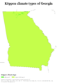
Köppen climate classification types of Georgia.
-
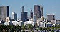
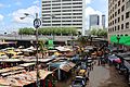
Downtown Atlanta's skyline.
-
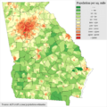
Population density by census tract in Georgia, 2018.
-
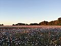
A cotton field in southern Georgia.
-
Filming of Captain America: Civil War in Atlanta, 2015.
-
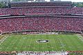
Kickoff at Sanford Stadium in Athens.
-
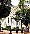
One of the entrances to the University of Georgia.
-

The CNN Center in Atlanta.
-
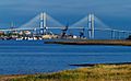
The Port of Brunswick and the Sidney Lanier Bridge.
-
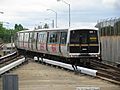
A MARTA (rapid transit) train.
-
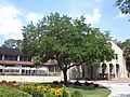
Quercus virginiana (Live oak), the state tree, at Valdosta State University.


.jpg)


,_Sanford_Stadium,_September_2007.jpg)


See also
 In Spanish: Georgia (Estados Unidos) para niños
