
Atlanta metropolitan area facts for kids
Quick facts for kids
Metro Atlanta
Atlanta metropolitan area
|
|
|---|---|

Map of Metro Atlanta
|
|
| Country | United States |
| State | Georgia |
| Largest city | Atlanta |
| Area | |
| • Metro | 8,376 sq mi (21,694 km2) |
| • CSA | 10,494.03 sq mi (27,179.4 km2) |
| Elevation | 606 - 3,288 ft (185 - 1,002 m) |
| Population
(2012 Estimates)
|
|
| • Density | 630/sq mi (243/km2) |
| • Urban | 4,515,419 (9th) |
| • MSA | 5,457,831 (9th) |
| • CSA | 6,092,295 (11th) |
| Time zone | UTC-5 (EST) |
| • Summer (DST) | UTC-4 (EDT) |
| ZIP codes |
300xx to 303xx
|
| Area code(s) | 404, 770, 678, 470 |
The Atlanta metropolitan area is a large region surrounding the city of Atlanta. It is often called Metro Atlanta for short. This area is the biggest metro area in the state of Georgia. It is also the ninth largest metro area in the entire United States.
The U.S. Office of Management and Budget officially calls this area the "Atlanta-Sandy Springs-Roswell, GA Metropolitan Statistical Area". In 2012, about 5.4 million people lived here.
Contents
What is Metro Atlanta?
Metro Atlanta is a large urban area. It includes the main city of Atlanta and many smaller cities and towns around it. This big region helps connect people and businesses.
Where is Metro Atlanta located?
Metro Atlanta is located in the northern part of Georgia. It covers 29 different counties. This means it's a very wide area.
How many people live in Metro Atlanta?
In 2012, the U.S. Census Bureau estimated that over 5.4 million people lived in Metro Atlanta. This makes it a very populated place. It's one of the largest metro areas in the country.
Images for kids
-
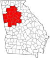
Location in Georgia (MSA counties in red)
-
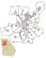
Atlanta suburbs and surrounding cities map.


See also
 In Spanish: Área metropolitana de Atlanta para niños
