
South Carolina facts for kids
Quick facts for kids
South Carolina
|
|||
|---|---|---|---|
|
|||
| Nickname(s):
The Palmetto State
|
|||
| Motto(s): | |||
| Anthem: "Carolina" "South Carolina on my Mind" |
|||

Location of South Carolina within the United States
|
|||
| Country | United States | ||
| Before statehood | Province of South Carolina | ||
| Admitted to the Union | May 23, 1788 (8th state) | ||
| Capital | Columbia | ||
| Largest city | Charleston | ||
| Largest county or equivalent | Greenville | ||
| Largest metro and urban areas | Greenville (combined and metro) Columbia (urban) |
||
| Legislature | General Assembly | ||
| • Upper house | Senate | ||
| • Lower house | House of Representatives | ||
| Judiciary | South Carolina Supreme Court | ||
| U.S. senators | Lindsey Graham (R) Tim Scott (R) |
||
| U.S. House delegation | 6 Republicans 1 Democrat (list) |
||
| Area | |||
| • Total | 32,020.49 sq mi (82,932.7 km2) | ||
| • Land | 30,060.70 sq mi (77,856.9 km2) | ||
| • Water | 1,959.79 sq mi (5,075.8 km2) 6.12% | ||
| Area rank | 40th | ||
| Dimensions | |||
| • Length | 260 mi (420 km) | ||
| • Width | 200 mi (320 km) | ||
| Elevation | 350 ft (110 m) | ||
| Highest elevation | 3,560 ft (1,085 m) | ||
| Lowest elevation
(Atlantic Ocean)
|
0 ft (0 m) | ||
| Population
(2024)
|
|||
| • Total | |||
| • Rank | 23rd | ||
| • Density | 170.27/sq mi (65.74/km2) | ||
| • Density rank | 19th | ||
| • Median household income | $67,800 (2023) | ||
| • Income rank | 41st | ||
| Demonym(s) | South Carolinian | ||
| Language | |||
| • Official language | English | ||
| • Spoken language | |||
| Time zone | UTC−05:00 (Eastern) | ||
| • Summer (DST) | UTC−04:00 (EDT) | ||
| USPS abbreviation |
SC
|
||
| ISO 3166 code | US-SC | ||
| Traditional abbreviation | S.C. | ||
| Latitude | 32°02′ N to 35°13′ N | ||
| Longitude | 78°32′ W to 83°21′ W | ||


| Dance | Carolina shag |
|---|---|
| Bird | Carolina Wren |
| Fish | Striped bass |
| Flower | Yellow jessamine |
| Tree | Sabal palmetto |
| Insect | Carolina mantis |
South Carolina is a state in the Southeastern United States. It shares borders with North Carolina to the north and northeast. To the southeast is the Atlantic Ocean. Georgia is to the west and south, across the Savannah River.
South Carolina is the 40th largest state by land area. It is the 23rd most populated U.S. state. In 2020, its population was 5,118,425 people. The state has 46 counties.
The capital city is Columbia. Its population was 136,632 in 2020. The largest city is Charleston, with 150,227 people in 2020. The Greenville-Spartanburg-Anderson area is the largest combined metropolitan area.
The state was named after King Charles I of England. Carolus is Latin for "Charles." The Province of South Carolina was formed in 1712. It was one of the original Thirteen Colonies. South Carolina became the eighth state to join the United States. This happened on May 23, 1788.
South Carolina was the first state to leave the Union. This happened on December 20, 1860. It rejoined the Union on July 9, 1868, after the American Civil War.
In the 20th century, South Carolina's economy grew. Many textile mills and factories were built. The civil rights movement helped end unfair laws. Today, South Carolina's economy relies on industries like aerospace, farming, car making, and tourism.
South Carolina has three main geographic areas. From east to west, they are the Atlantic coastal plain, the Piedmont, and the Blue Ridge Mountains. The state has a humid subtropical climate. This means hot, humid summers and mild winters.
Contents
History of South Carolina
Early People and Tribes
People have lived in this area for about 12,000 years. When Europeans arrived around 1600, many Native American tribes lived here. The largest tribes were the Cherokee and the Catawba. Their total population was about 20,000.
Tribes like the Siouan people lived along the rivers. The Apalachee, Yuchi, and Yamasee lived near the Savannah River. The Cherokee lived further west. The Catawba lived along the Catawba River. These tribes lived in villages and grew their own food.
Some tribes spent summers on the coast. They gathered oysters and fish. They also grew corn, peas, and beans. In winter, they moved inland to hunt deer and gather nuts. Names like Edisto Island and Kiawah Island come from these tribes.
European Colonization

The Spanish were the first Europeans to arrive in 1521. They built San Miguel de Gualdape in 1526. This was the first European settlement in mainland USA. But it was abandoned within a year.
French settlers tried to build a settlement in 1562. It was at what is now the Charlesfort-Santa Elena site. They left after a fire destroyed their supplies. The Spanish built a fort there later, but also left.
In 1629, King Charles I of England created the Province of Carolina. This area included what is now South Carolina, North Carolina, Georgia, and Tennessee. In the 1670s, English settlers from Barbados came to the area near Charleston.
Settlers built large rice farms called plantations. These were in the South Carolina Lowcountry. Many African people were brought as slaves to work on these farms. By 1720, enslaved people made up most of the population. Another important crop was indigo, used to make blue dye. Eliza Lucas helped develop this crop.
In the Upstate South Carolina, smaller farmers and traders settled. They pushed Native American tribes westward. The colonists wanted more say in their government. In 1719, the colony became a royal colony, directly controlled by the King. In 1729, North Carolina became a separate colony.
South Carolina became very rich. This was thanks to its fertile land and good harbors like Charleston. The colony allowed different religions. Trade in deerskin, lumber, and beef also grew. By the late 1700s, South Carolina was one of the richest of the Thirteen Colonies.
The American Revolution
On March 26, 1776, South Carolina adopted its own Constitution of South Carolina. John Rutledge became the state's first president. In February 1778, South Carolina was the first state to approve the Articles of Confederation. This was the first governing document of the United States. In May 1788, South Carolina approved the United States Constitution. It became the eighth state to join the new country.
During the American Revolutionary War (1775–1783), many battles happened in South Carolina. More than 200 battles and fights took place there. The state was invaded by British forces. There was also a civil war between loyalists (who supported Britain) and patriots (who supported independence). This fighting greatly damaged the countryside.
Before the Civil War

In the time before the Civil War, South Carolina's economy and population grew. Cotton became a very important crop. This was after the invention of the cotton gin.
From 1790 to 1865, wealthy male landowners mostly controlled South Carolina. For example, to be in the State House of Representatives, a man needed a lot of land and enslaved people.
Columbia became the new state capital in 1790. It was built in the center of the state. The town grew after a canal connected it to Charleston in 1800.
In the 1820s, John C. Calhoun became a leader for states' rights. He believed states should have more power than the federal government. In 1832, South Carolina declared that federal tax laws were unfair. This led to the Nullification Crisis. The federal government passed a law to use military force if needed. South Carolina then followed federal law.
In the 1860 presidential election, voting was divided. The Southern states voted for Southern Democrats. The Northern states voted for Abraham Lincoln's Republican Party. Lincoln was against slavery. He did not believe states could leave the Union. Southern leaders thought Lincoln's election would harm their economy, which relied on slavery.
Lincoln was elected president on November 6, 1860. South Carolina quickly declared it was leaving the United States. It was the first state to do so.
The Civil War (1861–1865)

On April 12, 1861, Southern forces began attacking Fort Sumter in Charleston Harbor. This started the American Civil War. In November 1861, Union forces attacked Port Royal Sound. They soon took over Beaufort County and nearby islands. This area became a Union base for the rest of the war.
White plantation owners left their farms. About 10,000 enslaved people were left behind. Northern groups worked with the government to help these people. They ran the cotton farms themselves. This was called the Port Royal Experiment. These workers were paid for the cotton they harvested. They were the first formerly enslaved people freed by the Union to earn wages.
The war badly damaged South Carolina's economy. More than 60,000 men from the state served in the Southern army. Nearly one-third of the white men of fighting age were lost.
In early 1865, General William Tecumseh Sherman's troops marched through the state. They destroyed plantations and much of Columbia.
Reconstruction (1865–1877)
After the war, South Carolina rejoined the United States. This period was called Reconstruction. At first, formerly enslaved people were given some rights. Later, a group of Republicans took control. This group included formerly enslaved people and their allies. They started public schools and welfare programs. They also gave more power to local governments.
In 1871, President Ulysses S. Grant took action to stop violence. He suspended some rights in nine South Carolina counties. This was to stop the Ku Klux Klan from harming African American and white voters. Hundreds of Klansmen were arrested. Many others fled the state.
In the late 1870s, white Democrats used groups like the Red Shirts. These groups used threats and violence against black voters. They took back political control of the state. In 1877, the federal government removed its troops. This ended Reconstruction.
Late 1800s and 1900s
In the 1890s, there was a lot of tension in the state. This was due to racial and economic issues. A group of Republicans and Populists briefly took power. To stop this from happening again, Democrats passed a new constitution in 1895. This constitution made it very hard for most black people and many poor white people to vote. They had to pay a poll tax and pass literacy tests.
By 1896, only 5,500 black voters were registered. But black citizens made up more than 58% of the state's population in 1900. They had almost no political voice in the Jim Crow society.

In the early 1900s, South Carolina's textile industry grew. The state also changed its farming from cotton to other crops. It attracted large military bases. Tourism also became important.
Many African Americans left South Carolina during the 20th century. They moved to Northern, Midwestern, and Western cities for jobs and better lives. This was called the Great Migration. By 1930, white people became the majority in South Carolina for the first time since 1708.
The Civil Rights Movement also took place in South Carolina. South Carolina was one of the states that first rejected the Nineteenth Amendment. This amendment gave women the right to vote in 1920. The state legislature later approved it on July 1, 1969.
Geography of South Carolina


South Carolina has three main geographic areas. From east to west, they are the Atlantic coastal plain, the Piedmont, and the Blue Ridge Mountains. People often call the coastal plain the Low Country. The other two regions are called the Up Country.
The Atlantic Coastal Plain covers two-thirds of the state. Its eastern edge has the Sea Islands. These are a chain of barrier islands. The border between the Low Country and Up Country is the Atlantic Seaboard fall line. This line shows where rivers become too shallow for boats.
The coast has many salt marshes and estuaries. It also has natural ports like Georgetown and Charleston. The coastal plain has many oval-shaped Carolina bays. Their origin is a mystery. The land is flat, with soil made of sand, silt, and clay. Some areas are good for farming, while others are swampy.
West of the coastal plain is the Sandhills region. These hills are old coastal dunes. They formed when the land was lower or the oceans were higher.
The Upstate region has old, worn-down mountains. It is generally hilly with thin, rocky soil. Not much land is good for farming. Many areas that were once farmed are now forests. These forests are part of the Southeastern mixed forests ecoregion. At the edge of the Piedmont is the Atlantic Seaboard fall line. Rivers drop here, providing water power. This power helped cities like Columbia grow.
The northwestern Piedmont is called the Foothills. The Cherokee Parkway is a scenic road here. Table Rock State Park is also in this area.
The highest area is the Blue Ridge Region. It has part of the Blue Ridge Mountains. These mountains continue into North Carolina and Georgia. Sassafras Mountain is South Carolina's highest point, at 3,560 feet (1,085 meters). Caesars Head State Park is also here. The Chattooga River is on the border with Georgia. It is a popular place for whitewater rafting.
Major Lakes in South Carolina

South Carolina has several large lakes. They cover over 683 square miles (1,769 km2). Here are some of the biggest lakes:
- Lake Marion (110,000 acres)
- Lake Strom Thurmond (71,100 acres)
- Lake Moultrie (60,000 acres)
- Lake Hartwell (56,000 acres)
- Lake Murray (50,000 acres)
- Russell Lake (26,650 acres)
- Lake Keowee (18,372 acres)
- Lake Wylie (13,400 acres)
- Lake Wateree (13,250 acres)
- Lake Greenwood (11,400 acres)
- Lake Jocassee (7,500 acres)
- Lake Bowen
Earthquakes in South Carolina
Earthquakes happen most often along the central coast of South Carolina. This is in the Charleston area. South Carolina usually has 10–15 small earthquakes each year. The 1886 Charleston earthquake was the biggest quake ever in the Southeastern United States. This 7.2 magnitude earthquake killed 60 people. It also destroyed much of Charleston.
Climate and Weather

South Carolina has a humid subtropical climate. This means hot, humid summers. Daytime temperatures are usually between 86–93°F (30–34°C). Nights are warm, around 70–75°F (21–24°C) on the coast. Inland, nights are 66–73°F (19–23°C).
Winters are mild, especially near the coast. High temperatures are around 60°F (16°C). Overnight lows are about 40°F (5–8°C). Inland, the average January night temperature is around 32°F (0°C). It can get much colder in the Upstate.
Rain is common all year. The coast gets more rain in summer. Inland, March is usually the wettest month. Winter is the driest season. November is the driest month overall. The highest temperature recorded was 113°F (45°C) in 2012. The lowest was -19°F (-28°C) in 1985.
Snow is not very common in most of the state. Coastal areas get less than an inch (2.5 cm) of snow each year. Some years, they get no snow at all. The interior gets a little more snow. But no part of the state averages more than 12 inches (30 cm) of snow per year. The mountains in the northwest get the most snow. Freezing rain and ice are more common than snow.
South Carolina can also have tropical cyclones and tornadoes.
Hurricanes and Tropical Storms

South Carolina is sometimes hit by tropical cyclones. This is a concern during hurricane season, from June 1 to November 30. The most risky time is from early August to early October. Two strong hurricanes that hit South Carolina were Hurricane Hazel (1954) and Hurricane Hugo (1989). Both were very powerful storms.
The state has about 50 days of thunderstorms each year. It is less likely to have tornadoes than states closer to the Gulf of Mexico. But some notable tornadoes have hit South Carolina. The state averages about 14 tornadoes annually. Hail is common with many thunderstorms. This is because of the difference between warm ground and cold air high up.
Government of South Carolina
South Carolina's government has three parts:
- The executive branch is led by the governor of South Carolina.
- The legislative branch is the South Carolina General Assembly.
- The judicial branch is the South Carolina Supreme Court.
People and Population
| Historical population | |||
|---|---|---|---|
| Census | Pop. | %± | |
| 1790 | 249,073 | — | |
| 1800 | 345,591 | 38.8% | |
| 1810 | 415,115 | 20.1% | |
| 1820 | 502,741 | 21.1% | |
| 1830 | 581,185 | 15.6% | |
| 1840 | 594,398 | 2.3% | |
| 1850 | 668,507 | 12.5% | |
| 1860 | 703,708 | 5.3% | |
| 1870 | 705,606 | 0.3% | |
| 1880 | 995,577 | 41.1% | |
| 1890 | 1,151,149 | 15.6% | |
| 1900 | 1,340,316 | 16.4% | |
| 1910 | 1,515,400 | 13.1% | |
| 1920 | 1,683,724 | 11.1% | |
| 1930 | 1,738,765 | 3.3% | |
| 1940 | 1,899,804 | 9.3% | |
| 1950 | 2,117,027 | 11.4% | |
| 1960 | 2,382,594 | 12.5% | |
| 1970 | 2,590,516 | 8.7% | |
| 1980 | 3,121,820 | 20.5% | |
| 1990 | 3,486,703 | 11.7% | |
| 2000 | 4,012,012 | 15.1% | |
| 2010 | 4,625,364 | 15.3% | |
| 2020 | 5,118,425 | 10.7% | |
| Source: 1910–2020 | |||
| Race and ethnicity | Alone | Total | ||
|---|---|---|---|---|
| White (non-Hispanic) | 62.1% |
|
65.5% |
|
| African American (non-Hispanic) | 24.8% |
|
26.3% |
|
| Hispanic or Latino | — | 6.9% |
|
|
| Asian | 1.7% |
|
2.3% |
|
| Native American | 0.3% |
|
1.8% |
|
| Pacific Islander | 0.1% |
|
0.1% |
|
| Other | 0.4% |
|
1.0% |
|
| Racial composition | 1990 | 2000 | 2010 |
|---|---|---|---|
| White | 69.0% | 67.2% | 66.2% |
| Black | 29.8% | 29.5% | 27.9% |
| Asian | 0.6% | 0.9% | 1.3% |
| Native American | 0.2% | 0.3% | 0.4% |
| Native Hawaiian and other Pacific Islander |
– | – | 0.1% |
| Two or more races | – | 1.0% | 1.7% |

In 2020, South Carolina's population was 5,118,425. The population grew by 11.31% since 2010. People moving into the state from other countries added 36,401 people. People moving from other U.S. states added 115,084 people.
Between 2000 and 2005, South Carolina's foreign-born population grew faster than any other state. South Carolina does not allow "sanctuary cities." These are cities that limit cooperation with federal immigration laws.
| African American |
| European American |
| Other |
Historical South Carolina racial breakdown of population
Religion in South Carolina
Religion in South Carolina Evangelical Protestant (35%) Mainline Protestant (16%) Historically Black Protestant (15%) Catholic (10%) Other Christian (2%) Other (2%) Unaffiliated ("none") (19%) Don't Know (1%)
Christianity is the largest religion in South Carolina. In 2010, the biggest Christian groups were the Southern Baptist Convention and the United Methodist Church. The Roman Catholic Church was also very large.
The African Methodist Episcopal Church and the Presbyterian Church (USA) also have many members. South Carolina has the highest number of people who follow the Baháʼí Faith per person in the U.S.
Economy and Infrastructure
.jpg)
In 2019, South Carolina's economy was worth $249.9 billion. This made it the 26th largest economy among U.S. states. The state's economy has grown over the years.
Important industries include textiles, chemicals, paper, machinery, and cars. Tourism is also a big part of the economy. Major farm products are tobacco, poultry, cotton, and dairy.
Many large companies have moved to South Carolina. Boeing opened a factory in Charleston in 2011. It builds the 787 Dreamliner airplane. South Carolina is a "right-to-work" state. This means workers don't have to join a union to get or keep a job.
Foreign companies also invest in South Carolina. There are 1,950 foreign-owned businesses here. They employ almost 135,000 people. Since 1994, BMW has had a factory near Greer. The Zapp Group has operated near Charleston since 1996.
Media in South Carolina
South Carolina has 36 TV stations. These include PBS channels. They serve cities like Columbia, Florence, and Charleston.
Transportation in South Carolina
Roads
South Carolina has the fourth largest state-maintained road system in the country. It includes 11 Interstates, numbered highways, and state highways. There are also many secondary roads. In total, there are about 41,500 miles of roads.
Secondary roads have a special numbering system. The first number shows the county. The second number is unique to that road.
Rail Travel
Amtrak runs four passenger train routes in South Carolina. These are the Crescent, Palmetto, Silver Meteor, and Silver Star. The Crescent serves cities in the Upstate. The Silver Star serves cities in the Midlands. The Palmetto and Silver Meteor serve cities in the Lowcountry.
Train Stations
| Station | Connections |
|---|---|
| Camden |
Silver Star
|
| North Charleston |
Palmetto
Silver Meteor
|
| Columbia |
Silver Star
|
| Clemson |
Crescent
|
| Denmark |
Silver Star
|
| Dillon |
Palmetto
|
| Florence |
Palmetto
Silver Meteor
|
| Greenville |
Crescent
|
| Kingstree |
Palmetto
Silver Meteor
|
| Spartanburg |
Crescent
|
| Yemassee |
Palmetto
Silver Meteor
|
Freight Rail
CSX Transportation and Norfolk Southern are the main freight train companies in South Carolina. Other smaller companies also operate in the state.
Airports in South Carolina
South Carolina has seven important airports. They all serve as regional hubs. Charleston International Airport is the busiest for passengers. Charlotte/Douglas International Airport in North Carolina is also nearby. It is one of the busiest airports in the world.
- Columbia Metropolitan Airport – Columbia
- Charleston International Airport – North Charleston
- Greenville-Spartanburg International Airport – Greenville/Spartanburg
- Florence Regional Airport – Florence
- Myrtle Beach International Airport – Myrtle Beach
- Hilton Head Airport – Hilton Head Island/Beaufort
- Rock Hill/York County Airport – Rock Hill
Federal Lands in South Carolina

South Carolina has several national parks and historic sites. It also has military bases.
- Charles Pinckney National Historic Site at Mt. Pleasant
- Congaree National Park in Hopkins
- Cowpens National Battlefield near Chesnee
- Fort Moultrie National Monument at Sullivan's Island
- Fort Sumter National Monument in Charleston Harbor
- Kings Mountain National Military Park at Blacksburg
- Ninety Six National Historic Site in Ninety Six
- Overmountain Victory National Historic Trail
- Fort Jackson near Columbia
- Joint Base Charleston near Charleston
- Shaw Air Force Base near Sumter
Education in South Carolina
In 2014, the South Carolina Supreme Court ruled that the state was not providing a good enough education. This was for children in all parts of the state.
South Carolina has 1,144 schools for grades K-12. These schools are in 85 school districts. In 2009, 712,244 students were enrolled. In 2008–2009, South Carolina spent $9,450 per student. This placed it 31st in the country for spending per student.
In 2015, the average SAT score in South Carolina was 1442. This was 48 points lower than the national average of 1490.
South Carolina is the only state that owns and runs its own school bus system. In 2016, the state had 5,582 buses. The average bus was 15 years old. The national average is six years old. Some buses were even 30 years old. In 2017, the state planned to buy 1,000 new buses.
Colleges and Universities
South Carolina has many different colleges and universities. Some are large state research universities. Others are smaller colleges focused on arts, religion, or military training.
- The College of Charleston was founded in 1770. It is the oldest college in South Carolina. It is also the 13th oldest in the United States. Its campus is part of Charleston's historic downtown.
- The University of South Carolina in Columbia was founded in 1801. It is a large public research university. It has seven smaller campuses. Its main campus is near the South Carolina State House. About 35,000 students attend the Columbia campus.

- Furman University is a private university in Greenville. It was founded in 1826. It focuses on undergraduate education. It is the largest private college in South Carolina.
- Erskine College is a private college in Due West, South Carolina. It was founded in 1839. It is connected to the Associate Reformed Presbyterian Church.
- The Citadel, The Military College of South Carolina in Charleston was founded in 1842. It is known for its military program for students. It also offers evening programs for non-military students.
- Wofford College is a small college in Spartanburg. It was founded in 1854. It is one of the few colleges in the Southeast that still uses its original campus from before the Civil War.
- Newberry College is a small college in Newberry. It was founded in 1856. It is a private college of the Evangelical Lutheran Church in America.
- Claflin University was founded in 1869. It is the oldest historically black college in the state.
- Lander University is a public university in Greenwood. It was founded in 1872 as a women's college. It became a co-ed public university in 1973.
- Presbyterian College (PC) is a private college founded in 1880 in Clinton. It has about 1,000 undergraduate students.
- Winthrop University was founded in 1886 in Rock Hill. It started as a school for women teachers. It became a co-ed public university in 1974.
- Clemson University was founded in 1889. It is a public research university in Clemson. It has over 19,000 undergraduate students. It is also home to the South Carolina Botanical Garden.
- North Greenville University was founded in 1891. It is a university in Tigerville. It is connected to the Southern Baptist Convention.
- South Carolina State University was founded in 1896. It is a historically black university in Orangeburg. It offers many types of degrees.
- Anderson University was founded in 1911. It offers bachelor's and master's degrees.
- Webster University was founded in 1915. It has five campuses in South Carolina.
- Bob Jones University was founded in 1927. It is a private Christian university.
- Coastal Carolina University was founded in 1954. It became an independent university in 1993. It is in Conway, near Myrtle Beach.
- Charleston Southern University was founded in 1969. It is a private university in North Charleston. It is connected to the South Carolina Baptist Convention.
- Francis Marion University is a state-supported university near Florence, South Carolina. It was founded in 1970.
Universities and Colleges by Endowment (2010)
| State rank |
National rank |
Institution | Location | Public / private? | Endowment funds | Percentage change YOY |
|---|---|---|---|---|---|---|
| 1 | 142 | Furman University | Greenville | Private | $650,000,000 | 7.8% |
| 2 | 151 | University of South Carolina | Columbia & regional campuses |
Public | $625,186,000 | 6.0% |
| 3 | 153 | Clemson University | Clemson | Public | $623,200,000 | 9.5% |
| 4 | 236 | Medical University of South Carolina | Charleston | Public | $272,319,000 | 13.7% |
| 5 | 270 | The Citadel | Charleston | Public | $244,000,000 | 8.1% |
| 6 | 324 | Wofford College | Spartanburg | Private | $166,619,000 | 10.2% |
| 7 | 447 | Presbyterian College | Clinton | Private | $97,590,000 | 11.0% |
| 8 | 530 | Converse College | Spartanburg | Private | $78,240,004 | 6.4% |
| 9 | 782 | Winthrop University | Rock Hill | Public | $43,600,000 | 13.6% |
| 10 | 658 | Coker College | Hartsville | Private | $37,660,000 | 4.9% |
Images for kids
-
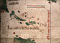
A map from 1502 showing the shores of Florida and the future Carolina.
-
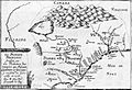
A map of French Florida, which included parts of modern-day South Carolina.
-
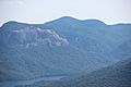
Pinnacle Mountain as seen from Caesars Head.
-
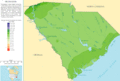
A map showing the average yearly rainfall in South Carolina.
-
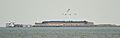
Fort Sumter National Monument in Charleston harbor. This is where the American Civil War began in 1861.
-
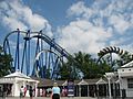
A roller coaster at Carowinds, which is partly in South Carolina.
-
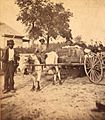
A cotton farmer and his children. They are taking their cotton to a gin around 1870.
-
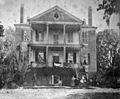
Arcadia Plantation in Georgetown County, around 1893.
-

People walking on the beach at Myrtle Beach.
-
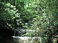
A waterfall on Carrick Creek Nature Trail, in Table Rock State Park.
-

A trail in Harbison State Forest during winter.
-
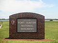
The sign for Fort Sumter. You need a ferry ride to get there.
-
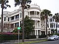
An old home on "The Battery" in Charleston, South Carolina.
-
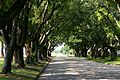
Live oaks overhanging streets in Georgetown, South Carolina.
-
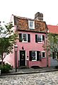
The Pink House, the oldest stone building in Charleston.
-
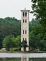
The bell tower at Furman University near Greenville.
,_1501-02_(bibl._estense)_02.jpg)

_viewed_from_Caesars_Head,_June_2019.jpg)


See also
 In Spanish: Carolina del Sur para niños
