
Clemson, South Carolina facts for kids
Quick facts for kids
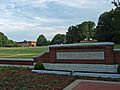
Clemson
|
||
|---|---|---|

Top, left to right: Tillman Hall (near Clemson City), Hanover House, Fort Hill, Memorial Stadium, College Avenue
|
||
|
||
| Nickname(s):
South Knoxville
|
||
| Motto(s):
"In season, every season."
|
||

Location of Clemson, South Carolina
|
||

Clemson
Location in South Carolina

Clemson
Location in the United States
|
||
| Country | United States | |
| State | South Carolina | |
| Counties | Pickens, Anderson | |
| Area | ||
| • City | 8.15 sq mi (21.11 km2) | |
| • Land | 7.69 sq mi (19.92 km2) | |
| • Water | 0.46 sq mi (1.19 km2) | |
| Elevation | 725 ft (221 m) | |
| Population
(2020)
|
||
| • City | 17,681 | |
| • Density | 2,298.62/sq mi (887.54/km2) | |
| • Urban | 118,369 (US: 286th) | |
| • Urban density | 1,233.8/sq mi (476.4/km2) | |
| Time zone | UTC−5 (Eastern (EST)) | |
| • Summer (DST) | UTC−4 (EDT) | |
| ZIP codes |
29631-29634
|
|
| Area codes | 864, 821 | |
| FIPS code | 45-14950 | |
| GNIS feature ID | 1247312 | |

Clemson (/ˈklɛmpsən, ˈklɛmzən/) is a city in Pickens and Anderson counties in the state of South Carolina. It is right next to Clemson University. The city and the university are very closely connected. In 2015, the Princeton Review said Clemson was the best in the U.S. for how well the town and its university get along. In 2020, about 17,681 people lived in Clemson.
Clemson is part of a larger area called the Greenville-Anderson-Greer Metropolitan Area.
Contents
History

People from Europe started settling here after the Cherokee people had to give up their land in 1819. The Cherokee had lived in this area for a long time. They had seven towns along the Keowee River. Later, most of them were forced to move far away in 1839 to a place called Indian Territory (which is now Oklahoma).
The community was first called Calhoun. Clemson University was started in 1889 right next to the town. It grew into a big public university that is a main part of the town. The university campus is south of the original town. In 1943, the town was renamed Clemson to show its strong link with the university. The small downtown area has shops, restaurants, and some homes.
The university has dorms for students, but many students live in apartments around the city. Outside of downtown, there are not many sidewalks, but some streets have bike paths. The city wants to protect its old buildings and history.
The Clemson train station, built in 1893, was updated in 2001. It now holds the local chamber of commerce and a visitor center. It was closed for a short time in 2016 for road work but opened again in 2019. A main road, U.S. Route 123, runs along the north side of the city. This area has many modern shopping centers.
How Clemson University Started
Clemson University began as an agricultural college in 1889. It was built on land that used to be the Fort Hill Plantation. This plantation belonged to a famous statesman named John C. Calhoun. He got the land through his marriage. His wife, Floride, inherited the property from her mother.
John C. Calhoun and Floride had a daughter named Anna Maria. When she was 21, she married Thomas Green Clemson. After her father died in 1850, her mother Floride owned Fort Hill Plantation completely.
Anna Maria was their only child who lived. So, when her mother Floride died in 1866, Anna Maria inherited part of Fort Hill. Anna Maria wanted the land to be used for an agricultural college. When she died in 1875, Thomas Green Clemson inherited the plantation. He made sure her wish came true. After he died in 1888, Clemson University was founded on that land.
Geography
.jpg)
Clemson is located about 27 miles (43 km) west of Greenville and 15 miles (24 km) north of Anderson. The city is in the northwest part of South Carolina, in the foothills of the Blue Ridge Mountains. It is also on the edge of Lake Hartwell.
The city covers about 8.15 square miles (21.11 km²). Most of this is land, and a small part is water.
Climate
Clemson has a humid subtropical climate. This means it has hot, humid summers and cool winters. It rains a good amount throughout the year. The most rain usually falls in August and February. Snowfall is not very common, with only about 2.2 inches (5.6 cm) of snow each winter.
| Climate data for Clemson University, South Carolina (1991–2020 normals, extremes 1896–present) | |||||||||||||
|---|---|---|---|---|---|---|---|---|---|---|---|---|---|
| Month | Jan | Feb | Mar | Apr | May | Jun | Jul | Aug | Sep | Oct | Nov | Dec | Year |
| Record high °F (°C) | 80 (27) |
82 (28) |
89 (32) |
93 (34) |
100 (38) |
105 (41) |
106 (41) |
104 (40) |
104 (40) |
98 (37) |
86 (30) |
81 (27) |
106 (41) |
| Mean daily maximum °F (°C) | 53.4 (11.9) |
57.1 (13.9) |
64.6 (18.1) |
73.3 (22.9) |
80.6 (27.0) |
87.6 (30.9) |
91.0 (32.8) |
89.5 (31.9) |
84.2 (29.0) |
74.3 (23.5) |
64.3 (17.9) |
55.9 (13.3) |
73.0 (22.8) |
| Daily mean °F (°C) | 42.9 (6.1) |
45.8 (7.7) |
52.6 (11.4) |
60.8 (16.0) |
68.9 (20.5) |
76.4 (24.7) |
79.8 (26.6) |
78.6 (25.9) |
73.0 (22.8) |
62.2 (16.8) |
51.9 (11.1) |
45.1 (7.3) |
61.5 (16.4) |
| Mean daily minimum °F (°C) | 32.5 (0.3) |
34.6 (1.4) |
40.6 (4.8) |
48.2 (9.0) |
57.2 (14.0) |
65.1 (18.4) |
68.5 (20.3) |
67.7 (19.8) |
61.9 (16.6) |
50.0 (10.0) |
39.5 (4.2) |
34.4 (1.3) |
50.0 (10.0) |
| Record low °F (°C) | −5 (−21) |
−7 (−22) |
4 (−16) |
24 (−4) |
32 (0) |
42 (6) |
49 (9) |
52 (11) |
34 (1) |
23 (−5) |
10 (−12) |
2 (−17) |
−7 (−22) |
| Average precipitation inches (mm) | 4.94 (125) |
4.36 (111) |
4.80 (122) |
4.20 (107) |
4.06 (103) |
4.16 (106) |
4.09 (104) |
5.27 (134) |
3.80 (97) |
3.76 (96) |
3.87 (98) |
5.07 (129) |
52.38 (1,330) |
| Average snowfall inches (cm) | 0.8 (2.0) |
0.8 (2.0) |
0.3 (0.76) |
0.0 (0.0) |
0.0 (0.0) |
0.0 (0.0) |
0.0 (0.0) |
0.0 (0.0) |
0.0 (0.0) |
0.0 (0.0) |
0.0 (0.0) |
0.3 (0.76) |
2.2 (5.6) |
| Average precipitation days (≥ 0.01 in) | 10.6 | 10.5 | 10.7 | 9.7 | 9.7 | 11.1 | 10.4 | 10.8 | 8.3 | 7.7 | 9.2 | 11.3 | 120.0 |
| Average snowy days (≥ 0.1 in) | 0.4 | 0.5 | 0.1 | 0.0 | 0.0 | 0.0 | 0.0 | 0.0 | 0.0 | 0.0 | 0.0 | 0.4 | 1.4 |
| Source: NOAA | |||||||||||||
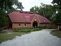
Historic Places
Many important places and buildings in Clemson are listed on the National Register of Historic Places. This means they are special and protected because of their history.
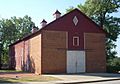
Here are some places in Clemson City on the list:
- J. C. Stribling Barn
- Old Stone Church and Cemetery
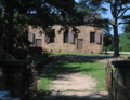
Here are some places on the Clemson University campus on the list:
- Clemson University Historic District I and II
- Clemson College Sheep Barn
- Fort Hill (John C. Calhoun Mansion and Library)
- Hanover House
Other places with Clemson addresses:
- Hopewell Plantation - Gen. Andrew Pickens' Home
-
J. C. Stribling Barn (Clemson City)
-
Old Stone Church and Cemetery (Clemson City)
-
Clemson College Sheep Barn
-
Bowman Field and Sikes Hall of the Clemson University Historic District I
-
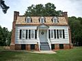
Hanover House (Clemson University)
-
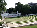
Amphitheater of the Clemson University Historic District II
.JPG)

.JPG)

.JPG)

Fun Places to Visit
Clemson University has some cool places to visit. These include the South Carolina Botanical Garden, Fort Hill Plantation, and the Bob Campbell Geology Museum. Lake Hartwell, a big lake, is a popular spot for outdoor fun and is right next to the city. The beautiful Blue Ridge Mountains are also only about 30 miles (48 km) away.
-
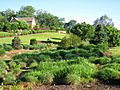
South Carolina Botanical Garden


Population
| Historical population | |||
|---|---|---|---|
| Census | Pop. | %± | |
| 1940 | 761 | — | |
| 1950 | 1,204 | 58.2% | |
| 1960 | 1,587 | 31.8% | |
| 1970 | 6,690 | 321.6% | |
| 1980 | 8,118 | 21.3% | |
| 1990 | 11,096 | 36.7% | |
| 2000 | 11,939 | 7.6% | |
| 2010 | 13,905 | 16.5% | |
| 2020 | 17,673 | 27.1% | |
| 2022 (est.) | 17,834 | 28.3% | |
| U.S. Decennial Census | |||

In 2010, Clemson had about 14,089 people. The population grew to 17,681 by 2020. Most people in Clemson are white (about 75%). There are also many Black or African American people (about 7%) and Asian people (about 8.5%). About 4.5% of the population is Hispanic or Latino.
Getting Around

Clemson Area Transit (CAT) is a free bus service in Clemson. It also goes to nearby towns like Anderson, Pendleton, and Seneca. All CAT buses are easy to use for people with disabilities. You can even transfer to other local buses in Anderson for free.
Clemson also has an Amtrak train station. The Crescent train route stops here. This train travels all the way from New Orleans to New York City.
There are three major airports near Clemson. The closest is Greenville-Spartanburg International Airport, which is about 45 minutes away. Hartsfield-Jackson Atlanta International Airport in Atlanta, Georgia and Charlotte-Douglas International Airport in Charlotte, North Carolina are both about two and a half hours away. You can find many shuttle services to take you to and from these airports.
Education
Schools for Kids
If you live in the Pickens County part of Clemson, you would go to schools in the Pickens County School District. Students usually attend Clemson Elementary School, RC Edwards Middle School, and D.W. Daniel High School.
Clemson Elementary School used to be called Calhoun-Clemson School. The original building burned down in 1964, but it was rebuilt. It's now on Berkeley Drive. The school colors are orange and blue, and their mascot is a tiger cub.
RC Edwards Middle School opened in 1971. It's named after a past president of Clemson University. It teaches students in sixth, seventh, and eighth grades. The school colors are purple and white, and their mascot is the panther.
The current D.W. Daniel High School was built in 2010. It's named after David Wistar Daniel, a professor who cared a lot about public schools. The school is known for its strong football team. Its colors are blue and gold, and the mascot is the lion.
If you live in the Anderson County part of Clemson, you would go to schools in Anderson School District 4.
Colleges and Universities
Clemson is right next to Clemson University. The city and the university are very close. In 2015, the Princeton Review said that Clemson was the best place in the U.S. for how well the town and its university work together.
Even though the university is right next to the city, it's not officially inside the city limits. This means Clemson University has its own rules and doesn't always need permission from the city government for its projects. The state of South Carolina gave Clemson University special status in 1894.
See also
 In Spanish: Clemson (Carolina del Sur) para niños
