Barrier island facts for kids
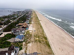
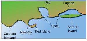
Barrier islands are long, narrow islands made of sand. They form in the ocean, running parallel to the mainland coast. Think of them like a natural wall of sand built by ocean waves and tides.
These islands usually appear in groups, forming a chain of many islands. They are always changing, especially during storms. But this change is good! Barrier islands absorb the energy from waves and storms, protecting the mainland coast. They also create calm, protected water areas where wetlands can grow and thrive.
A chain of barrier islands can stretch for hundreds of kilometers. They are often separated by narrow channels of water called tidal inlets. Sometimes, an inlet might close permanently. When this happens, an island can connect to the mainland, becoming a barrier peninsula or a barrier beach.
The size and shape of barrier islands depend on many things. These include how big the tides are, how strong the waves are, how much sand is available, and how the sea level is changing. The amount of plants growing on an island also affects its height and how it changes over time.
About 13-15% of the world's coastlines have chains of barrier islands. They form in different places, showing that they can grow and survive in many types of environments. Scientists have several ideas about how they form.
Humans can also build structures similar to barrier islands called breakwaters. These are built parallel to the shore to reduce wave energy and protect the coast. They are an important part of coastal engineering.
Contents
Parts of a Barrier Island
Barrier islands have different parts, each shaped by the ocean, wind, or calm waters behind the island.
- Upper shoreface
This is where the ocean water first meets the island. It's the part of the island facing the open ocean. Here, you find fine sand mixed with mud. Further out, the sand gets even finer. Waves are weaker here because the water is deeper. Many old fossils can be found in these areas.
- Middle shoreface
This part is closer to the shore than the upper shoreface. Strong waves affect this area a lot. The sand here is medium-sized, and you might find pieces of shells. Because of the strong wave action, it's harder for living things to disturb the sand here.
- Lower shoreface
This area is always affected by waves. The constant movement of waves creates special patterns in the sand, like a herringbone design. The sand here is coarser, meaning it has bigger grains.
- Foreshore
The foreshore is the sandy area on the land between where the water is highest (high tide) and lowest (low tide). Like the upper shoreface, waves constantly hit this area. You can see layers and slanted patterns in the sand. The sand is coarser because of the strong wave energy. It's also very well sorted, meaning the sand grains are all about the same size.
- Backshore
The backshore is always above the highest water level. A small ridge called a berm often marks the line between the foreshore and backshore. Wind is the main force here, not water. However, during big storms, strong waves and wind can move sand onto or away from the backshore.
- Dunes
Coastal dunes are hills of sand created by the wind. They are usually found at the top of the backshore. These dunes look like typical wind-blown sand dunes. But on a barrier island, they often have roots from coastal plants and signs of marine life.
- Lagoon and tidal flats
This area is located behind the dunes and backshore, on the side facing the mainland. The water here is calm, allowing fine silts, sands, and mud to settle. Lagoons can sometimes have very little oxygen, which helps a lot of organic-rich mud to form. Many plants also grow in these calm waters.
Where to Find Barrier Islands
Barrier islands exist on every continent except Antarctica. They are mostly found in places where the Earth's tectonic plates are stable. This includes coasts that are moving away from ocean ridges and around smaller seas like the Mediterranean Sea and the Gulf of Mexico. Barrier islands form best in areas with small tides and plenty of sand.
Australia
Moreton Bay in eastern Australia is protected by a chain of very large barrier islands. From north to south, these are Bribie Island, Moreton Island, North Stradbroke Island, and South Stradbroke Island. North Stradbroke Island is the second largest sand island in the world, and Moreton Island is the third largest.
Fraser Island, located north of Moreton Bay, is the largest sand island in the world.
United States
Barrier islands are very common along the East and Gulf Coasts of the United States. Every state from Maine to Florida and from Florida to Texas has at least part of a barrier island. Florida alone has many, including Sanibel and Captiva Islands on the Gulf Coast. Padre Island in Texas is the longest barrier island in the world.
On the East Coast, famous barrier islands include Miami Beach in Florida, Hatteras Island in North Carolina, and Assateague Island in Virginia and Maryland. Atlantic City is on Absecon Island in New Jersey. You won't find barrier islands on the Pacific Coast of the U.S. because of its rocky shore. However, barrier peninsulas can be found there.
Canada
Barrier islands are also found in Maritime Canada. For example, at Miramichi Bay, New Brunswick, islands like Portage Island and Fox Island protect the inner bay from storms.
Mexico
Mexico's Gulf of Mexico coast also has many barrier islands and peninsulas.
New Zealand
Barrier islands are more common in the northern parts of New Zealand's main islands. Examples include Matakana Island, which protects Tauranga Harbour, and Rabbit Island in Tasman Bay. The Boulder Bank near Nelson is a unique rocky structure that acts like a barrier.
India
The Vypin Island on the southwest coast of India in Kerala is 27 km long. It is one of the most crowded islands in the world.
Indonesia
The Indonesian Barrier Islands are off the western coast of Sumatra. These include Simeulue, the Banyak Islands, Nias, the Batu Islands, the Mentawai Islands, and Enggano Island.
Europe
You can see barrier islands in the Baltic Sea, from Poland to Lithuania. They are also clearly visible in the Wadden Islands, which stretch from the Netherlands to Denmark. Lido di Venezia and Pellestrina are important barrier islands that have protected the city of Venice in Italy for centuries. Chesil Beach in England is another example of a barrier beach.
How Barrier Islands Change
Migration and overwash
During big storms, ocean water levels can rise higher than the island. This can cause "overwash," where sand is carried from the front of the island over its top and to the landward side. This process helps the barrier island move and change over time.
Critical width concept
Scientists have studied how wide barrier islands need to be to survive. The "critical width concept" means that if an island is too narrow, overwash will move sand across it, helping it keep its shape and not shrink. If an island is wider than this "critical width," it might get narrower until it reaches that ideal width. This idea is important for projects that rebuild barrier islands to protect bays and mainland beaches.
How Barrier Islands Form
Scientists have thought about how barrier islands form for over 150 years. There are three main ideas: the offshore bar theory, the spit accretion theory, and the submergence theory. No single idea explains how all barrier islands form, as they are found all over the world. Scientists now believe that barrier islands can form in several different ways.
Some general conditions are needed for barrier islands to form. They grow best on coasts where waves are strong and tides are small to medium. They are less common where tides are very large. Also, the seafloor near the coast needs to be gently sloping. If it's too steep, sand won't build up into a bar.
A large supply of sand is also needed. This sand often comes from rivers or glaciers. Finally, the sea level needs to be stable. If the sea level changes too quickly, waves won't have enough time to gather sand and build up the island.
Offshore bar theory
In 1845, a French scientist named Elie de Beaumont suggested this idea. He thought that waves moving into shallow water stirred up sand. When the waves broke and lost their energy, this sand was dropped, forming a sandbar underwater. Over time, these sandbars grew taller and eventually rose above the sea, becoming barrier islands.
Some barrier islands along the Gulf Coast of Florida have been seen forming this way, like Anclote Key and Shell Key.
Spit accretion theory
In 1885, American geologist Grove Karl Gilbert proposed a different idea. He believed that sand moved along the coast by waves and currents. This sand would build up long, narrow strips of land called spits that stretched out from headlands (points of land) parallel to the coast. Later, big storms could break through these spits, creating barrier islands.
Submergence theory
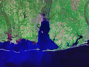
In 1890, William John McGee suggested that the East and Gulf coasts of the United States were sinking. He noticed many "drowned" river valleys along these coasts, like Chesapeake Bay. He thought that as the land sank, coastal ridges became separated from the mainland, and lagoons formed behind them. He used the Mississippi–Alabama barrier islands as an example. However, later studies showed that his explanation for these specific islands was not quite right.
Along the coast of Louisiana, old parts of the Mississippi River delta have been reshaped by waves, forming beach ridges. As the marshes behind these barriers slowly sink, they turn into open water. For example, between 1853 and 1978, two small bays behind the Isles Dernieres barrier islands grew into a large body of water called Lake Pelto, causing the islands to separate from the mainland.
Boulder Bank
In New Zealand, there's a unique natural structure called the Boulder Bank at the entrance to Nelson Haven. It's a 13 km long stretch of rocks, not sand, and it's connected to the mainland at one end. Scientists are still debating how this strange structure formed, but the idea of longshore drift (sand/rock moving along the coast) is the most accepted. Studies have shown that the rocks here can move about 7.5 meters a year.
Types of Barrier Islands
Richard Davis describes two main types of barrier islands: wave-dominated and mixed-energy.
Wave-dominated
Wave-dominated barrier islands are long, low, and narrow. They usually have unstable inlets at each end. Waves hitting the island at an angle create currents that move sand along the shore, making the island longer. These currents usually flow in one direction, but sometimes they can flow towards both ends of the island.
After storms, sand often washes over the island to the lagoon side. This is common on younger barrier islands. Strong storms can also break through these islands, creating new inlets. These new inlets might close later if enough sand is carried into them. Older barrier islands with more dunes are better protected from overwash and new inlets.
Wave-dominated islands need a lot of sand to grow and form dunes. If an island doesn't get enough sand, repeated overwashes from storms will cause the island to move closer to the mainland.
Mixed-energy
Wave-dominated barrier islands can sometimes turn into mixed-energy barrier islands. These islands are shaped by both wave energy and the flow of tides. The movement of tidal water carries sand. Sand builds up on both sides of an inlet. On the bay or lagoon side, a "flood delta" forms from sand carried in by the rising tide. On the open ocean side, an "ebb delta" forms from sand carried out by the falling tide.
Large tidal flows create large ebb deltas, which can sometimes be seen at low tide. These ebb deltas can change how waves approach the inlet, sometimes reversing the longshore current. This can cause sand to build up at one end of the island, making it wider and giving it a "drumstick" shape. This process can also stop sand from reaching the island on the other side of the inlet, making that island "starve" for sand.
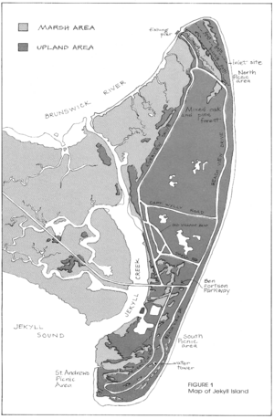
Many of the Sea Islands in Georgia are wide compared to their length. Siesta Key, Florida has a drumstick shape, wider at its northern end.
Why Barrier Islands are Important
Barrier islands are super important for protecting the mainland coast and the water systems behind them from strong ocean waves and storms. They create a special environment of calm, slightly salty water. Because of this, many different wetland systems like lagoons, estuaries, and marshes can form. These areas are rich habitats for many kinds of plants and animals. Without barrier islands, these wetlands wouldn't exist; they would be destroyed by daily ocean waves and tides, as well as big storms. The Louisiana barrier islands are a great example of this protection.
See also
- North Frisian Barrier Island
- Outer Banks
- Virginia Barrier Islands
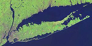
- New York Barrier Islands
- Texas barrier islands
- Sea Islands
- Long Beach Island
- Bald Head Island
 In Spanish: Isla barrera para niños
 | Bayard Rustin |
 | Jeannette Carter |
 | Jeremiah A. Brown |


