
Assateague Island facts for kids

Aerial view of Assateague Island with Ocean City, Maryland in the background
|
|

Assateague Island
Location in Maryland

Assateague Island
Location in Virginia

Assateague Island
Location in the United States
|
|
| Geography | |
|---|---|
| Location | Atlantic Ocean |
| Coordinates | 37°58′35.07″N 75°18′17.12″W / 37.9764083°N 75.3047556°W |
| Area | 63 km2 (24 sq mi) |
| Administration | |
|
United States
|
|
| Additional information | |
| Official website |
|
Assateague Island is a long, narrow island off the coast of the Atlantic Ocean. It is about 37 miles (60 km) long. The island is split between two states: the northern two-thirds are in Maryland, and the southern third is in Virginia.
Assateague Island is famous for its wild horses, beautiful beaches, and the Assateague Lighthouse. It also has many marshes, bays, and coves. You can drive to the island from both Maryland and Virginia. However, there is no road that goes the whole length of the island.
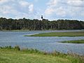
The Maryland part of the island includes most of the Assateague Island National Seashore and Assateague State Park. The Virginia part has the Chincoteague National Wildlife Refuge. It also has a beach area with lifeguards and visitor centers. These are managed by the National Park Service (NPS).
Contents
Island History and Changes
Assateague Island is a barrier island. This means it is a long, narrow island that protects the mainland from ocean storms. Barrier islands are always changing. Their shape is affected by how sand moves in the ocean.
How the Island Changed
Long ago, Assateague Island was connected to another island called Fenwick Island. But a big storm in 1933, called the Chesapeake–Potomac hurricane, created a gap between them. This gap is called an inlet.
Normally, this inlet would have filled back up with sand. But between 1933 and 1935, people built artificial walls called jetties. These jetties kept the inlet open for boats. Because of this, Assateague Island has slowly moved westward. Now, the two islands are about 0.62 miles (1 km) apart. This change helped Ocean City, Maryland, but it caused erosion on Assateague.
Protecting the Island
For many years, people debated what to do with Assateague Island. Some wanted to build on it, while others wanted to protect it. In the 1950s, a road and buildings were planned for the Maryland side.
However, a huge storm in 1962 destroyed most of these plans. After this, Maryland decided to support protecting the island. In 1965, the Assateague Island National Seashore was created. This helped save the island for everyone to enjoy.
Parks and Wildlife Refuges
Assateague Island is managed by three different groups. These are the National Park Service (NPS), Maryland State Parks, and the United States Fish and Wildlife Service.
Maryland's Protected Areas
All the land north of the Maryland-Virginia line is part of the Assateague Island National Seashore. There is also a smaller area called Assateague State Park. The National Seashore was set up in 1965. Its goal is to protect the island and its waters. It also provides fun activities for visitors.
Virginia's Protected Areas
South of the state line in Virginia, most of the island is the Chincoteague National Wildlife Refuge. This refuge was created in 1943. It provides a safe home for birds that travel long distances, especially snow geese. The National Park Service also manages a one-mile stretch of beach and visitor centers here.
Visiting Assateague Island
Assateague Island offers many ways to explore nature. You can drive on certain parts of the island with a special permit. Camping is popular, with sites available in both the National Seashore and Assateague State Park. You can also find backcountry camping spots.
Things to Do
- Camping: Campsites are available by reservation.
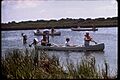
- Kayaking: Paddling on the calm bay side is a great way to see wildlife.
- Off-Road Driving: Certain areas allow off-road vehicles with a permit.
- Pets: Pets are allowed in some parts of the National Seashore and State Park.
- Wildlife Watching: The island is home to many birds and other animals.
Be aware that during summer, there can be many mosquitoes and biting greenhead flies, especially near the bay.
Assateague State Park covers almost 800 acres (3.2 km²) in Maryland. It has 350 campsites, making it the most developed area on the island. Most of the water around the island is part of the National Seashore. The island itself has no people living there permanently.
Island Animals
Assateague Island is a haven for many animals. Over 320 types of birds visit or live on the island each year.
Birdlife
You can see many birds here, like American oystercatchers, great blue herons, and snowy egrets. There are also gulls, terns, and other shorebirds. Raptors and waterfowl are common too. The piping plover, a bird that needs protection, also nests on Assateague.
Wild Horses
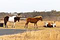
The most famous animals on Assateague Island are its wild horses. In Maryland, they are called Assateague horses. In Virginia, they are known as Chincoteague Ponies. These horses are often smaller than typical horses, but they look like horses. Their small size is likely due to their environment, not their genes.
The horses in Maryland and Virginia are kept separate by a fence. These horses are not truly wild. Their ancestors were once farm animals. A popular story says they came from a Spanish shipwreck. Another idea is that they were colonial horses allowed to roam free. When these horses are adopted by people, they quickly learn to live with humans.
The horses became very famous from the children's book Misty of Chincoteague by Marguerite Henry. They are a big attraction for tourists and photographers.
Managing the Horse Population
The National Park Service manages the horses in Maryland. They keep track of the horse population. In Virginia, the Chincoteague Volunteer Fire Department owns the Chincoteague ponies.
Every July, local "saltwater cowboys" round up the ponies. Some are chosen to be sold at an auction on Pony Penning Day. This helps keep the horse population at a healthy level for the island. In Maryland, a federal program has been in place since 1994 to control their numbers.
 |
Snow Hill, Maryland | Ocean City, Maryland | Atlantic Ocean | |
| Chincoteague Bay | Atlantic Ocean | |||
| Chincoteague, Virginia | Atlantic Ocean | Atlantic Ocean |
| Preceded by Ocean City |
Beaches of Delmarva |
Succeeded by Wallops Island |
Island Climate
Assateague Island has a humid subtropical climate. This means it has hot, humid summers and mild winters. It is the only part of Maryland with this type of climate.
| Climate data for Assateague, Maryland, 1991–2020 normals | |||||||||||||
|---|---|---|---|---|---|---|---|---|---|---|---|---|---|
| Month | Jan | Feb | Mar | Apr | May | Jun | Jul | Aug | Sep | Oct | Nov | Dec | Year |
| Mean daily maximum °F (°C) | 46.7 (8.2) |
48.4 (9.1) |
53.7 (12.1) |
62.9 (17.2) |
71.7 (22.1) |
80.9 (27.2) |
86.1 (30.1) |
85.4 (29.7) |
80.3 (26.8) |
71.7 (22.1) |
60.4 (15.8) |
51.7 (10.9) |
66.7 (19.3) |
| Daily mean °F (°C) | 38.6 (3.7) |
40.5 (4.7) |
45.6 (7.6) |
54.0 (12.2) |
62.8 (17.1) |
72.0 (22.2) |
77.2 (25.1) |
76.6 (24.8) |
72.3 (22.4) |
62.5 (16.9) |
51.3 (10.7) |
43.4 (6.3) |
58.1 (14.5) |
| Mean daily minimum °F (°C) | 30.5 (−0.8) |
32.6 (0.3) |
37.4 (3.0) |
45.0 (7.2) |
53.9 (12.2) |
63.1 (17.3) |
68.2 (20.1) |
67.7 (19.8) |
64.4 (18.0) |
53.4 (11.9) |
42.3 (5.7) |
35.0 (1.7) |
49.5 (9.7) |
| Average precipitation inches (mm) | 3.39 (86) |
3.29 (84) |
4.24 (108) |
3.39 (86) |
3.20 (81) |
3.50 (89) |
4.21 (107) |
4.20 (107) |
4.50 (114) |
3.94 (100) |
3.02 (77) |
4.00 (102) |
44.88 (1,140) |
| Average snowfall inches (cm) | 1.8 (4.6) |
1.0 (2.5) |
0.4 (1.0) |
0.0 (0.0) |
0.0 (0.0) |
0.0 (0.0) |
0.0 (0.0) |
0.0 (0.0) |
0.0 (0.0) |
0.0 (0.0) |
0.0 (0.0) |
0.2 (0.51) |
3.4 (8.6) |
| Average precipitation days (≥ 0.01 in) | 10.1 | 9.1 | 11.0 | 10.3 | 10.4 | 9.4 | 9.4 | 8.2 | 7.9 | 8.4 | 7.7 | 10.7 | 112.6 |
| Average snowy days (≥ 0.1 in) | 0.6 | 0.7 | 0.4 | 0.0 | 0.0 | 0.0 | 0.0 | 0.0 | 0.0 | 0.0 | 0.0 | 0.3 | 2.0 |
| Source: NOAA | |||||||||||||
Images for kids
-

An Assateague stallion
-
Horses play near an Assateague Island campsite
-

Assateague Lighthouse in 2001
-
Chincoteague National Wildlife Refuge with lighthouse in distance
-
Assateague Island waterways
-
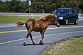
Humans and horses are often brought into proximity on the island.
-
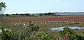
Egrets in Assateague's marshes
-
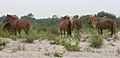
Feral horses on Assateague Island
-
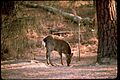
Deer on Assateague
-

Saltwater cowboys round up ponies on Assateague and herd them down the beach at sunrise.
-

Swimming from Assateague for Pony Penning Day on Chincoteague
-

Winter 2022 on Assateague Island
-

Snow blankets Assateague Island in January 2022
-

A winter scene on Assateague Island in January 2022


See also
 In Spanish: Isla Assateague para niños
